
Metagou
| Metagou | |||

|
|||

|
|||
| Data | |||
| surface | 7.69 km² | ||
| population | 1,677 (2015) | ||
| Chefe de Suco | Luís Freitas (election 2009) |
||
| Aldeias | Population (2015) | ||
| Assorlema | 674 | ||
| Caleulema | 471 | ||
| Metiluli | 532 | ||
|
|||

Metagou is an East Timorese suco in the administrative office of Bazartete ( municipality of Liquiçá ).
geography
| Metagou | ||
| places | position | height |
| Assorlema | 8 ° 38 ′ S , 125 ° 22 ′ E | 1159 m |
| Caileulema | 8 ° 38 ′ S , 125 ° 22 ′ E | 986 m |
| Kailelilema | 8 ° 37 ′ S , 125 ° 21 ′ E | 517 m |
| Metaluli (north) | 8 ° 37 ′ S , 125 ° 22 ′ E | 838 m |
| Metaluli (south) | 8 ° 38 ′ S , 125 ° 22 ′ E | 986 m |
Before the 2015 regional reform, Metagou had an area of 6.28 km². Now there are 7.69 km². The Suco is to the west of the administrative office. To the north lies the Suco Maumeta , east of the Suco Fatumasi and southeast of the Suco Leorema . In the east, Metagou borders on the administrative office of Liquiçá with its sucos Luculai and Dato . The rivers Nunupupolo and Hatunapa arise on the northeastern border , but leave Metagou immediately to the north, where they later unite to form the Carbutaeloa . The Eanaloa rises on the northwest border and unites at the extreme tip of Metagou with the Gaulara to form the Gularkoo .
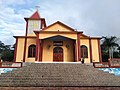
The village of Kailelilema lies between the Eanaloa and Nunupupolo rivers . In the northwest is the place Metaluli , which separates into two parts, in the center Caileulema ( Kaileulema ) and Lebuana and in the south Assorlema ( Asorlema ). The Escola Primaria Metagou primary school is located in Caileulema . Metagou Church was consecrated in 1994.
In the Suco are the three Aldeias Assorlema , Caleulema and Metiluli .
- Metagou Church


Residents
The Suco has 1677 inhabitants (2015), of which 829 are men and 848 women. The population density is 218.0 inhabitants / km². There are 280 households in the Suco. Over 95% of the population give Tokodede as their mother tongue. More than 2% speak Mambai , almost 2% Tetum Prasa and a minority Kemak .
politics
In the 2004/2005 elections , Salvador da Silva was elected Chefe de Suco. In the 2009 elections won Luís Freitas .
Web links
- Results of the 2010 census for the Suco Metagou ( tetum ; PDF; 8.2 MB)
- Results of the 2015 census for the Suco Metagou (tetum; PDF)
- Seeds of Life: Suco information sheets Bazartete (tetum)
Individual evidence
- ↑ a b c d Direcção-Geral de Estatística : Results of the 2015 census , accessed on November 23, 2016.
- ↑ Fallingrain.com: Directory of Cities, Towns, and Regions in East Timor
- ↑ Direcção Nacional de Estatística: Population Distribution by Administrative Areas Volume 2 English ( Memento from January 5, 2017 in the Internet Archive ) (Census 2010; PDF; 22.6 MB)
- ^ Timor-Leste GIS-Portal ( Memento from June 30, 2007 in the Internet Archive )
- ↑ List of polling stations for the parliamentary elections in East Timor 2007 (PDF file; 118 kB)
- ↑ UNMIT: Timor-Leste District Atlas version 02, August 2008 ( Memento of December 3, 2011 in the Internet Archive ) (PDF; 486 kB)
- ↑ Image of the memorial plaque for the inauguration
- ↑ Jornal da Républica with the Diploma Ministerial n. 199/09 ( Memento of February 3, 2010 in the Internet Archive ) (Portuguese; PDF; 323 kB)
- ↑ Results of the 2010 census for the Suco Metagou ( tetum ; PDF; 8.2 MB)
- ↑ Secretariado Técnico de Administração Eleitoral STAE: Eleições para Liderança Comunitária 2004/2005 - Resultados ( Memento of August 4, 2010 in the Internet Archive )
- ↑ Secretariado Técnico de Administração Eleitoral STAE: Eleições para Liderança Comunitária 2009 - Resultados ( Memento of August 4, 2010 in the Internet Archive )
![]() Map with all coordinates: OSM | WikiMap
Map with all coordinates: OSM | WikiMap
The administrative borders within East Timor changed in 2015. This article must therefore be checked and updated if necessary. See New Administrative Boundaries .