Ilat mood
| Ilat mood | ||

|
||

|
||
| Data | ||
| surface | 6.44 km² | |
| population | 1,634 (2015) | |
| Chefe de Suco | Juvinal Pires Amaral (election 2016) |
|
| Aldeias | Population (2015) | |
| Ilat mood | 635 | |
| Purugoa | 328 | |
| Tunero | 671 | |
|
|
||
Ilat-Laun ( Ilatalaun , Ilatlau , Hat-Laun ) is an East Timorese village and Suco Ilat-Laun in the administrative office of Bobonaro ( municipality of Bobonaro ). The Suco is part of the Marobo region .
The place
Ilat-Laun is located in the center of Sucos at an altitude of 609 m above sea level. There is a medical aid post and a primary school, the Escola Primaria Ilatlaun .
The Suco
| Ilat mood | ||
| places | position | height |
| Asubean | 8 ° 59 ′ S , 125 ° 20 ′ E | 606 m |
| Atuegas | 8 ° 59 ′ S , 125 ° 19 ′ E | 641 m |
| Borluli | 8 ° 58 ′ S , 125 ° 20 ′ E | 595 m |
| Ilat mood | 8 ° 59 ′ S , 125 ° 20 ′ E | 609 m |
| Tunero | 8 ° 59 ′ S , 125 ° 20 ′ E | 606 m |
The Suco has 1634 inhabitants (2015), 803 of whom are men and 831 women. The population density is 253.9 inhabitants / km². There are 274 households in the Suco. About 95% of the population name Kemak as their mother tongue. About 5% speak Tetum Prasa . In Marobo, the Kemak have mixed with the neighboring Bunak ethnic group for generations , which is why there are cultural differences between the Kemak of Atsabe and Marobo. The same goes for Obulo, with whom Marobo has close ties. The French anthropologist Brigitte Renard-Clamagirand studied the local culture between 1966 and 1970.
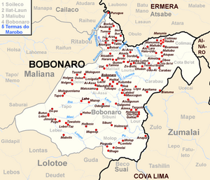
Before the 2015 regional reform, Ilat-Laun had an area of 5.34 km². Now there are 6.44 km². The Suco is to the north of the Bobonaro administrative office. In the south lies the Suco Atu-Aben and in the east and northeast Soileco . To the northwest lies the Cailaco administrative office with its Suco Raiheu across the Babonasolan River , which is part of the Lóis river system . It arises from the confluence of the Biabuil and Anasola rivers . The latter forms the western border between Ilat-Launs and Suco Ritabou ( Maliana administrative office ). In the south is the village of Atuegas , in the center the village of Ilat-Laun and in the northeast the towns of Tunero ( Tunu Ero , Tonero ), Asubean and Borluli .
In the Suco there are the three Aldeias Ilat-Laun , Purugoa and Tunero .
history

The Marobo-Kemak had a small empire, but it was under the dominance of the Kemak empire of Atsabe , on the periphery of which was Marobo. In March 1895, Governor José Celestino da Silva led an offensive against Marobo and the Obulo , which is closely related to him , in order to finally subdue them for Portugal .
politics
In the 2004/2005 elections , Adelino Afonso was elected Chefe de Suco. Lourenço Barreto Afonso won the elections in 2009 and Juvinal Pires Amaral in 2016 .
economy
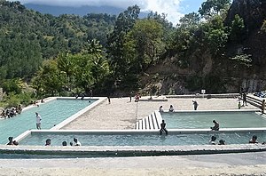
During the Portuguese colonial period, a bath with hot springs, the Termas do Marobo , was built in Ilat-Laun . The swimming pool, which is fed by the hot spring, still exists today and is now a tourist attraction.
literature
- Brigitte Renard-Clamagirand: Marobo, Une Sociiti Ema de Timor Central. Priface de G. Condominas Ase12 (Langues Et Civilizations de L'Asie Du Sud-Est Et Du Monde In) , 1982, ISBN 978-2-85297-123-3 (French)
Web links
- Results of the 2010 census for the Suco Ilat-Laun ( tetum ; PDF; 8.5 MB)
- Results of the 2015 census for the Suco Ilat-Laun (tetum; PDF)
- Seeds of Life: Suco information sheets Bobonaro (tetum)
Individual evidence
- ↑ a b c d Direcção-Geral de Estatística : Results of the 2015 census , accessed on November 23, 2016.
- ↑ UNMIT: Timor-Leste District Atlas version 02, August 2008 ( Memento of November 8, 2012 in the Internet Archive ) (PDF; 535 kB)
- ↑ List of polling stations for the parliamentary elections in East Timor 2007 (PDF file; 118 kB)
- ↑ Fallingrain.com: Directory of Cities, Towns, and Regions in East Timor
- ↑ Results of the 2010 census for the Suco Ilat-Laun ( tetum ; PDF; 8.5 MB)
- ^ A b Andrea K. Molnar: Died in the service of Portugal: Legitimacy of authority and dynamics of group identity among the Atsabe Kemak in East Timor , Journal of Southeast Asian Studies, Singapore 2005.
- ^ Center for Southeast Asian Studies, Northern Illinois University
- ↑ Direcção Nacional de Estatística: Population Distribution by Administrative Areas Volume 2 English ( Memento from January 5, 2017 in the Internet Archive ) (Census 2010; PDF; 22.6 MB)
- ^ Timor-Leste GIS-Portal ( Memento from June 30, 2007 in the Internet Archive )
- ↑ Jornal da Républica with the Diploma Ministerial n. 199/09 ( Memento of February 3, 2010 in the Internet Archive ) (Portuguese; PDF; 323 kB)
- ↑ History of Timor - Technical University of Lisbon ( Memento of the original from March 24, 2009 in the Internet Archive ) Info: The archive link was automatically inserted and has not yet been checked. Please check the original and archive link according to the instructions and then remove this notice. (PDF; 824 kB)
- ↑ Secretariado Técnico de Administração Eleitoral STAE: Eleições para Liderança Comunitária 2004/2005 - Resultados ( Memento of August 4, 2010 in the Internet Archive )
- ↑ Secretariado Técnico de Administração Eleitoral STAE: Eleições para Liderança Comunitária 2009 - Resultados ( Memento of August 4, 2010 in the Internet Archive )
- ↑ Jornal da República: Lista Naran Xefe Suku Eleito 2016 , December 2, 2016 , accessed on June 17, 2020.
- ↑ Jane's Oceania: Timor - Facts about Timor

