Tapo (Bobonaro)
| Tapo | ||

|
||

|
||
| Data | ||
| surface | 9.44 km² | |
| population | 624 (2015) | |
| Chefe de Suco | Xavier Cardoso Barreto (election 2016) |
|
| Aldeias | Population (2015) | |
| Oe-po | 469 | |
| Tapo Tas | 155 | |
|
|
||
Tapo ( Bunak for holy ax ) is an East Timorese place and Suco in the administrative office of Bobonaro ( municipality of Bobonaro ).
The place
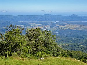
The place Tapo is located in the northwest of the Sucos at an altitude of 1258 m above sea level. There is a primary school in the village, the Escola Primaria Tapo .
The Suco
| Tapo | ||
| places | position | height |
| Oe-po | 9 ° 4 ′ S , 125 ° 16 ′ E | 1315 m |
| Tapo | 9 ° 3 ′ S , 125 ° 16 ′ E | 1258 m |
624 inhabitants live in the Suco (2015), 304 men and 320 women. The population density is 66.1 inhabitants / km². There are 150 households in the Suco. More than 95% of the residents state Bunak as their mother tongue. A small minority speaks Kemak .
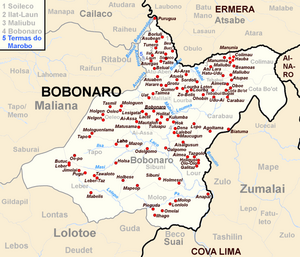
Before the 2015 regional reform, Tapo had an area of 13.09 km². Now it is 9.44 km². The Suco is located to the west of the Bobonaro administrative office. To the north is the Suco Oeleo , northeast Ai-Assa and south Leber . In the west lies the administrative office of Maliana with its sucos Saburai and Ritabou . The river Ilsa , which flows across the Suco to the east, forms part of the border with Ai-Assa and finally flows into the Masi , has its source in Tapo . The rivers are part of the Loumea system .
The only larger town besides Tapo is Oe-po ( Oepo ) in the southwest of Sucos.
The two Aldeias Oe-po and Tapo Tas are located in the Suco .
history
Former residents of Tapos only founded the lower-lying Suco Tapo / Memo a few generations ago . Ritual relationships still exist between the two sucos today.
The neighbors Tapo, Oeleo and Leber have had a long conflict behind them. For decades the men of the communities fought each other over land and borders. In the civil war in 1975 led to outbreaks of violence between them. Tapo and Oeleo were considered strongholds of the UDT and were loyal to the Portuguese colonial administration. Leber was considered the center of the pro- Indonesian APODETI . Tapo residents accuse FRETILIN supporters of driving hundreds of UDT supporters to Cova Lima and West Timor in 1975 . In August 1975 FRETILIN, supported by residents from Tapo and Oeleo, burned down hundreds of houses in Leber, too, and the residents had to flee into the mountains.
During the Indonesian occupation (1975-1999), the villages were initially divided into supporters and opponents of the Indonesians. A special unit of the Indonesian armed forces was stationed in Leber , while FRETILIN now found support in Tapo and Oeleo. In 1976/77 the Indonesian Army repeatedly intervened in the armed conflict. The Indonesians killed civilians in Tapo and Oeleo and destroyed hundreds of houses in Tapo. In May 1981, men from Tapo were forced to take part in the "Fence of Legs" campaign in which thousands of civilians roamed the island in search of FALINTIL guerrillas . In 1999 young people from the village were captured by the Indonesian occupiers and tortured at the military post in Maliana . She was then forced to serve in the Wanra Dadarus Merah Putih . Other recruits are said to have volunteered to join the pro-Indonesian militia. As a result of the Indonesian operation Donner after the independence referendum in 1999 , many residents fled to West Timor , where they stayed in camps until they could return.
In 2003 a meeting of representatives from the three sucos was organized. The gathering of events made it clear to them that the political alliances ran across the communities and that all three were suffering from the conflicts. This should make a peaceful future possible.
politics
In the 2004/2005 elections , Justino Viegas Amaral was elected Chefe de Suco. In the 2009 elections won Xavier Cardoso Barreto and was in 2016 re-elected.
Web links
- Results of the 2010 census for the Suco Tapo ( tetum ; PDF; 8.5 MB)
- Results of the 2015 census for the Suco Tapo (tetum; PDF)
- Seeds of Life: Suco information sheets Bobonaro (tetum)
Individual evidence
- ↑ a b c d Direcção-Geral de Estatística : Results of the 2015 census , accessed on November 23, 2016.
- ^ A b Antoinette Schapper: Finding Bunaq: The homeland and expansion of the Bunaq in central Timor ( Memento of October 24, 2013 in the Internet Archive ), p. 173, in: Andrew McWilliam, Elizabeth G. Traube: Land and Life in Timor -Leste: Ethnographic Essays , 2011
- ↑ UNMIT: Timor-Leste District Atlas version 02, August 2008 ( Memento of November 8, 2012 in the Internet Archive ) (PDF; 535 kB)
- ↑ Fallingrain.com: Directory of Cities, Towns, and Regions in East Timor
- ↑ Results of the 2010 census for the Suco Tapo ( tetum ; PDF; 8.5 MB)
- ↑ Direcção Nacional de Estatística: Population Distribution by Administrative Areas Volume 2 English ( Memento from January 5, 2017 in the Internet Archive ) (Census 2010; PDF; 22.6 MB)
- ^ Timor-Leste GIS-Portal ( Memento from June 30, 2007 in the Internet Archive )
- ↑ Jornal da Républica with the Diploma Ministerial n. 199/09 ( Memento of February 3, 2010 in the Internet Archive ) (Portuguese; PDF; 323 kB)
- ↑ "Part 10: Acolhimento and victim support" from the "Chega!" Report of the CAVR (English)
- ↑ Secretariado Técnico de Administração Eleitoral STAE: Eleições para Liderança Comunitária 2004/2005 - Resultados ( Memento of August 4, 2010 in the Internet Archive )
- ↑ Secretariado Técnico de Administração Eleitoral STAE: Eleições para Liderança Comunitária 2009 - Resultados ( Memento of August 4, 2010 in the Internet Archive )
- ↑ Jornal da República: Lista Naran Xefe Suku Eleito 2016 , December 2, 2016 , accessed on June 17, 2020.
