Colimau
| Colimau | ||

|
||

|
||
| Data | ||
| surface | 11.12 km² | |
| population | 1,364 (2015) | |
| Chefe de Suco | António de Jesus (election 2009) |
|
| Aldeias | Population (2015) | |
| Atub logo | 37 | |
| Beamoas | 476 | |
| Lo'o Dasi | 21st | |
| Manunia | 778 | |
| Tegoabe | 52 | |
|
|
||
Colimau ( Kolimau ) is a osttimoresisches village in Suco Colimau ( Office of Administration Bobonaro , community Bobonaro ).
The place
Colimau is located in the northwest of the Sucos at an altitude of 1778 m above sea level. There is a primary school in the village.
The Suco
| Colimau | ||
| places | position | height |
| Beamoas | 9 ° 0 ′ S , 125 ° 23 ′ E | 1778 m |
| Colimau | 8 ° 59 ′ S , 125 ° 23 ′ E | 1778 m |
| Hauba | 9 ° 0 ′ S , 125 ° 23 ′ E | 1778 m |
| Maliubu | 9 ° 0 ′ S , 125 ° 23 ′ E | 1462 m |
| Manunia | 8 ° 59 ′ S , 125 ° 23 ′ E | 1462 m |
| Manumea | 8 ° 59 ′ S , 125 ° 23 ′ E | ? |
1364 inhabitants live in Suco (2015), 681 of them are men and 683 women. The population density is 122.6 inhabitants / km². There are 232 households in the Suco. Over 95% of the population name Kemak as their mother tongue. Small minorities speak Bunak and Habun .
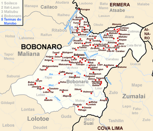
Before the 2015 regional reform, Colimau had an area of 12.18 km². Now there are 11.12 km². The Suco is located in the northeast of the Bobonaro administrative office. To the west of Colimau is the Suco Maliubu , southwest of Tebabui and south of the Suco Cota Bo'ot . In the east Colimau borders on the municipality of Ainaro with its Suco Mau-Ulo (administrative office Ainaro ), in the north on the municipality of Ermera with its Suco Atara (administrative office Atsabe ). The northern border is formed by the Marobo , a tributary of the Lóis .
The larger towns of the Sucos are all in the west of the Sucos and, with the exception of Manumea in the northwest , on the country road that leads from Maliana and Zumalai to Atsabe in the north, on to Gleno and finally Tibar on the north coast. The town of Colimau is closest to the border with Atara. It is followed southwards by the villages of Manunia ( Manonia ), Hauba , Maliubu and Beamoas ( Bea Moas , Biamoas ).
In the Suco there are the five Aldeias Atublogo , Beamoas , Lo'o Dasi , Manunia and Tegoabe ( Tego Abe ).
politics
From 1992 to 1999 Mateus de Jesus was elected Chefe de Suco of Colimau.
In the elections of 2004/2005 was António de Jesus elected Chefe de Suco and in 2009 re-elected.
Web links
- Results of the 2010 census for the Suco Colimau ( tetum ; PDF; 8.5 MB)
- Results of the 2015 census for the Suco Colimau (tetum; PDF)
- Seeds of Life: Suco information sheets Bobonaro (tetum)
Individual evidence
- ↑ a b c d Direcção-Geral de Estatística : Results of the 2015 census , accessed on November 23, 2016.
- ↑ UNMIT: Timor-Leste District Atlas version 02, August 2008 ( Memento of November 8, 2012 in the Internet Archive ) (PDF; 535 kB)
- ↑ Fallingrain.com: Directory of Cities, Towns, and Regions in East Timor
- ↑ Results of the 2010 census for the Suco Colimau ( tetum ; PDF; 8.5 MB)
- ↑ Direcção Nacional de Estatística: Population Distribution by Administrative Areas Volume 2 English ( Memento from January 5, 2017 in the Internet Archive ) (Census 2010; PDF; 22.6 MB)
- ^ Timor-Leste GIS-Portal ( Memento from June 30, 2007 in the Internet Archive )
- ↑ Jornal da Républica with the Diploma Ministerial n. 199/09 ( Memento of February 3, 2010 in the Internet Archive ) (Portuguese; PDF; 323 kB)
- ↑ SEAP: Biodata Moris Deputado Mateus de Jesus ( page no longer available , search in web archives ) Info: The link was automatically marked as defective. Please check the link according to the instructions and then remove this notice. , accessed on May 23, 2015.
- ↑ Secretariado Técnico de Administração Eleitoral STAE: Eleições para Liderança Comunitária 2004/2005 - Resultados ( Memento of August 4, 2010 in the Internet Archive )
- ↑ Secretariado Técnico de Administração Eleitoral STAE: Eleições para Liderança Comunitária 2009 - Resultados ( Memento of August 4, 2010 in the Internet Archive )
