Maluru
| Maluru | ||

|
||

|
||
| Data | ||
| surface | 33.95 km² | |
| population | 816 (2015) | |
| Chefe de Suco | Jeronimo Pinto (election 2009) |
|
| Aldeias | Population (2015) | |
| Loho Oan | 363 | |
| Macalosso | 272 | |
| Maluru | 181 | |
|
|
||
Maluru ( Maluro ) is an East Timorese Suco and Aldeia in the administrative office of Viqueque ( municipality of Viqueque ).
geography
| Maluru | ||
| places | position | height |
| Bibiluto | 8 ° 56 ' S , 126 ° 24' E | 35 m |
| Momoinento | 8 ° 56 ' S , 126 ° 24' E | 35 m |
| Rai Tahu | 8 ° 55 ' S , 126 ° 24' E | 35 m |
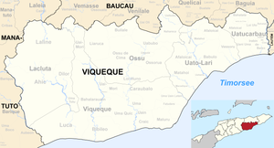
Before the 2015 territorial reform, Maluru had an area of 14.15 km². Now it is 33.95 km². The Suco is located in the southeast of the administrative office Viqueque on the banks of the Timor Sea . To the west, across the Cuha River is the Suco Uma Quic , to the east, across the Bularan River, the Suco Fatudere , to the northwest, across the Lee River (which flows into the Cuha), the Suco Uma Uain Craic and northeast of the Suco Caraubalo .
The southern coastal road, one of the most important traffic routes in East Timor, crosses the Suco. The place Bibiluto is located on it , south of it the village Momoinento ( Momomento ) and north the village Rai Tahu ( Raitahu ). There is a primary school in Bibiluto.
In the Suco there are the three Aldeias Loho Oan , Macalosso and Maluru .
Residents
816 inhabitants live in the Suco (2015), of which 388 are men and 428 women. The population density is 24.0 inhabitants / km². There are 181 households in the Suco. Over 92% of the population name Makasae as their mother tongue. 4% speak Tetum Terik and minorities Sa'ane or Idalaka .
history
Bibiluto was a traditional Timorese empire ruled by a Liurai . It appears on a list of Afonso de Castro , a former governor of Portuguese Timor , who listed 47 empires in 1868 , among others .
politics
In the elections of 2004/2005 was Jeronimo Pinto elected Chefe de Suco and in 2009 re-elected.
Web links
- Results of the 2010 census for the Suco Maluru ( tetum ; PDF)
- Results of the 2015 census for the Suco Maluru (tetum; PDF)
- Seeds of Life: Suco information sheets Viqueque (tetum)
Individual evidence
- ↑ a b c d Direcção-Geral de Estatística : Results of the 2015 census , accessed on November 23, 2016.
- ↑ Fallingrain.com: Directory of Cities, Towns, and Regions in East Timor
- ↑ Direcção Nacional de Estatística: Population Distribution by Administrative Areas Volume 2 English ( Memento from January 5, 2017 in the Internet Archive ) (Census 2010; PDF; 22.6 MB)
- ^ Timor-Leste GIS-Portal ( Memento from June 30, 2007 in the Internet Archive )
- ↑ UNMIT: Timor-Leste District Atlas version 02, August 2008 ( Memento from December 3, 2011 in the Internet Archive ) (PDF; 509 kB)
- ↑ Jornal da Républica with the Diploma Ministerial n. 199/09 ( Memento of February 3, 2010 in the Internet Archive ) (Portuguese; PDF; 323 kB)
- ↑ Results of the 2010 census for the Suco Maluru ( tetum ; PDF)
- ↑ TIMOR LORO SAE, Um pouco de história ( Memento of the original dated November 13, 2001 in the Internet Archive ) Info: The archive link was inserted automatically and has not yet been checked. Please check the original and archive link according to the instructions and then remove this notice.
- ↑ East Timor - PORTUGUESE DEPENDENCY OF EAST TIMOR ( Memento of February 21, 2004 in the Internet Archive )
- ↑ Secretariado Técnico de Administração Eleitoral STAE: Eleições para Liderança Comunitária 2004/2005 - Resultados ( Memento of August 4, 2010 in the Internet Archive )
- ↑ Secretariado Técnico de Administração Eleitoral STAE: Eleições para Liderança Comunitária 2009 - Resultados ( Memento of August 4, 2010 in the Internet Archive )

