Loidahar
| Loidahar | ||

|
||
| Data | ||
| surface | 10.05 km² | |
| population | 2,796 (2015) | |
| Chefe de Suco | Albino Soares (election 2009) |
|
| Aldeias | Population (2015) | |
| Cotalara | 1,053 | |
| Hatululi | 543 | |
| Manucol-Hata | 345 | |
| Soatala | 855 | |
|
|
||
Loidahar is an East Timorese suco in the Liquiçá administrative office ( Liquiçá municipality ).
geography
| Loidahar | ||
| places | position | height |
| Cotalara | 8 ° 36 ′ S , 125 ° 20 ′ E | 140 m |
| Hatululi | 8 ° 39 ′ S , 125 ° 20 ′ E | 921 m |
| Manucol-Hata | 8 ° 38 ′ S , 125 ° 20 ′ E | 756 m |
| Soatala | 8 ° 37 ′ S , 125 ° 19 ′ E | 547 m |
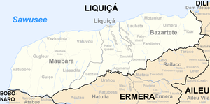
Before the 2015 regional reform, Loidahar had an area of 9.85 km². Now it is 10.05 km². The Suco is located in the north of the Liquiçá administrative office. The Suco Dato surrounds Loidahar on almost all sides , only in the southwest does it border the Suco Hatuquessi . The western border to Hatuquessi is initially formed by the Ricameta river , until it forms the Laklo with the Nomoro , which then follows the western border to Dato.
In the north, the municipality capital Vila de Liquiçá extends with the district of Cotalara ( Kotalara ) to Loidahar. Soatala is in the center and Manucol-Hata ( Manacolohata ) and Hatululi are in the south . There are three primary schools in Loidahar, including the Escola Primaria Loidahar . Loidahar is defined as "urban".
In the Suco there are the four Aldeias Cotalara , Hatululi , Manucol-Hata and Soatala .
Residents
The Suco has 2796 inhabitants (2015), of which 1368 are men and 1428 women. The population density is 278.3 inhabitants / km². There are 478 households in the Suco. Almost 86% of the population give Tokodede as their mother tongue. About 14% speak Tetum Prasa .
history
In April 1999, the residents of Loidahar and other sucos were forcibly deported to Vila de Liquiçá . Here they were forced to use intimidation and abuse to support the autonomy solution in the independence referendum , which provided for East Timor to remain with Indonesia . If they did not flee, men were forcibly recruited into the militia . In addition, people had to raise the flag of Indonesia and set up guard posts. Girls and young women had to dance at militia celebrations.
politics
In the 2004/2005 elections , Vicente de Jesus was elected Chefe de Suco. In the 2009 elections won Albino Soares .
Web links
- Results of the 2010 census for the Suco Loidahar ( tetum ; PDF; 8.2 MB)
- Results of the 2015 census for the Suco Loidahar (tetum; PDF)
- Seeds of Life: Suco information sheets Liquiçá (tetum)
Individual evidence
- ↑ a b c d Direcção-Geral de Estatística : Results of the 2015 census , accessed on November 23, 2016.
- ↑ Fallingrain.com: Directory of Cities, Towns, and Regions in East Timor
- ↑ Direcção Nacional de Estatística: Population Distribution by Administrative Areas Volume 2 English ( Memento from January 5, 2017 in the Internet Archive ) (Census 2010; PDF; 22.6 MB)
- ^ Timor-Leste GIS-Portal ( Memento from June 30, 2007 in the Internet Archive )
- ↑ List of polling stations for the parliamentary elections in East Timor 2007 (PDF file; 118 kB)
- ↑ UNMIT: Timor-Leste District Atlas version 02, August 2008 ( Memento of December 3, 2011 in the Internet Archive ) (PDF; 486 kB)
- ^ Ministry of Finance of East Timor: Liquiça Suco Reports
- ↑ Jornal da Républica with the Diploma Ministerial n. 199/09 ( Memento of February 3, 2010 in the Internet Archive ) (Portuguese; PDF; 323 kB)
- ↑ Results of the 2010 census for the Suco Loidahar ( tetum ; PDF; 8.2 MB)
- ↑ "Chapter 7.3 Forced Displacement and Famine" ( Memento of November 28, 2015 in the Internet Archive ) (PDF; 1.3 MB) from the "Chega!" Report of the CAVR (English)
- ↑ Secretariado Técnico de Administração Eleitoral STAE: Eleições para Liderança Comunitária 2004/2005 - Resultados ( Memento of August 4, 2010 in the Internet Archive )
- ↑ Secretariado Técnico de Administração Eleitoral STAE: Eleições para Liderança Comunitária 2009 - Resultados ( Memento of August 4, 2010 in the Internet Archive )
