Açumanu
| Açumanu | ||

|
||

|
||
| Data | ||
| surface | 10.88 km² | |
| population | 1,911 (2015) | |
| Chefe de Suco | Pascual da Silva (election 2009) |
|
| Aldeias | Population (2015) | |
| Caicasaico | 737 | |
| Hatumatilu | 567 | |
| Quirilelo | 270 | |
| Siscoelema | 337 | |
|
|
||
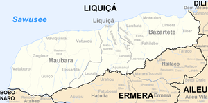
Açumanu ( Acumano , Asumano , Assumano , Acumanu ) is an East Timorese suco in the Liquiçá administrative office ( Liquiçá municipality ).
geography
| Açumanu | ||
| places | position | height |
| Boelema | 8 ° 40 ′ S , 125 ° 21 ′ E | 1037 m |
| Caicasaico | 8 ° 41 ′ S , 125 ° 21 ′ E | 978 m |
| Hatumatilu | 8 ° 41 ′ S , 125 ° 21 ′ E | ? |
| Mangkir | 8 ° 41 ′ S , 125 ° 21 ′ E | 978 m |
| Quirilelo | 8 ° 41 ′ S , 125 ° 20 ′ E | 784 m |
| Siscoelema | 8 ° 42 ′ S , 125 ° 21 ′ E | 723 m |
Before the 2015 territorial reform, Açumanu had an area of 10.95 km². Now it is 10.88 km². The Suco is located in the southeast of the Liquiçá administrative office. To the west is the Suoc Leotala and north of the Suco Darulete . In the east, Açumanu borders on the administrative office of Bazartete with its Suco Leorema and in the south on the administrative offices of Ermera with its Suco Ponilala and Hatulia with its sucos Lisapat , Mau-Ubo and Urahou, belonging to the municipality of Ermera . The Caicabaisala river initially follows the border with Darulete, separating the north of Açumanus from the rest of Suco and then follows the border with Leotala under the name Curiho until it flows into the Gleno , which in turn forms the southern border with Ermera. The rivers are part of the Lóis system .
North of the Caicabaisala is the village of Boelema . The villages of Mangkir , Caicasaico ( Caicassico ), Hatumatilu ( Hatu Matilo ) and Quirilelo ( Cirilelo ) are located near the south bank of Caicabaisala / Curiho . In the southeast is the place Siscoelema ( Sisicolema ). In Caicasaico there is a medical station and a primary school, the Escola Primaria Açumanu .
In the Suco are the four Aldeias Caicasaico , Hatumatilu , Quirilelo and Siscoelema .
Residents
1911 inhabitants (2015) live in the Suco, of which 978 are men and 933 women. The population density is 175.7 inhabitants / km². There are 328 households in the Suco. 60% of the population give Tokodede as their mother tongue. Almost 38% speak Tetum Prasa , minorities Mambai or Habun .
history
In Suco Açumanu, during the civil war against FRETILIN on August 13, 1975 , the UDT raised its flag in the Aldeia Caicasaico, burned houses and murdered six people in the Aldeia Siscoelema and Hatumatilu. Parts of the population fled to Leorema , Maubara or the nearby forest. At the end of 1979 there was a so-called transit camp in Caicasaico , in which the occupiers interned East Timorese civilians. On May 29, 1997, elections were held in which representatives of East Timor should be elected to the Indonesian parliament. Several attacks on the Indonesian occupying power and its supporters took place in the surrounding area. A hand grenade was thrown into the polling station in Açumanu. One soldier was wounded.
A forest fire on October 2nd and 3rd, 2019 caused great destruction in the Suco.
politics
In the 2004/2005 elections , Augusto dos Santos was elected Chefe de Suco. In the 2009 elections won Pascual da Silva .
Personalities
- Maria de Lourdes Martins Cruz (* 1962), nun and recipient of the Ramon Magsaysay Prize
Web links
- Results of the 2010 census for the Suco Açumanu ( tetum ; PDF; 8.2 MB)
- Results of the 2015 census for the Suco Açumanu (tetum; PDF)
- Seeds of Life: Suco information sheets Liquiçá (tetum)
Individual evidence
- ↑ a b c d Direcção-Geral de Estatística : Results of the 2015 census , accessed on November 23, 2016.
- ↑ Fallingrain.com: Directory of Cities, Towns, and Regions in East Timor
- ↑ Direcção Nacional de Estatística: Population Distribution by Administrative Areas Volume 2 English ( Memento from January 5, 2017 in the Internet Archive ) (Census 2010; PDF; 22.6 MB)
- ^ Timor-Leste GIS-Portal ( Memento from June 30, 2007 in the Internet Archive )
- ↑ List of polling stations for the parliamentary elections in East Timor 2007 (PDF file; 118 kB)
- ↑ UNMIT: Timor-Leste District Atlas version 02, August 2008 ( Memento of December 3, 2011 in the Internet Archive ) (PDF; 486 kB)
- ↑ Jornal da Républica with the Diploma Ministerial n. 199/09 ( Memento of February 3, 2010 in the Internet Archive ) (Portuguese; PDF; 323 kB)
- ↑ Results of the 2010 census for the Suco Açumanu ( tetum ; PDF; 8.2 MB)
- ↑ "Chapter 7.3 Forced Displacement and Famine" ( Memento of November 28, 2015 in the Internet Archive ) (PDF; 1.3 MB) from the "Chega!" Report of the CAVR (English)
- ↑ (INDONESIA-L) HRW / ASIA - East Timor Guerrilla Attacks: East Timor Guerrilla Attacks of June 4, 1997 ( Memento of September 19, 2006 in the Internet Archive )
- ↑ Secretariado Técnico de Administração Eleitoral STAE: Eleições para Liderança Comunitária 2004/2005 - Resultados ( Memento of August 4, 2010 in the Internet Archive )
- ↑ Secretariado Técnico de Administração Eleitoral STAE: Eleições para Liderança Comunitária 2009 - Resultados ( Memento of August 4, 2010 in the Internet Archive )
