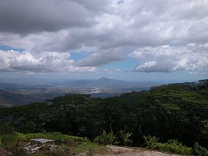
Leotala
| Leotala | ||

|
||

|
||
| Data | ||
| surface | 34.64 km² | |
| population | 2,543 (2015) | |
| Chefe de Suco | António dos Santos (election 2009) |
|
| Aldeias | Population (2015) | |
| Caimegoluli | 258 | |
| Hatumasi | 914 | |
| Lepa | 336 | |
| Manatee | 337 | |
| Tolema | 698 | |
|
|
||
Leotala ( Leoteala , Leotela ) is an East Timorese Suco in the administrative office of Liquiçá ( Liquiçá municipality ).
geography
| Leotala | ||
| places | position | height |
| Banitur | 8 ° 41 ′ S , 125 ° 18 ′ E | 429 m |
| Caimegoluli | 8 ° 40 ′ S , 125 ° 19 ′ E | 746 m |
| Cainego | 8 ° 43 ′ S , 125 ° 15 ′ E | ? |
| Hatumasi | 8 ° 40 ′ S , 125 ° 19 ′ E | 1011 m |
| Lepa | 8 ° 42 ′ S , 125 ° 17 ′ E | ? |
| Leva | 8 ° 41 ′ S , 125 ° 17 ′ E | 614 m |
| Manatee | 8 ° 41 ′ S , 125 ° 18 ′ E | 630 m |
| Tolema | 8 ° 40 ′ S , 125 ° 19 ′ E | 939 m |
| Vazetida Algar | 8 ° 40 ′ S , 125 ° 20 ′ E | 1070 m |
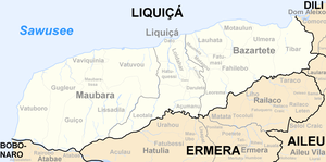
Before the 2015 regional reform, Leotala had an area of 39.29 km². Now there are 34.64 km². The Suco is located in the southwest of the administrative office Liquiçá. To the northeast are the sucos Hatuquessi , Dato , Darulete and Açumanu . In the north-west, Leotala borders on the administrative office of Maubara with its sucos Vatuvou and Lissadila , in the south on the administrative office of Hatulia, which belongs to the municipality of Ermera, with its sucos of Urahou and Aculau . The southern border forms the river Gleno , a tributary of the Lóis , in which all the rivers Leotalas flow. The center crosses the Manobira . The Curiho follows part of the border with Açumanu . The border with Lissadila initially shows the course of the Dirobatelau until it bends south and crosses Leotala. Shortly afterwards the Gumuloa meets the border between the two sucos and follows it to its confluence with the Gleno.
To the southwest is the village of Cainego . Between Dirobatelau and Rio Manobira are the places Banitur ( Bantur ) and Lepa , Leva is partly in the Suco Vatuvou. In the northeast are the localities of Manati , Caimegoluli ( Kaimegoluli ), Tolema , Hatumasi and Vazetida Algar . There are primary schools in Cainego, Lepa and Vazetida Algar.
The five Aldeias Caimegoluli , Hatumasi , Lepa , Manati and Tolema are located in the Suco .
In the mountains near Fazenda and Algarve , rainfall of 2143 to 2496 mm per year is reached. These are the rainiest areas in the municipality of Liquiçás.
Residents
The Suco has 2543 inhabitants (2015), of which 1244 are men and 1299 women. The population density is 73.4 inhabitants / km². There are 424 households in the Suco. 70% of the population give Tokodede as their mother tongue. Over 28% speak Tetum Prasa , minorities Mambai or Resuk .
history
In 1975 Indonesia began to occupy East Timor. The last parts of Liquiça, like Leotala, were conquered in early 1978.
As of January 1999, up to 5100 refugees seeking protection from the violence surrounding the independence referendum gathered in Faulara . Faulara was a resettlement camp that had existed since 1996 and originally had 1,600 residents. Some of the refugees were also housed in outposts, such as Banitur, eight kilometers away. On July 16, the pro-Indonesian militia Besi Merah Putih (BMP) attacked the camp.
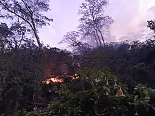
A forest fire on October 2nd and 3rd, 2019 caused great destruction in the Suco.
politics
In the 2004/2005 elections , Altino Campos dos Santos was elected Chefe de Suco. In the 2009 elections , António dos Santos won .
Personalities
- João Viegas Carrascalão (1945–2012), East Timorese politician
- Natália Carrascalão Antunes (* 1952), Portuguese politician and East Timorese diplomat
Web links
- Results of the 2010 census for the Suco Leotala ( tetum ; PDF; 8.2 MB)
- Results of the 2015 census for the Suco Leotala (tetum; PDF)
- Seeds of Life: Suco information sheets Liquiçá (tetum)
Individual evidence
- ↑ a b c d Direcção-Geral de Estatística : Results of the 2015 census , accessed on November 23, 2016.
- ↑ Fallingrain.com: Directory of Cities, Towns, and Regions in East Timor
- ↑ Direcção Nacional de Estatística: Population Distribution by Administrative Areas Volume 2 English ( Memento from January 5, 2017 in the Internet Archive ) (Census 2010; PDF; 22.6 MB)
- ^ Timor-Leste GIS-Portal ( Memento from June 30, 2007 in the Internet Archive )
- ↑ UNMIT: Timor-Leste District Atlas version 02, August 2008 ( Memento of December 3, 2011 in the Internet Archive ) (PDF; 486 kB)
- ↑ Jornal da Républica with the Diploma Ministerial n. 199/09 ( Memento of February 3, 2010 in the Internet Archive ) (Portuguese; PDF; 323 kB)
- ↑ Liquiçá District Development Plan 2002/2003 ( Memento of April 8, 2015 in the Internet Archive ) (English; PDF; 376 kB)
- ↑ Results of the 2010 census for the Suco Leotala ( tetum ; PDF; 8.2 MB)
- ↑ a b "Chapter 7.3 Forced Displacement and Famine" ( Memento of November 28, 2015 in the Internet Archive ) (PDF; 1.3 MB) from the "Chega!" Report of the CAVR (English)
- ↑ Secretariado Técnico de Administração Eleitoral STAE: Eleições para Liderança Comunitária 2004/2005 - Resultados ( Memento of August 4, 2010 in the Internet Archive )
- ↑ Secretariado Técnico de Administração Eleitoral STAE: Eleições para Liderança Comunitária 2009 - Resultados ( Memento of August 4, 2010 in the Internet Archive )


