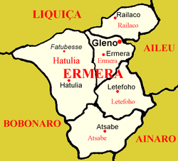
Ermera
| Ermera | ||
|---|---|---|
|
|
||
| Coordinates | 8 ° 45 ′ S , 125 ° 24 ′ E | |

|
||
| Basic data | ||
| Country | East Timor | |
| Ermera | ||
| Administrative office | Ermera | |
| ISO 3166-2 | TL-ER | |
| Suco | Poets | |
| height | 1195 m | |
| Residents | 8133 (2010) | |
| founding | 1979-1983 | |
|
Main street in Ermera with a view of the parish church
|
||
Ermera ( Vila Ermera , until 1936: Hermera ) is the former capital of the East Timorese municipality of Ermera . "Ermera" means "red water" in Mambai .
geography
The settlement Ermera, in the center of the Sucos Poetete ( administrative office Ermera ), is a loosely connected settlement from the places Poetete , Poepun ( Poepung ) and Loblala . Ermera is 1195 m above sea level. To the state capital Dili it is about 30 km to the northeast as the crow flies, on the road through the mountains past the municipal capital Gleno is 58 km. 13,142 inhabitants live in the village (2006).
climate
The average temperature over the year is 22.2 ° C, the highest monthly average temperature is 26.8 ° C and the lowest is 17.6 ° C. It can get uncomfortably cool, especially at night.
history
At the beginning of 1976, the Indonesian invasion forces reached Ermera. Part of the population fled to the mountains out of fear. After the capture of Samara (Hatulia administrative office) on April 24th, 500 of its inhabitants were interned in Ermera, where they suffered from starvation due to the lack of food. There were further internment camps for civilians, so-called transit camps , in what was then the Ermera sub- district at the end of 1979 in Borohei (Suco Humboe), Mangero (Suco Riheu), Hotklokat (Suco Lauala) and Falimanu .
At the beginning of 1979, around a hundred men from the previous district capital Ermera and Suco Ponilala were brought by the Indonesian occupying forces to the place where the city of Gleno is today. The Indonesian military forced the men to clear the previously uninhabited area and remove the vegetation so that the new city could be built here. If the forced laborers failed to complete their daily quota, they were tortured as a punishment. Three men too sick to work were killed by the soldiers. Since it was not possible to create gardens at that time, food was supplied by the military. When work on the new district capital, Gleno, was finished in 1983, the military stopped supplies. The families of the forced laborers have now also been forcibly relocated to Gleno. Because basic gardens had still not been laid out, deaths from starvation occurred. It was not until 1985 that the residents of Glenos were allowed to move freely.
On April 10, Indonesian soldiers and Darah Merah militiamen burned down dozens of houses in the town of Ermera.
Facilities
Ermera has a helipad, a primary school ( Escola Primaria Katolika Porahein ), a pre-secondary school, a secondary school ( Escola Secundaria Katolik No. 746 ) and a community health center. The East Timor Institute of Business (IOB) runs parallel classes in Ermera.
The parish church (Igreja Matriz) dates from the Portuguese colonial times. It was destroyed in World War II and then rebuilt. It forms one end of the main street of Ermera, at the other end is the villa of the former landowner. Steps lead from the street to the church. Below is a tile image ( azulejo ) of Mother Fatima typical of Portugal .
Personalities
- Eduardo de Jesus Barreto (* 1951), politician
- João Maia da Conceicão (* 1969), politician
- Maria da Costa Exposto (* 1960), politician
- Rui Manuel Hanjam (* 1969), politician
- Cláudio de Jesus Ximenes , President of the Tribunal de Recurso de Timor-Leste
- Gabriel Ximenes (1956–2009), politician
Web links
Individual evidence
- ↑ Ministry of State Administration and Territorial Management ( Memento of the original from September 5, 2014 in the Internet Archive ) Info: The archive link was automatically inserted and has not yet been checked. Please check the original and archive link according to the instructions and then remove this notice. (English)
- ↑ Geoffrey Hull : The placenames of East Timor , in: Placenames Australia (ANPS): Newsletter of the Australian National Placenames Survey, June 2006, pp. 6 & 7, ( Memento of the original from February 14, 2017 in the Internet Archive ) Info: The archive link was inserted automatically and has not yet been checked. Please check the original and archive link according to the instructions and then remove this notice. accessed on September 28, 2014.
- ^ Timor-Leste GIS-Portal ( Memento from June 30, 2007 in the Internet Archive )
- ↑ UNMIT: Timor-Leste District Atlas version 02, August 2008 ( Memento of the original from December 3, 2011 in the Internet Archive ) Info: The archive link has been inserted automatically and has not yet been checked. Please check the original and archive link according to the instructions and then remove this notice. (PDF; 584 kB)
- ^ Asian Development Bank: TIM: District Capitals Water Supply Project - Rehabilitation of Lake Lehumo , September 2011 , accessed February 23, 2014.
- ↑ a b c CAVR Chega Files: Part 7.3: Forced Displacement and Famine ( Memento of the original from November 28, 2015 in the Internet Archive ) Info: The archive link was inserted automatically and has not yet been checked. Please check the original and archive link according to the instructions and then remove this notice. (PDF; 1.3 MB)
- ↑ a b List of polling stations for the parliamentary elections in East Timor 2007 (PDF file; 118 kB)
- ↑ 2015 IOB General Information , accessed June 12, 2017.


