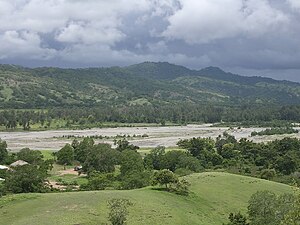
Haturalan
| Haturalan | ||

|
||

|
||
| Data | ||
| surface | 61.38 km² | |
| population | 995 (2015) | |
| Chefe de Suco | Gaspar José F. da Costa (election 2009) |
|
| Aldeias | Population (2015) | |
| Ralan | 235 | |
| Uma-Iuc | 344 | |
| Ueboro | 416 | |
|
|
||
Haturalan ( Hatularan ) is an East Timorese Suco in the administrative office of Laleia ( Manatuto municipality ).
geography
| Haturalan | ||
| places | position | height |
| Hatu Carau | ? | |
| Ralan | 8 ° 32 ' S , 126 ° 10' E | 121 m |
| Uma-Iuc | 8 ° 32 ' S , 126 ° 10' E | 80 m |
| Ueboro | 8 ° 32 ' S , 126 ° 10' E | 122 m |
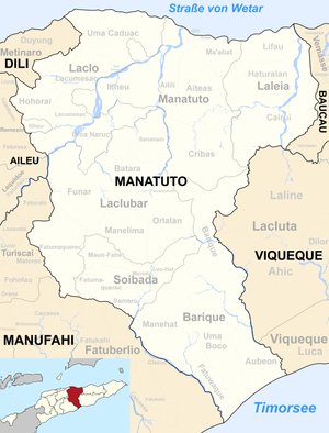
Before the 2015 regional reform, Haturalan had an area of 57.16 km². Now there are 61.38 km². The suco forms the middle part of the Laleia administrative office. To the north is the Suco Lifau , south of the Suco Cairui . In the west Haturalan borders on the administrative office of Manatuto with its Suco Aiteas , in the east on the administrative office of Vemasse, which belongs to the municipality of Baucau, with its sucos Uaigae and Vemasse . The river Laleia flows through the east of the Sucos , into which the Lago Haui flows in the south and the Lago Heuc in the north .
In the northeast, the administrative capital of Laleia with the districts Uma-Iuc ( Umaiuk ), Ralan ( Ranan ) and Ueboro ( Weboro , Beboro ) extends into the Suco Haturalan. In the southeast is the village of Hatu Carau .
The three Aldeias Ralan , Uma-Iuc and Ueboro are in the Suco .
Residents
995 inhabitants (2015) live in the Suco, of which 523 are men and 472 women. The population density is 16.2 inhabitants / km². There are 190 households in the Suco. Over 87% of the population name Galoli as their mother tongue. 7% speak Tetum Prasa , 3% Kairui , minorities Makasae , Midiki and Tetum Terik .
politics
In the 2004/2005 elections , Antão de Sousa was elected Chefe de Suco. In the 2009 elections won Gaspar José F. da Costa .
Web links
- Results of the 2010 census for the Suco Haturalan ( tetum ; PDF; 8.3 MB)
- Results of the 2015 census for the Suco Haturalan (tetum; PDF)
- Seeds of Life: Suco information sheets Laleia (tetum)
Individual evidence
- ↑ a b c d Direcção-Geral de Estatística : Results of the 2015 census , accessed on November 23, 2016.
- ↑ Fallingrain.com: Directory of Cities, Towns, and Regions in East Timor
- ↑ Direcção Nacional de Estatística: Population Distribution by Administrative Areas Volume 2 English ( Memento from January 5, 2017 in the Internet Archive ) (Census 2010; PDF; 22.6 MB)
- ↑ a b Timor-Leste GIS Portal ( Memento from June 30, 2007 in the Internet Archive )
- ↑ UNMIT: Timor-Leste District Atlas version 02, August 2008 ( Memento from December 3, 2011 in the Internet Archive ) (PDF; 581 kB)
- ↑ Jornal da República: Diploma Ministerial n ° 16/2017 , with corrections dated May 9, 2017 , accessed on March 12, 2019.
- ↑ Results of the 2010 census for the Suco Haturalan ( tetum ; PDF; 8.3 MB)
- ↑ Secretariado Técnico de Administração Eleitoral STAE: Eleições para Liderança Comunitária 2004/2005 - Resultados ( Memento of August 4, 2010 in the Internet Archive )
- ↑ Secretariado Técnico de Administração Eleitoral STAE: Eleições para Liderança Comunitária 2009 - Resultados ( Memento of August 4, 2010 in the Internet Archive )

