
Fuchsberg (Teunz)
|
Fuchsberg
community Teunz
Coordinates: 49 ° 29 ′ 37 ″ N , 12 ° 23 ′ 38 ″ E
|
||
|---|---|---|
| Height : | 518 m | |
| Incorporation : | 1978 | |
| Postal code : | 92552 | |
| Area code : | 09671 | |
Location of Fuchsberg in Bavaria |
||


Fuchsberg is a part of the municipality of Teunz and used to be an independent municipality. On May 1, 1978, it was incorporated into the municipality of Teunz in the eastern Bavarian district of Schwandorf . Since January 1, 1974, the municipalities of Teunz, Gleiritsch , Niedermurach and Winklarn have been amalgamated in the Oberviechtach administrative community .
geography
Fuchsberg is located in the Upper Palatinate North region in the northeastern part of the Schwandorf district, southwest of the Platte elevation. The place at 500 m height can be reached via the district road SAD 43 Teunz - Fuchsberg - Kühried - Wildstein .
history
Fuchsberg used to be a manor, but little is known about its origins. At today's Schlossbrauerei Fuchsberg there is a wall and a moat from the Middle Ages. The knight dynasty of the Zenger can be traced on Fuchsberg from 1321. The Muracher family followed in the 15th century, and the Satzenhofer family in the 16th to 18th centuries. The Ödmiesbach estate, to which Steinach bei Gleiritsch belonged, was part of the Hofmark Fuchsberg until 1604. A total of 63 properties belonged to Hofmark Fuchsberg in 1770.
Fuchsberg community
Church building
The Kingdom of Bavaria was divided into 15 districts in 1808, which were named after rivers based on the French model ( Naabkreis , Regenkreis , Unterdonaukreis , etc.). The districts were divided into district courts, which should be divided into individual municipal areas.
Fuchsberg becomes a community
The community of Fuchsberg had been part of the Neunburg vorm Wald regional court since 1820/21 , and from 1900 it belonged to the Oberviechtach district office . The villages of Haidhof with one family and Zieglhäuser with two families belonged to the political community of Fuchsberg with 49 families. In 1880 Haidhof came in exchange from the community of Fuchsberg to the community of Wildstein, while Hebermühle moved to the community of Fuchsberg.
Population development in the municipality of Fuchsberg
On the territory of the parish were
- 1840 361
- 1900 321
- 1919 315
- 1939 274 and
- 1970 counted 267 inhabitants.
Dissolution of the community of Fuchsberg
After the end of the Second World War, the municipality of Fuchsberg was assigned to the municipality of Teunz between 1946 and 1948, but then regained its independence. On May 1, 1978 the community Fuchsberg, to which the Hebermühle and the Tannenschleife belonged, was dissolved. The localities were incorporated into Teunz. The municipality of Teunz is part of the Oberviechtach administrative community .
education
Pre-school children are accommodated in the kindergarten in Teunz. The students from Fuchsberg attend the elementary school in Teunz and the Doktor-Eisenbarth-Mittelschule in Oberviechtach. There is a secondary school in Nabburg and a business school in Weiden; There are high schools in Oberviechtach, Nabburg and Weiden . The way to school can only be covered by buses.
Attractions
- St. Jakob , Church on the Way of St. James
- Fuchsberg Castle
- The Franconian Way of St. James , which is marked with a white shell on a light blue background, comes from the Jakobskirche , one kilometer away in a south-westerly direction . It leads south past the Fuchsberg bathing pond. The next stop is Teunz, three kilometers south of Fuchsberg .
societies
- Fuchsberg volunteer fire department
- Fruit and horticultural association Fuchsberg
- KLJB Fuchsberg
Picture gallery
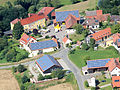
Fuchsberg Castle Brewery (2013)
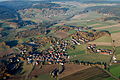
Fuchsberg, Kühried (2010)

Fuchsberg Castle (1796)
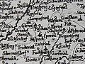
Map (1663)


literature
- Georg Hager: The art monuments of the Kingdom of Bavaria, Upper Palatinate and Regensburg . Volume II, individual volume 7: District Office Oberviechtach . Munich 1906, reprint ISBN 3-486-50437-1 .
- Emma Mages: Oberviechtach . In: Historical Atlas of Bavaria , part of Old Bavaria . Series I, issue 61. Komm. Für Bayerische Landesgeschichte, Munich 1996, ISBN 3-7696-9693-X ( digitized version ).
- Alois Köppl: Teunz, The community of Teunz from a bird's eye view , Gleiritsch 2013, ISBN 978-3-00-044012-0
- Joseph Heyberger, Chr. Schmitt, v. Wachter: Topographical-statistical manual of the Kingdom of Bavaria with an alphabetical local dictionary . In: K. Bayer. Statistical Bureau (Ed.): Bavaria. Regional and folklore of the Kingdom of Bavaria . tape 5 . Literary and artistic establishment of the JG Cotta'schen Buchhandlung, Munich 1867, urn : nbn: de: bvb: 12-bsb10374496-4 ( digitized version ).
- Kapellenbauverein Fuchsberg: Kapellenführer , 2000
- Fränkischer Albverein (Ed.): On the Jakobsweg from Tillyschanz via Schwandorf to Nuremberg. Verlag Seehars, 97215 Uffenheim 1997, ISBN 3-927598-22-4
Individual evidence
- ↑ Köppl, Alois, Teunz, 2013, p. 24
- ↑ State Archives Amberg, Standbuch 238, 78
- ^ Georg Hager: The art monuments of the Kingdom of Bavaria, Upper Palatinate and Regensburg . Volume II, individual volume 7: District Office Oberviechtach . Munich 1906, reprint ISBN 3-486-50437-1 , p. 16
- ↑ State Archives Amberg, Landsassen, number 3
- ↑ Emma Mages: Oberviechtach . In: Historical Atlas of Bavaria , part of Old Bavaria . Series I, issue 61. Komm. Für Bayerische Landesgeschichte, Munich 1996, ISBN 3-7696-9693-X , p. 110 ( digitized version ).
- ^ Emmering, Ernst, The Government of the Upper Palatinate, History of a Bavarian Central Authority, Contributions to the History and Regional Studies of the Upper Palatinate, Issue 20, Regensburg 1981, p. 12 ff.
- ↑ K. Bayer. Statistical Bureau (Ed.): Localities directory of the Kingdom of Bavaria. According to government districts, administrative districts, ... then with an alphabetical register of locations, including the property and the responsible administrative district for each location. LIV. Issue of the contributions to the statistics of the Kingdom of Bavaria. Munich 1888, Section III, Sp. 846 ( digitized version ).
- ↑ K. Bayer. Statistical Bureau (Ed.): Directory of localities of the Kingdom of Bavaria, with alphabetical register of places . LXV. Issue of the contributions to the statistics of the Kingdom of Bavaria. Munich 1904, Section II, Sp. 893 ( digitized version ).
- ↑ Emma Mages: Oberviechtach . In: Historical Atlas of Bavaria , part of Old Bavaria . Series I, issue 61. Komm. Für Bayerische Landesgeschichte, Munich 1996, ISBN 3-7696-9693-X , p. 207-208 ( digitized version ).
- ↑ Kapellenbauverein Fuchsberg, Kapellenführer, On the history of the castle and town of Fuchsberg, p. 9
- ↑ Bavarian State Statistical Office (Hrsg.): Historical municipality register: The population of the municipalities of Bavaria in the period from 1840 to 1952 (= contributions to Statistics Bavaria . Issue 192). Munich 1954, DNB 451478568 , p. 114 , urn : nbn: de: bvb: 12-bsb00066439-3 ( digitized version ).
- ↑ a b c Bavarian State Statistical Office (Hrsg.): Historical municipality register: The population of the municipalities of Bavaria in the period from 1840 to 1952 (= contributions to Statistics Bavaria . Issue 192). Munich 1954, DNB 451478568 , p. 117 , urn : nbn: de: bvb: 12-bsb00066439-3 ( digitized version ).
- ^ Bavarian State Statistical Office (ed.): Official place directory for Bavaria . Issue 335 of the articles on Bavaria's statistics. Munich 1973, DNB 740801384 , p. 138 ( digitized version ).
- ↑ Kapellenbauverein Fuchsberg, Kapellenführer, On the history of the castle and town of Fuchsberg, p. 9
- ^ Fränkischer Albverein (Ed.): On the Way of St. James from Tillyschanz via Schwandorf to Nuremberg. Verlag Seehars, 97215 Uffenheim 1997, ISBN 3-927598-22-4 , p. 22
Web links

Burkhardsberg | Fuchsberg | Good Prince | Haidhof | Hebermühle | Hermannsried | Höcherlmühle | Kühried | Kühriedermühle | Miesmühle | Ödmiesbach | Ödreichersried | Schömersdorf | Fir bow | Teunz | Weiherhäusl | Wildstein | Zeinried