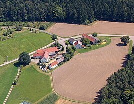
Zieglhäuser (Teunz)
|
Brick houses
community Teunz
Coordinates: 49 ° 30 ′ 10 ″ N , 12 ° 24 ′ 48 ″ E
|
|
|---|---|
| Height : | 580 m above sea level NHN |
| Residents : | 13 (May 27 1970) |
| Postal code : | 92552 |
| Area code : | 09677 |
|
Zieglhäuser in 2012
|
|
Zieglhäuser is a former part of the municipality of Teunz in the Schwandorf district .
The place is located 200 meters south of Haidhof in the Wildstein district and has two residential buildings (as of 2017). Today it is assigned to the Haidhof part of the municipality. At the 1970 census, the wasteland was still an officially named municipality of Teunz with thirteen residents.
history
The place is first mentioned in the "Matricula Dioceseos Ratisbonensis", the so called "Heckenstaller Matrikel" as "Zieghäusl". He always belonged to the Teunz parish and first to the Fuchsberg community in the Neunburg vorm Wald district office . Since 1885 at the latest, the place has belonged to the Wildstein community in the Neunburg vorm Wald district office, which in 1900 became part of the newly founded Oberviechtach district office . Zieglhäuser has only been part of the Teunz community since 1972, when the Wildstein community was incorporated into Teunz as part of the regional reform in Bavaria .
Population development
- 1838: 16 souls, 3 houses
- 1860: 10 souls, 2 houses
- 1871: 8 inhabitants, 9 buildings
- 1875: 8 inhabitants
- 1885: 10 residents, 2 residential buildings
- 1900: 13 inhabitants, 2 residential buildings
- 1913: 10 souls, 2 houses
- 1925: 12 residents, 2 residential buildings
- 1950: 16 residents, 2 residential buildings
- 1961: 12 residents, 2 residential buildings
- 1970: 13 residents, 2 residential buildings
Web links
- Emma Mages: Oberviechtach . Historical Atlas of Bavaria. Ed .: Commission for Bavarian State History at the Bavarian Academy of Sciences. Part Altbayern, issue 61. Munich 1996, ISBN 3-7696-9693-X ( digitized version ).
Individual evidence
- ↑ a b c Bavarian State Statistical Office (Hrsg.): Official local directory for Bavaria . Issue 335 of the articles on Bavaria's statistics. Munich 1973, DNB 740801384 , p. 141 ( digitized version ).
- ↑ Bavaria Atlas of the Bavarian State Government ( notes )
- ↑ Emma Mages: Oberviechtach . Historical Atlas of Bavaria. Ed .: Commission for Bavarian State History at the Bavarian Academy of Sciences. Part Altbayern, issue 61. Munich 1996, ISBN 3-7696-9693-X , p. 182 ( digitized version ).
- ↑ Bavarian State Office for Statistics and Data Processing (Hrsg.): The municipalities of Bavaria according to the territorial status May 25, 1987. The population of the municipalities of Bavaria and the changes in the acquisitions and territory from 1840 to 1987 (= contributions to Statistics Bavaria . Issue 451). Munich 1991, p. 84 , urn : nbn: de: bvb: 12-bsb00070717-7 ( digitized version - footnote 27).
- ↑ Josepf Lipf (Editor): matrikel bishopric of Regensburg . Ed .: Diocese of Regensburg. Pustet, Regensburg 1838, p. 189 ( digitized version ).
- ^ Diocese of Regensburg (ed.): Matriculation of the Diocese of Regensburg : according to the general parish and church description from 1860 ... Regensburg 1863, p. 257 ( digitized version ).
- ↑ Kgl. Statistical Bureau (ed.): Complete list of localities of the Kingdom of Bavaria. According to districts, administrative districts, court districts and municipalities, including parish, school and post office affiliation ... with an alphabetical general register containing the population according to the results of the census of December 1, 1875 . Adolf Ackermann, Munich 1877, 2nd section (population figures from 1871, cattle figures from 1873), Sp. 899 , urn : nbn: de: bvb: 12-bsb00052489-4 ( digitized - municipality of Fuchsberg).
- ↑ Kgl. Statistical Bureau (ed.): Complete list of localities of the Kingdom of Bavaria. According to districts, administrative districts, court districts and municipalities, including parish, school and post office affiliation ... with an alphabetical general register containing the population according to the results of the census of December 1, 1875 . Adolf Ackermann, Munich 1877, section 3, p. 180 , urn : nbn: de: bvb: 12-bsb00052489-4 ( digital copy ).
- ↑ K. Bayer. Statistical Bureau (Ed.): Localities directory of the Kingdom of Bavaria. According to government districts, administrative districts, ... then with an alphabetical register of locations, including the property and the responsible administrative district for each location. LIV. Issue of the contributions to the statistics of the Kingdom of Bavaria. Munich 1888, Section III, Sp. 852 ( digitized version ).
- ↑ K. Bayer. Statistical Bureau (Ed.): Directory of localities of the Kingdom of Bavaria, with alphabetical register of places . LXV. Issue of the contributions to the statistics of the Kingdom of Bavaria. Munich 1904, Section II, Sp. 898 ( digitized version ).
- ^ Diocese of Regensburg (ed.): Register of the Diocese of Regensburg . ed. i. A. Sr Excellency of the Most Revered Bishop Dr. Antonius von Henle from the Episcopal Ordinariate Regensburg. Regensburg 1916, p. 384 ( digitized version ).
- ↑ Bavarian State Statistical Office (ed.): Localities directory for the Free State of Bavaria according to the census of June 16, 1925 and the territorial status of January 1, 1928 . Issue 109 of the articles on Bavaria's statistics. Munich 1928, Section II, Sp. 906 ( digitized version ).
- ↑ Bavarian State Statistical Office (ed.): Official place directory for Bavaria - edited on the basis of the census of September 13, 1950 . Issue 169 of the articles on Bavaria's statistics. Munich 1952, DNB 453660975 , Section II, Sp. 775 ( digitized version ).
- ↑ Bavarian State Statistical Office (ed.): Official city directory for Bavaria, territorial status on October 1, 1964 with statistical information from the 1961 census . Issue 260 of the articles on Bavaria's statistics. Munich 1964, DNB 453660959 , Section II, Sp. 572 ( digitized version ).
