
Vemasse
| Vemasse | |||

|
|||

|
|||
| Data | |||
| surface | 148.57 km² | ||
| population | 4,542 (2015) | ||
| Chefe de Suco | Carlos Freitas ( Acau ) (election 2009) |
||
| Aldeias | Population (2015) | ||
| Betulals | 1,504 | ||
| Lor | 1.166 | ||
| Oralan | 1,025 | ||
| Raha | 847 | ||
|
|||

Vemasse ( Vemassi, Vemase, Vermasse, Vemassey, Vemace , formerly Ade , before 1936: Vemassin ) is an East Timorese place and Suco in the northwest of East Timorese in the administrative office of Vemasse ( municipality of Baucau ). They are named after the former kingdom of Vemasse . The name is derived from "Wemasi" , the Galoli word for "salty water".
The place
overview

The village of Vemasse is the main town of the administrative office and sucos Vemasse. Almost 3,000 people live here. The village is located 28 km west of the municipal capital Baucau (39 km by road) and 70 km east of the state capital Dili at an altitude of 138 m , on the north coast of Timor and the relatively well-developed coastal road that connects Dili with the east of the country . The districts of Raha , Oralan , Bahamori and Lor are lined up on the road as if on a string of pearls . A little to the south is the district of Caicua .
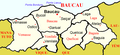
Location of the village of Vemasse in the municipality of Baucau
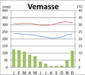
Climate diagram


Buildings

Vemasse is home to the Escola Presecundaria Vemasse pre-secondary school and a total of four primary schools. There is also a police station, a community health center and a helipad here.
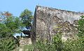
Vemasse is overlooked by the ruins of a Portuguese fortress, which can be seen from afar, from which the town and its surroundings - especially the valley of the river of the same name, which is spanned by a bridge built in 1992 - are clearly visible. The complex with its well-preserved enclosing walls has two gates. The fortress can be entered via the larger gate on the north side facing the sea with its 23-step outside staircase. Inside, the foundations of several buildings have been preserved, in some cases the remains of towers. During the Indonesian occupation, the local administration was based here.
In the main street of the village, a cannon was set up in front of the seat of the administrative office , which may have been in the fortress before. The Catholic parish church is nearby.

Fortress in Vemasse 2003

Fortress in Vemasse 2016
North gate of the fortress 2016
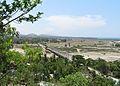
View from the fortress 2016


The Suco
| Vemasse | ||
| places | position | height |
| Bahamori | 8 ° 31 ' S , 126 ° 14' E | 84 m |
| Caicua | 8 ° 31 ' S , 126 ° 14' E | 174 m |
| Karabela | 8 ° 29 ′ S , 126 ° 17 ′ E | 17 m |
| Lor | 8 ° 30 ′ S , 126 ° 14 ′ E | 23 m |
| Oralan | 8 ° 30 ' S , 126 ° 13' E | 61 m |
| Raha | 8 ° 31 ' S , 126 ° 12' E | 52 m |
| Vemasse | 8 ° 31 ' S , 126 ° 13' E | 37 m |

Suco Vemasse has 4542 inhabitants (2015), 2240 of whom are men and 2302 women. The population density is 30.6 inhabitants / km². There are 795 households in the Suco. About 70% of the population name Waimaha as their mother tongue. A small minority speaks Midiki . Both are counted among the Kawaimina languages. About 15% speak Tetum Prasa , about 10% Galoli .
Before the 2015 regional reform, Vemasse had an area of 182.42 km². Now there are 148.57 km². The Suco occupies much of the west of the Vemasse Administrative Office and the entire coast to the north on the Strait of Wetar . To the east are the Sucos Ostico , Caicua and Ossouala and the Baucau administrative office with its Suco Bucoli . To the west of Vemasse are the Suco Uaigae and the administrative office of Laleia (municipality of Manatuto ) with its sucos Haturalan , Lifau and Cairui . To the south, Vemasse borders the municipality of Viqueque with the Sucos Laline ( Lacluta administrative office ) and Bibileo ( Viqueque administrative office ). The river Bina rises in the south . It flows south into the Mori , which forms the entire boundary of the Sucos in the south. The Mori is part of the Laleia river system , which flows into the Wetar Strait on the border between Vemasse and Lifau. The Bohodani also has its source in the south of Vemasse . It flows north and joins the Vemasse River . After the Bucaloli flows into the Vemasse , it leaves the Suco in the direction of Uaigae and returns to the Suco after the Robohicdi has flown . After crossing the town of Vemasse, the Vemasse River joins the Wetar Strait. The Manuleiden flows further east into the sea. The Vemasses rivers only carry water in the rainy season. Karabela ( Cairabela , Caravela ) is located on the coastal road east of the mouth of the Manuleiden .
The Suco Vemasse is divided into the four Aldeias Betulale , Lor , Oralan and Raha .
politics
In the elections of 2004/2005 was Carlos Freitas ( ACAU ) elected Chefe de Suco and in 2009 re-elected.
history


|

|
|
|
The church of Vemasse, during the post-WWII reconstruction in 1970 and in 2016.
|
||
According to legend, Vemasse received the name "salty water" from a prince of Luca , who fled here and drank thirstily from a spring that turned out to be salty.
Much of the municipality of Baucau was formerly part of the empire of Vemasse or was under its influence. The empire used to be called Ade . Traders from Makassar still had a great influence here until 1668/69 . In 1752 there was already a Catholic church in Vemasse.
Close relations existed with the island of Kisar, which is dominated by the Netherlands . They visited each other regularly, traded in gold and water buffalo and the Raja of Vonreli on Kisar paid a tribute to the Liurai of Vemasse. It was not until the end of the 19th century that the Portuguese governor of Timor, José Celestino da Silva (1894 to 1908) , stopped all contact, as the Raja refused to convert from Protestantism to Catholicism. But already 15 years later the contacts were renewed when the Raja von Kisar docked with a fleet of 20 small ships on the beach of Baucau.
After rumors arose that the Indonesian invaders had murdered ten civilians in Karabela on December 11, 1975, the population from Vemasse first fled to Mount Lame , on the southern edge of the town, where simple barracks were built. There they were joined by residents of Karabela and Bucoli. The population was able to return to their arable land for harvest as the Indonesians had not left any occupation troops in Vemasse. So the refugees could get enough food, but in the middle of March 1976 the Indonesians attacked the refugee camp with bazookas and mortars and destroyed both the huts and the food store. The residents fled along the Rio Vemasse eight kilometers further south, to Uaigae , where they again planted gardens for self-sufficiency. But as the fighting drew closer, they had to flee again until they finally found refuge again in Uai-Mori (today Suco Bibileo , 20 km south of Vemasse), under the protection of the FRETILIN . A base de apoio was created here, a base of resistance. Together with refugees from Dili, Viqueque and other parts of the country, they lived here for two years. Over time, food shortages grew as more and more people arrived. In 1978, Uai-Mori was also attacked by Indonesian forces. Most of the residents fled, some were captured by the Indonesians and taken to the Bucoli assembly camp.
The East Timorese freedom fighter Aquiles Freitas Soares and some of his followers were executed by FRETILIN in Lobito . Here was a resistance base ( bases de apoio ).
At the end of 1979 there was an Indonesian camp for East Timorese in the town of Vemasse, who were to be relocated by the occupiers for better control.
In November 2005, two East Timorese police were killed by a bomb dropped on their vehicle in Vemasse.
Sons and daughters
Carlos Filipe Ximenes Belo (* 1948), Nobel Peace Prize Laureate and former Bishop of Dili, was born in the village of Wailakama near Vemasse .
Web links
- Results of the 2010 census for the Suco Vemasse ( tetum ; PDF; 8.6 MB)
- Results of the 2015 census for the Suco Vemasse (tetum; PDF)
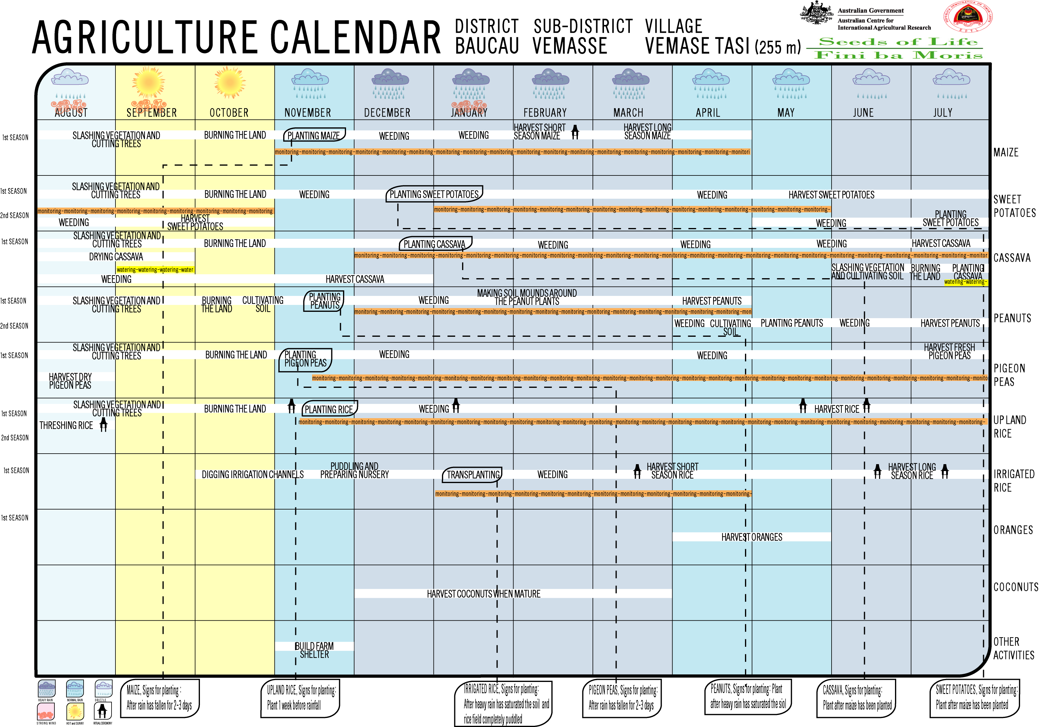
- Seeds of Life: Agriculture Calendar (English)
- Report by an Australian police officer who was stationed in Vemasse for UNTAET in 2001. (English)
- Seeds of Life: Suco information sheets Vemasse (tetum)
Individual evidence
- ↑ a b c d Direcção-Geral de Estatística : Results of the 2015 census , accessed on November 23, 2016.
- ↑ Boletim Oficial, XXXVII Ano - Numero 21, Govêrno Colonial, Diploma Legislativo N ° 85, May 27, 1936.
- ↑ a b Geoffrey Hull : The placenames of East Timor , in: Placenames Australia (ANPS): Newsletter of the Australian National Placenames Survey, June 2006, pp. 6 & 7, ( Memento of the original of February 14, 2017 in the Internet Archive ) Info: The archive link was inserted automatically and has not yet been checked. Please check the original and archive link according to the instructions and then remove this notice. accessed on September 28, 2014.
- ^ A b Friends of Vemasse
- ^ Seeds of Life
- ↑ List of polling stations for the parliamentary elections in East Timor 2007 (PDF file; 118 kB)
- ↑ UNMIT: Timor-Leste District Atlas version 02, August 2008 ( Memento of the original from December 3, 2011 in the Internet Archive ) Info: The archive link has been inserted automatically and has not yet been checked. Please check the original and archive link according to the instructions and then remove this notice. (PDF; 499 kB)
- ↑ Rodney Cocks: Timor Leste , p. 60.Singapore 2011
- ↑ Fallingrain.com: Directory of Cities, Towns, and Regions in East Timor
- ↑ Results of the 2010 census for the Suco Vemasse ( tetum ; PDF; 8.6 MB)
- ↑ Direcção Nacional de Estatística: Population Distribution by Administrative Areas Volume 2 English ( Memento of the original from January 5, 2017 in the Internet Archive ) Info: The archive link has been inserted automatically and has not yet been checked. Please check the original and archive link according to the instructions and then remove this notice. (2010 census; PDF; 22.6 MB)
- ^ Timor-Leste GIS-Portal ( Memento from June 30, 2007 in the Internet Archive )
- ↑ Jornal da Républica with the Diploma Ministerial n. 199/09 ( Memento of February 3, 2010 in the Internet Archive ) (Portuguese; PDF; 323 kB)
- ↑ Secretariado Técnico de Administração Eleitoral STAE: Eleições para Liderança Comunitária 2004/2005 - Resultados ( Memento of August 4, 2010 in the Internet Archive )
- ↑ Secretariado Técnico de Administração Eleitoral STAE: Eleições para Liderança Comunitária 2009 - Resultados ( Memento of August 4, 2010 in the Internet Archive )
- ↑ Susana Barnes, Hans Hägerdal, Lisa Palmer: An East Timorese Domain - Luca from Central and Peripheral Perspectives , p. 333, 2017, DOI: 10.1163 / 22134379-17302020 .
- ↑ Hans Hägerdal: Lords of the Land, Lords of the Sea; Conflict and Adaptation in Early Colonial Timor, 1600–1800 (2012).
- ↑ Hans Hägerdal: Rebellions or factionalism? Timorese forms of resistance in an early colonial context, 1650–1769 ( Memento of the original from December 8, 2015 in the Internet Archive ) Info: The archive link was inserted automatically and has not yet been checked. Please check the original and archive link according to the instructions and then remove this notice.
- ↑ History of Timor - Technical University of Lisbon ( Memento of the original from March 24, 2009 in the Internet Archive ) Info: The archive link was automatically inserted and has not yet been checked. Please check the original and archive link according to the instructions and then remove this notice. (PDF; 824 kB)
- ↑ a b c "Chapter 7.3 Forced Displacement and Famine" ( Memento of the original from November 28, 2015 in the Internet Archive ) Info: The archive link was inserted automatically and has not yet been checked. Please check the original and archive link according to the instructions and then remove this notice. (PDF; 1.3 MB) from the "Chega!" Report by CAVR (English)
- ↑ "Chapter 7.2 Unlawful Killings and Enforced Disappearances" ( Memento of the original from March 25, 2016 in the Internet Archive ) Info: The archive link was inserted automatically and has not yet been checked. Please check the original and archive link according to the instructions and then remove this notice. (PDF; 2.5 MB) from the "Chega!" Report by CAVR (English)
![]() Map with all coordinates: OSM | WikiMap
Map with all coordinates: OSM | WikiMap
The administrative borders within East Timor changed in 2015. This article must therefore be checked and updated if necessary. See New Administrative Boundaries .