Vemasse (river)
| Vemasse | ||
|
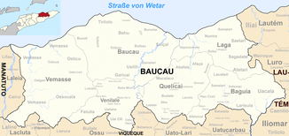
The Vemasse flows in the east of the municipality of Baucau. |
||
| Data | ||
| location | Baucau municipality , East Timor | |
| River system | Vemasse | |
| origin | Suco Baha Mori 8 ° 36 ′ 54 " S , 126 ° 22 ′ 5" E |
|
| muzzle | in the Strait of Wetar Coordinates: 8 ° 29 ′ 58 ″ S , 126 ° 13 ′ 32 ″ E 8 ° 29 ′ 58 ″ S , 126 ° 13 ′ 32 ″ E
|
|
| Left tributaries | Suni | |
| Right tributaries | Cuho, Dau, Bucaloli, Robohicdi, Naniale | |
| Small towns | Vemasse | |
| Communities | Uaigae , Raha , Oralan | |
|
The Vemasse, north of the town of the same name. |
||
The Vemasse is a river in the west of the East Timorese municipality of Baucau . It flows through most of the Vemasse administrative office .
course

The Vemasse rises in Suco Baha Mori , west of the place Lia-Oli ( Venilale administrative office ). It flows west into the Suco Loilubo (Vemasse administrative office). Located just outside the Suco Ossouala the ends of Fatulia coming Suni in Vemasse Subdistrict. Coming from Loilubo, the Cuho flows into the Vemasse. As it crosses Ossouala, the Dau , which rises in the Suco, flows into the Vemasse. Further west, the Vemasse forms the border between the Sucos Caicua and Ossouala, then between Osouala and the Suco Vemasse , before finally flowing to Vemasse. After the confluence of the Bohodani , which rises in the Suco, the Vemasse river swings north. From the east comes the Bucaloli , which also rises in Suco Vemasse. It soon follows the southern border between the Suco Vemasse and the Suco Uaigae and finally flows into the Vemasse River. The Vemasse now crosses Uaigae until the Robohicdi flows into it. The Robohicdi arises from the northern border between Uaigae and Vemasse Subdistrict, the Naniale and springing in Uaigae Metaannido . The Vemasse river now crosses the northern part of the Sucos Vemasse, past the towns of Raha , Vemasse and Oralan , until it finally flows into the Strait of Wetar . The northern coastal road, one of the country's most important traffic routes, crosses the river between Raha and the town of Vemasse.
Web links
Individual evidence
- ^ Timor-Leste GIS-Portal ( Memento from June 30, 2007 in the Internet Archive )

