
Soibada (Administrative Office)
| Soibada Administrative Office | |||

|
|||
|
|||
| Administrative headquarters | Soibada | ||
| surface | 130.02 km² | ||
| population | 3,294 (2015) | ||
| Sucos | Population (2015) | ||
| Fatumaquerec | 864 | ||
| Leo hat | 1,113 | ||
| Manlala | 451 | ||
| Maun-Fahe | 537 | ||
| Samoro | 329 | ||
| Overview map | |||

|
|||

Soibada is an East Timorese administrative office ( Portuguese Posto Administrativo ) in the municipality of Manatuto . The seat of the administration is in Suco Samoro in Soibada .
geography


Until 2014, the administrative offices were still referred to as sub-districts . Before the 2015 territorial reform, Soibada had an area of 130.34 km². Now it is 130.02 km².
The Soibada Administrative Office is located in the southwest of the municipality of Manatuto. To the north and west is the Laclubar administrative office, and the Barique administrative office to the east . In the south Soibada borders on the municipality of Manufahi with its administrative offices Fatuberlio . The administrative office is divided into five sucos : Fatumaquerec ( Fatumakerek ), Leo-Hat ( Leo Hat , Leohat ), Manlala , Maun-Fahe ( Maunfahe , Maunfahi ) and Samoro . The Sáhen crosses Soibada on its way south. The Quic , which rises in Samoro, and the Motana , the border river to Barique, come from the east and flow into it in the south of Soibada . The Quiclezen , a tributary of the Clerec, flows on the eastern border .
The main town of Soibada extends over the sucos Fatumaquerec, Leo-Hat and Manlala. One of the oldest schools in the country is located here, the Colégio Soibada. About a mile north of Soibada, in Suco Manlala, is the Aitara hill ( 608 m ), on the top of which there is a large banyan tree . This place has always been considered sacred. Next to the tree is a shrine of Mary dedicated to the mother of Aitara ( Nossa Senhora de Aitara ). She is said to have appeared here on October 16 to several women, which is why the mission was established in Soibada around 1900. The modern chapel surrounding the shrine was built on the foundations of the colonial chapel. Today it is a national pilgrimage site, where the apparition is commemorated every year with a big celebration.
- Climate data

Annual rainfall (2000)

Average annual temperature (2000)
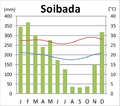
Climate diagram of Soibada


Residents

3294 people (2015) live in the Soibada administrative office, of which 1665 are men and 1629 women. The population density is 25.3 inhabitants / km². The largest language group is made up of the speakers of Tetum Terik (also called Soibada Tetun here ), a dialect of the official Tetum language . The average age is 16.6 years (2010, 2004: 16.5 years).
history


At the beginning of the 18th century, the Dominican Manuel de Santo António proselytized in Samoro and converted the local Liurai to Christianity. The area around Soibada belonged to the kingdom of Samoro. In 1756 Samoro, like many other empires in the east, refused to follow Wehale into an alliance with the Dutch. They stayed on the side of the Portuguese.
In 1899, Jesuits and sisters of the Canossians founded the mission in Soibada , which at that time consisted of simple huts. The vicar general , who was responsible for the south of the colony, took his seat here in 1900. In the same year construction began on the home of the missionaries, the Church of the Sacred Heart of Jesus and two Colégios . The Colégio Nuno Álvares Pereira for the boys opened in 1904. The Colégio da Imaculada Conceição for girls started operating around 1910. Soibada was the religious and educational center in Timor at that time. On December 23, 1910, however, the Jesuits were expelled from Soibada by order of the new, republican administration. Only with the new Portuguese constitution of 1933 and the laws of 1935 was the decree of 1910 repealed. On October 13, 1936, the Nossa Senhora da Fatima seminary was founded in Soibada . There was also a school for the formation of catechists, the Escola São Francisco Xavier . The Mission's buildings escaped destruction by the Japanese in World War II as the local ruler Raimundo Doutel Sarmento stood up for them. But after the war, Soibada began to decline. In 1951 the seminary and catechist school were moved to Dare and a diocese was established in Barique .
Soibada became the headquarters of FRETILIN immediately after the Indonesian invasion in 1975 . At their congress here in May 1976, the former Prime Minister of East Timor, Nicolau dos Reis Lobato, was officially elevated to the position of military commander. In 1977 the Indonesians captured Soibada. The residents of Manlala fled to the nearby forests of Lehutala , where they built huts near their plantings. Shortly afterwards they had to flee to Fatuberlio, where huts, gardens and even a small school were built. Here some residents died from hunger and disease. Two months later the Indonesians attacked again, which is why the people from Manlala had to flee again within Fatuberlio. The harvest was lost as a result. After further attacks by the Indonesian army, the residents of Soibada fled again in August 1978. They surrendered to the troops only three months later.
At the end of 1979 there were Indonesian camps for East Timorese in Soibada and near Maun-Fahe / Teras , who were to be relocated by the occupiers for better control.
politics
The administrator of the administrative office is appointed by the central government in Dili. In 2010 it was Francisco da Costa , in 2015 Agripino da Silva Sarmento .
economy

59% of households in Soibada grow cassava, 58% corn, 57% vegetables, 54% coffee, 48% coconuts and 35% rice. There is a small gold deposit near Fatumaquerec.
Web links
Individual evidence
- ↑ a b c d e Direcção-Geral de Estatística : Results of the 2015 census , accessed on November 23, 2016.
- ↑ Geoffrey Hull : The placenames of East Timor , in: Placenames Australia (ANPS): Newsletter of the Australian National Placenames Survey, June 2006, pp. 6 & 7, ( Memento of the original from February 14, 2017 in the Internet Archive ) Info: The archive link was inserted automatically and has not yet been checked. Please check the original and archive link according to the instructions and then remove this notice. accessed on September 28, 2014.
- ↑ a b Direcção Nacional de Estatística: 2010 Census Wall Chart (English) ( Memento of the original from August 12, 2011 in the Internet Archive ) Info: The archive link was automatically inserted and not yet checked. Please check the original and archive link according to the instructions and then remove this notice. (PDF; 2.5 MB)
- ^ Timor-Leste GIS-Portal ( Memento from June 30, 2007 in the Internet Archive )
- ^ Soibada Update - Our Lady of Aitara, The Marian Shrine of the Timorese people, October 31, 2010
- ↑ a b c Seeds of Life
- ↑ Direcção Nacional de Estatística: Census of Population and Housing Atlas 2004 ( Memento of November 13, 2012 in the Internet Archive ) (PDF; 14 MB)
- ^ Artur Teodoro de Matos: D. Frei Manuel de Santo António: missionário e primeiro bispo residente em Timor. Elementos para a sua biografia (1660–1733) ( Memento of the original from May 25, 2013 in the Internet Archive ) Info: The archive link was inserted automatically and has not yet been checked. Please check the original and archive link according to the instructions and then remove this notice. (Portuguese)
- ^ A b c Geoffrey C. Gunn: History of Timor. ( Memento of the original from March 24, 2009 in the Internet Archive ) Info: The archive link was inserted automatically and has not yet been checked. Please check the original and archive link according to the instructions and then remove this notice. Technical University of Lisbon (PDF file; 805 kB)
- ↑ a b c Património de Influência Portuguesa: Mission of the Sacred Heart of Jesus , accessed on November 15, 2016.
- ↑ a b "Chapter 7.3 Forced Displacement and Famine" ( Memento of the original from November 28, 2015 in the Internet Archive ) Info: The archive link was inserted automatically and has not yet been checked. Please check the original and archive link according to the instructions and then remove this notice. (PDF; 1.3 MB) from the "Chega!" Report by CAVR (English)
- ^ Government of Timor-Leste, June 8, 2010, Our Lady of Aitara, a possible destination for international pilgrimage
- ↑ Ministério da Administração Estatal: Administração Municipal ( Memento of the original from June 1, 2016 in the Internet Archive ) Info: The archive link has been inserted automatically and has not yet been checked. Please check the original and archive link according to the instructions and then remove this notice.
- ↑ Direcção Nacional de Estatística: Suco Report Volume 4 (English) ( Memento of the original from October 10, 2011 in the Internet Archive ) Info: The archive link was inserted automatically and has not yet been checked. Please check the original and archive link according to the instructions and then remove this notice. (PDF; 9.8 MB)
Coordinates: 8 ° 52 ′ S , 125 ° 56 ′ E
The administrative borders within East Timor changed in 2015. This article must therefore be checked and updated if necessary. See New Administrative Boundaries .