
Aitara
| Aitara | ||
|---|---|---|
 The banyan tree |
||
| height | 755 m | |
| location | Suco Manlala , Soibada Administrative Office , Manatuto Municipality , East Timor | |
| Coordinates | 8 ° 51 '24 " S , 125 ° 56' 49" O | |
|
||
| particularities | Place of pilgrimage with shrine and chapel | |

The Aitara (also Foho Aitara , Indonesian Gunung Aitara ) is a hill in East Timor with a height of 755 m . It is located in Suco Manlala ( Soibada Administrative Office , Manatuto Municipality ), about a mile north of Soibada .
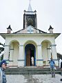
There is a large banyan tree on its top . This place has always been considered sacred. ( lulik ) Next to the tree is a shrine to Mary dedicated to the Holy Mother of Aitara ( Nossa Senhora de Aitara ). She is said to have appeared here on October 16 to several women, which is why the mission was established in Soibada around 1900. The modern chapel surrounding the shrine was built on the foundations of the colonial chapel. Today it is a national pilgrimage site, where the apparition is commemorated every year with a large celebration.

Altar with the Holy Mother of Aitara
Chapel before renovation
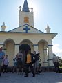
Chapel after the renovation


