Moa (Indonesia)
| Moa | ||
|---|---|---|
| The Leti Islands | ||
| Waters | Banda Sea , Timor Sea | |
| Archipelago | Moluccas | |
| Geographical location | 8 ° 13 ' S , 128 ° 11' E | |
|
|
||
| Residents | 7077 (2010) | |
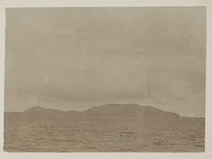
| Moa around 1900 | ||
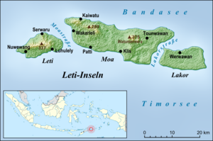
The Indonesian island of Moa ( indon. Pulau Moa ) belongs to the Leti Islands ( southern Moluccas ).
geography
Moa is the largest of the Leti Islands. It lies between Leti in the west and Lakor in the east. Moa has been forming the Kecamatan (sub-district) Pulau Moa ( Kabupaten southwestern Moluccas , Maluku province ) with the main town Weet on the north coast of Moa since March 20, 2013 . Before that, Moa and Lakor formed the Kecamatan Moa Lakor with Weet as the main town.
The Kecamatan Pulau Moa is divided into the seven Desa Wakarleli (531 inhabitants 2010), Kaiwatu (758), Pati ( Patti , 608), Werwaru (639), Klis (2,109), Tounwawan (2,191) and Moain (241).
Other places on Moa are Pati in the southwest and Tiakur on the west coast. The recently founded place Tiakur is the capital of the Kabupaten of the Southwest Moluccas.
Individual evidence
- ↑ a b Map of the Southwest Moluccas ( Memento of the original from November 22, 2011 in the Internet Archive ) Info: The archive link has been inserted automatically and has not yet been checked. Please check the original and archive link according to the instructions and then remove this notice.
- ↑ Penduduk Indonesia menurut desa 2010 ( Memento from March 27, 2014 in the Internet Archive ) (Indonesian; PDF; 6.0 MB), accessed on January 26, 2013
- ^ Kümmerly + Frey Rand Mc Nally: Internationaler Atlas , Westermann, 1986, ISBN 3-14-106025-8


