North Central Timor
| Kabupaten Timor Tengah Utara North Central Timor Governorate
|
||
|---|---|---|
 |
||
| Symbols | ||
|
||
| Basic data | ||
| Country | Indonesia | |
| province | East Nusa Tenggara | |
| Seat | Kefamenanu | |
| surface | 2,669.7 km² | |
| Residents | 229,603 (2010) | |
| density | 86 inhabitants per km² | |
| ISO 3166-2 | ID-NT | |
| Tautpah, South Biboki | ||
Coordinates: 9 ° 27 ' S , 124 ° 29' E
North Central Timor ( Timor Tengah Utara ) is a government district ( Kabupaten ) in the Indonesian part of West Timor . It is part of the East Nusa Tenggara Province . 229,603 inhabitants live here (2010).
geography
North Central Timor has an area of 2,669.66 km². The capital is Kefamenanu . The boundary line for the East Timorese enclave of Oe-Cusse Ambeno is the village Manusasi (District Westmiomaffo not fully understood).
Districts
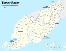
North Central Timor is divided into 24 districts ( Kecamatan ):
- Westmiomaffo (Miomaffo Barat)
- Central Miomaffo (Miomaffo Tengah)
- Musi
- Mutis
- East Miomaffo (Miomaffo Timur, Meomafó Leste)
- Noimuti (Noemuti)
- South Bikomi (Bikomi Selatan)
- Central Bikomi (Bikomi Tengah)
- Bikomi nilulate
- North Bikomi (Bikomi Utara)
- Naibenu
- Eastern Noimuti (Noemuti Timur)
- Kefamenanu (Kota Kefamenanu)
- Insana
- North Insana (Insana Utara)
- Westinsana (Insana Barat)
- Central Insana (Insana Tengah)
- Insana Fafinesu
- South Biboki (Biboki Selatan)
- Biboki Tanpah
- Biboki Moenleu
- North Biboki (Biboki Utara)
- Biboki Anleu
- Biboki Feotleu
Web links
Commons : North Central Timor - collection of images, videos and audio files
Individual evidence
- ^ The Jakarta Globe, March 22, 2011, East Timor, Indonesia Agree to Solve Border Problems
- ↑ List of the administrative units of Indonesia down to the Desas 2010 ( Memento from April 6, 2013 in the Internet Archive ) (English; PDF; 5.9 MB)


