Molo (West Timor)

The Raja of Molo visiting the Dutch representative. The Dutch flag is hanging upside down.
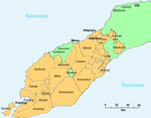
Molo ( Mollo , Molloh ) was a traditional empire in western Timor that was ruled by a Raja.
History and geography
In 1959, Molo, Amanatun and Amanuban were merged by the Indonesian government in the administrative district (Kabupaten) of South Central Timor (Timor Tengah Selatan) and in 1962/63 the last remnants of traditional rulers were finally eliminated.
Today Molo is divided into the districts ( Kecamatan ) of North Molo (Mollo Utara), South Molo (Mollo Sealtan), West Molo (Mollo Barat) and Central Molo (Molloh Tengah). In 1990 Molo had 63,188 inhabitants.
Web links
Commons : Molo - collection of images, videos and audio files
- The Raja of Molo ( Memento of November 20, 2008 in the Internet Archive )
Individual evidence
- ↑ Jacob Wadu include: Sejarah Pemerintahan Kabupaten Timor Tengah Selatan. Lembaga Penelitian Universitas Nusa Cendan, Penfui 2003, pp. 103-106.
- ↑ Penduduk Indonesia menurut desa 2010 ( Memento from March 27, 2014 in the Internet Archive ) (Indonesian; PDF; 6.0 MB), accessed on January 26, 2013.
Coordinates: 9 ° 43 ' S , 124 ° 14' E
