
Weldergoven
|
Weldergoven
City of Hennef (Sieg)
Coordinates: 50 ° 46 ′ 41 ″ N , 7 ° 18 ′ 48 ″ E
|
||
|---|---|---|
| Height : | 74 m above sea level NHN | |
| Residents : | 1009 (Jan 2020) | |
| Postal code : | 53773 | |
| Area code : | 02242 | |
Location of Weldergoven in North Rhine-Westphalia |
||
 Weldergoven at the victory
|
||

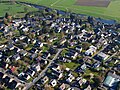
Weldergoven is a district of the city of Hennef (Sieg) , directly east of the city center and south of the Sieg . In addition, Weldergoven is located in the triangle between the Sieg line and the federal road 478 .

The first documentary mention of Weldergoven from 1143 by the Archbishop of Cologne , Arnold von Wied, confirms a foundation for the Rolandswerth nunnery : Otto and his son Heinrich von Bonn donated 20 yokes of arable land and three branches of fellable wood, two in Geisbach, to save their souls , one in Weldergoven; 12 Malter rye are paid for this own property .
The place Weldergoven was called Wendelinchhoven in 1143, then Welderinchoven (1247), Welderkoyven (1436) and 1487 Welderkoeven.
The small town, originally a collection of farms with farmers and fishermen, has grown significantly in the course of Hennef's urban development and is now a residential area .
Until 1934, Weldergoven belonged to the Geistingen community .
The Allner Hof is located near Weldergoven .
Every year in Weldergoven the "Scheunenfest" takes place, which takes place in an old barn, formerly from Attenberg near Blankenberg . The organizer of many other activities of the village community is the interest group Weldergoven e. V., which was founded in 1971.
Weldergoven from the west

The "Allner Hof" near Weldergoven


literature
- Helge Göhring: Weldergoven, city of Hennef (Sieg), historical - folkloric. ISBN 3-930246-03-1 .
Web links
Individual evidence
- ^ Hennef: Housing directory , residents ' registration office of the city of Hennef

Adscheid | Ahrenbach | Allner | Altenbödingen | Old luck | Auel | Beiert | Mountain | Blankenbach | Bödingen | Bröl | Bülgenauel | Büllesbach | Büllesfeld | Dahlhausen | Dambroich | Darscheid | Depensiefen | Derenbach | Dondorf | Dürresbach | Eichholz | Eulenberg | Fernegierscheid | Atrocities | Hahnenhardt | Halberg | Halmshanf | Hemp | Happerschoß | House Oelgarten | Heckelsberg | Womb | Hennef Center | Hermesmühle | Hofen | Hommerich | Hossenberg | Hove | Hüchel | Hülscheid | Issertshof | Käsberg | Kningelthal | Knippgierscheid | Köschbusch | Kraheck | Kümpel | Kurenbach | Kurscheid | Lanzenbach | Lauthausen | Lescheid | Lichtenberg | Liesberg | Löbach | Lückert | Meisenbach | Michelshohn | Mittelscheid | Niederhalberg | Oberauel | Oberhalberg | Petershohn | Raveneck | Ravenstein | Rott | Röttgen | Rütsch | Thief | Scheuren | Scheurenmühle | Söven | Sommershof | City of Blankenberg | Stone | Shock village | Striefen | Addiction divorce | Theishohn | Uckerath | Water heat | Weingartsgasse | Weldergoven | Wellesberg | Westerhausen | Reverberation | Wiersberg | Rock-nonsense | To the Farm