Meisenbach (Hennef)
|
Meisenbach
City of Hennef (Sieg)
Coordinates: 50 ° 42 ′ 56 ″ N , 7 ° 25 ′ 30 ″ E
|
||
|---|---|---|
| Height : | 230–240 m above sea level NN | |
| Residents : | 74 (Jan 2020) | |
| Postal code : | 53773 | |
| Area code : | 02248 | |
|
Location of Meisenbach in North Rhine-Westphalia |
||
Meisenbach is a district of the city of Hennef (Sieg) in the Rhein-Sieg district in North Rhine-Westphalia .
location
The place is lonely at an altitude of 230 to 240 meters above sea level on the slopes of the Westerwald , but still belongs to the Bergisches Land nature park . Distant neighboring towns are Obereip and Kircheib in the east, Griesenbach and Irmeroth in the south, Eichholz in the west and Lindscheid in the north . Federal highway 8 runs south of Meisenbach .
history
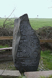
At Meisenbach, the three-mansion stone Meisenbach used to stand between Kurköln , the Duchy of Berg and the County of Sayn . A memorial commemorates the boundary stone, which has since been destroyed.
In 1796 the battle of Kircheib took place near Meisenbach .
In 1910 there were the households Agnes Becker, Ackerer Gottfried Becker, Anna Broich, Ackerer Theodor and Wilhelm Broich, Ackerer Anton Klein, two Matthias Klein, one factory worker and one without a trade, Ackerer Johann Müller, Landlord Bertram Pesch, Ackerer Wilhelm Pick in Meisenbach , two Johann Schellbergs, a day laborer and a dealer, farm worker Wilhelm Schmahl, farm worker Johann Christian Schmitz, farm worker Peter Schmitz and day laborer Peter Sterzenbach.
Until August 1, 1969, Meisenbach belonged to the community of Uckerath , as part of the municipal reorganization of the Bonn area , Uckerath, and thus also the town of Meisenbach, was assigned to the then new non-official community "Hennef (Sieg)".
Individual evidence
- ^ Hennef: Housing directory , residents ' registration office of the city of Hennef
- ^ Population register Siegkreis 1910


