Battle of Kircheib
| date | June 19, 1796 |
|---|---|
| place | near Kircheib, Buchholz and Uckerath in the Westerwald |
| output | Austrian victory |
| Parties to the conflict | |
|---|---|
| Commander | |
| Troop strength | |
| 24,000 | 14,000 |
| losses | |
|
1,500 |
400 |
First Coalition War (1792–1797)
Verdun - Thionville - Valmy - Lille - Mainz (1792) - Jemappes - Namur - Neerektiven - Mainz (1793) - Famars - Valenciennes (1793) - Arlon (1793) - Hondschoote - Meribel - Avesnes-le-Sec - Pirmasens - Toulon - Fontenay-le-Comte - Cholet - Lucon - Trouillas - Menin - Wattignies - Biesingen - Kaiserslautern (1793) - First Battle of Weissenburg (1793) - Second Battle of Weissenburg (1793) - Boulou - Tourcoing - Tournay - 13th Prairial - Fleurus - Vosges - Aldenhoven - San-Lorenzo de la Muga - Genoa - Hyeres - Handschuhsheim - Mainz (1795) - Loano - Montenotte - Millesimo - Dego - Mondovi - Lodi - Borghetto - Castiglione - Mantua - Siegburg - Altenkirchen - Wetzlar - Kircheib - Kehl - Kalteiche - Malsch - Neresheim - Deining - Amberg - Würzburg - Rovereto - Bassano - Limburg - Biberach I - Emmendingen - Schliengen - Arcole - Fall von Kehl - Rivoli (1797) - St. Vincent - Diersheim - Santa Cruz - Neuwied - Camperduin
The Battle of Kircheib was a military conflict in the Revolutionary Wars . On June 19, 1796, the French and Austrian troops met at Kircheib in the Westerwald . The conflict is sometimes referred to as the Battle of Uckerath , after the nearby town of Uckerath , which today belongs to Hennef .
prehistory
In 1796, the French troops led a major campaign in the Westerwald under General Jean-Baptiste Kléber . A field camp was set up on Bergsporn Jungeoth, which today belongs to Buchholz . Several factors made this position particularly suitable. It was of course secured by slopes on three sides as well as the Hanfbach and the Scheussbach . In addition, the Steiner Berg , Priesterberg and Heppenberg, suitable as spying posts , as well as the Hohe Strasse from Cologne to Frankfurt were nearby. The camp was extensively fortified with protective walls and trenches. From June 4, 1796, the French army moved from here to combat. In the Battle of Altenkirchen there was a victory with which the Austrians (under the command of Prince Ferdinand Friedrich August von Württemberg ) were pushed back behind the Lahn . On June 15, however, the French were defeated by the Austrians at Wetzlar under the command of Archduke Karl of Austria and withdrew to their camp. The retreat to Düsseldorf was planned for the next few days .
Course of the battle
The Austrians under Field Marshal Lieutenant Paul Kray attacked the French camp in Jungeoth (near Buchholz / Uckerath ) with cavalry and infantry on June 19, 1796 at two o'clock in the morning , but were repulsed and pursued by the French as far as Kircheib . The village was well defended. The French first took artillery fire and then stormed it, again being fired at by Austrian artillery positioned on the heights behind the village. After a long infantry battle over these heights, the French were repulsed and withdrawn. The French troops had left 1,500 dead, while the Austrians lost 400 soldiers.
The Austrians had four battalions in battle , the entire avant-garde , reinforced by line troops up to 14,000 men, the French over 24,000 soldiers. The French reconnaissance made serious mistakes: on the one hand, they reckoned with 44,000 opponents, on the other hand they knew nothing of the stationing on the heights behind Kircheib.
It is less to be excused that the Austrian Lieutenant Field Marshal Kray, when he advanced against Uckerath on the 19th, was not sufficiently reinforced to give him a decided superiority over the French General Kléber . The exhaustion of the troops, the lack of food, the uncertainty as to whether the enemy had already passed completely at Neuwied , finally the wish not to expand too far, are sham reasons that deserve no consideration because it was only a march, in order to obtain assurance from Kléber's total withdrawal from the victory . (Assessment by Archduke Carl of Austria )
Follow-up events
After the fighting, the French began their large-scale retreat. Kléber's army crossed the Sieg near Siegburg on June 20th and arrived in Düsseldorf on the 21st.
Sources and research
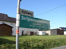
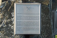
Various contemporary accounts of the battle exist. Among other things, reports and assessments can be found in the records of Archduke Karl of Austria , Austrian Field Marshal Lieutenant Paul Baron Kray von Krajowa and Oberdollendorf's Hermann Christian Hülder, who visited the battlefield on June 20. In addition, numerous artefacts of the battle can still be found in the area and the fortifications in Jungeoth can be seen in aerial photographs. The circumstances of the battle were last examined by the local researchers Horst Weiß and Theo Faßbender from Buchholz. As a result, the Buchholz municipal council had a memorial for peace built on the initiative of council member Ludwig Eich. The inauguration took place on June 19, 2009, the 213rd anniversary of the battle. The memorial stone is located in the Griesenbach von Buchholz district near the village community center in Hohlweg at 50 ° 42 ′ 18.6 ″ N , 7 ° 25 ′ 42.8 ″ E (5 m uncertainty) at the Sophienweiher at 279 m altitude. He lies on a ridge in the middle between the enemy lines at the beginning of the battle. In Griesenbach, on the corner of Buchholzer Strasse, at the corner of Hohlweg, the signs “Village community center / Battle of Kircheib memorial” point the way; from there 700 m straight on. The text board reads:
Here you are standing on historical ground / On Sunday, June 19, 1796, the / “Battle of Kircheib” took place here. It was an event on / the long, difficult path of Europe from / absolutist aristocratic rule to democracy. / French revolutionary troops fought with / with the aim of achieving “freedom, equality and brotherhood” / for all people against armies of / professional soldiers of the absolutist rulers / under the leadership of the German Kaiser. / We commemorate the approximately 2000 soldiers who died in this / battle and the inhabitants of our / country who / had to suffer badly from this war.
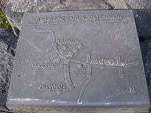
The map board shows the line-up at the start of the battle. The French troops are on the left and the Austrian troops on the right; the site of the monument is in the middle.
literature
- Daniel Schneider: The battle of Altenkirchen 1796 in its historical context . In: Heimat-Jahrbuch des Kreis Altenkirchen , 2012, pp. 183–194.
- 210 years ago: The battle of Kircheib. In: General-Anzeiger (Bonn) of August 30, 2006
- Archduke Carl of Austria : Principles of strategy, explained by the representation of the campaign of 1796 in Germany. Part II History of the Campaign . Anton Strauss, Vienna 1819, pp. 94-101 .
- Jean-Baptiste Jourdan , translated by Johann Bachoven von Echt: Memories of the History of the Campaign of 1796. Coblenz 1823, p. 29 .
- Leopold Bleibtreu : Memories from the war events near Neuwied from 1792 to 1797. Carl Georgi, Bonn 1834, pp. 86–88 (battle near Uckerath)
Individual evidence
- ↑ The left wing of the Armée de Sambre-et-Meuse
- ↑ On the instructions of Commander -in- Chief Jean-Baptiste Jourdan, Kléber's troops were on their way back to their stationing sites in the Bergisches Land
- ↑ Monument commemorates the battle of Kircheib. ( Memento from June 20, 2015 in the Internet Archive ) In: Rhein-Zeitung from November 29, 2011
Coordinates: 50 ° 42 ′ 18.3 " N , 7 ° 25 ′ 42.5" E


