Hanfbach
|
Hanfbach upper course: Irmerother Bach |
||
|
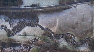
Hennef, Hanfbach, near Lanzenbach, aerial view |
||
| Data | ||
| Water code | DE : 27272 | |
| location | Rhineland-Palatinate and North Rhine-Westphalia , Germany | |
| River system | Rhine | |
| Drain over | Victory → Rhine → North Sea | |
| source | East of the Buchholz -Irmeroth 50 ° 42 '18 " N , 7 ° 25' 37" O |
|
| Source height | approx. 273 m above sea level NHN | |
| muzzle | In Hennef in the Sieg coordinates: 50 ° 46 ′ 25 ″ N , 7 ° 17 ′ 24 ″ E 50 ° 46 ′ 25 ″ N , 7 ° 17 ′ 24 ″ E |
|
| Mouth height | 66 m above sea level NHN | |
| Height difference | approx. 207 m | |
| Bottom slope | approx. 11 ‰ | |
| length | 19 km | |
| Catchment area | 51.495 km² | |
| Discharge at the Geisbach A Eo gauge : 48.9 km² Location: 1.37 km above the mouth |
NNQ (1976-08-26) MNQ 1976/2007 MQ 1976/2007 Mq 1976/2007 MHQ 1976/2007 HHQ (1992-06-20) |
35 l / s 81 l / s 567 l / s 11.6 l / (s km²) 12.7 m³ / s 43.2 m³ / s |
|
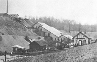
The former Silistria mine produced zinc blende and lead ores in the Hanfbachtal until 1891 . |
||
The Hanfbach is a left tributary of the Sieg . It rises in Rhineland-Palatinate about 800 meters northwest of the village of Griesenbach at about 273 m above sea level. NHN as Irmerother Bach . Near the village of Buchholz -Mendt it unites with the Mendter Bach and from here bears the name Hanfbach . It flows into Hennef at a height of 66 m . Its length is over 19 km, of which 13.6 km flow into North Rhine-Westphalia . The Hanfbach flows through the Hanfbach nature reserve and tributaries .
Even if the stream used to drive the so-called hemp mill, the name has nothing to do with hemp or hemp cultivation in this area. Researchers assume that the name was derived via hanapha (hanafa) from the Germanic hanan (singing, sounding) and apa (river, water), which could have meant something like sounding river . Indeed, when it rains heavily, the Hanfbach turns into a torrential body of water and the difference in altitude from the source to the mouth is also quite considerable at approx. 207 m over 13 km.
In addition, the name of the city of Hennef is derived from this brook. The place used to be called Hannafo .
The villages are also located in the 51 km² water catchment area of the Hanfbach
- Buchholz with the districts of Mendt, Kölsch-Büllesbach , Griesenbach , Krautscheid , Irmeroth, Jungeroth, Hammelshahn, Seifen, Werthenbruch and Priesterberg (all Rhineland-Palatinate )
- Hemp , Köschbusch , Eulenberg , Knipp yaw Scheid , Scheurenstraße , Hove , Uckerath- , Hollenbach Busch , Hüchel , Heckelberg , Derenbach , Wiersberg , Hermes mill , re sound , Kurscheid , Westerhausen , Hofen , Kurenbach , Rütsch , cake Bach , Lanzenbach , Hommerich , thief , Theis Hohn , Michel Hohn , Petershohn , Geisbach , Kümpel , Söven , Wippenhohn and Edgoven of the city of Hennef , as well as the districts of Eudenbach , Schnepperoth, Willmeroth , Bennerscheid and Kotthausen of the city of Königswinter (all North Rhine-Westphalia )
Catchment area and tributaries
The catchment area of the Hanfbach is 51.495 km² and drains into the North Sea via Sieg and Rhine.
|
Stat. in km |
Surname | GKZ | location | Length in km |
EZG in km² |
Mouth |
|---|---|---|---|---|---|---|
| 17.6 | Oberscheider Bach (Source: Druden-Born ) | 27272-114 | Left | 1.052 | Mendt | |
| 17.5 | Mendter Bach | 27272-12 | right | 1.557 | 1.227 | Mendt |
| 17.4 | Steinberg Bach | 27272-132 | right | 1.113 | ||
| 15.2 | Buchholzer Bach (Liesbach) | 27272-14 | Left | 1.031 | ||
| 14.8 | Louisengraben | 27272-152 | right | 1.473 | ||
| 14.6 | Solbach | 27272-16 | Left | 1.86 | Soap | |
| 14.2 | Krautscheider Bach | 27272-172 | right | 1.129 | Soap | |
| 13.7 | Krummenaster Bach | 27272-18 | Left | 2.228 | 2.104 | Soap |
| 13.3 | N. N. | 27272-1912 | Left | 0.959 | ||
| 12.8 | Wertebach | 27272-192 | right | 2.006 | Kotthausen | |
| 11.8 | Eudenbach | 27272-2 | Left | 4.099 | 3.233 | hemp |
| 10.5 | N. N. | 27272-312 | right | 1.035 | ||
| 10.5 | Dollenbach | 27272-32 | Left | 3.055 | 2.187 | Hemp mill |
| 10.3 | Eulenbach | 27272-392 | right | 1.536 | ||
| 9.4 | Müferpützbach | 27272-394 | Left | 2.06 | Dahlhausen | |
| 9.4 | Scheussbach | 27272-4 | right | 5.004 | 5.876 | Dahlhausen |
| 8.3 | Derenbach | 27272-6 | right | 3.93 | 3.149 | |
| 7.9 | N. N. | 27272-712 | Left | 1.321 | ||
| 6.9 | Mokelbach | 27272-714 | right | 0.886 | Röttgen | |
| 5.7 | Westerhausen brook | 27272-72 | Left | 1.909 | 2.022 | Kurenbach |
| 4.4 | Kuchenbach | 27272-732 | right | 1.693 | ||
| 4.2 | Rosental Bach | 27272-74 | Left | 2,455 | 2.188 | Lanzenbach |
| 3.1 | Ingenbach | 27272-76 | Left | 1.141 | 0.672 | |
| 1.4 | Höhner Bach | 27272-8 | right | 4.369 | 3.467 | |
| 1.2 | Lüppichsbach | 27272-92 | Left | 2,329 | Hennef |
Notes on the table
- ↑ Water code number , in Germany the official river code number with a separator inserted after the prefix for better readability, which stands uniformly for the Hanfbach receiving water that is common to all .
Individual evidence
- ↑ Map service of the landscape information system of the Rhineland-Palatinate nature conservation administration (LANIS map) ( notes )
- ^ German basic map 1: 5000
- ↑ a b Water directory of the State Office for Nature, Environment and Consumer Protection NRW 2010 (XLS; 4.67 MB) ( Notes )
- ^ Topographical Information Management, Cologne District Government, Department GEObasis NRW
- ↑ German hydrological yearbook Sieg / Geisbach 2007 ( Memento of the original from March 4, 2016 in the Internet Archive ) Info: The archive link was inserted automatically and has not yet been checked. Please check the original and archive link according to the instructions and then remove this notice. (PDF, 22.9 kB)
- ↑ Nature reserve “Hanfbach and tributaries” in the specialist information system of the State Office for Nature, Environment and Consumer Protection in North Rhine-Westphalia

