Happily
|
Happily
City of Hennef (Sieg)
Coordinates: 50 ° 47 ′ 54 ″ N , 7 ° 18 ′ 0 ″ E
|
||
|---|---|---|
| Height : | 202 m | |
| Residents : | 1447 (Jan 2020) | |
| Incorporation : | October 1, 1956 | |
| Incorporated into: | Lauthausen | |
| Postal code : | 53773 | |
| Area code : | 02242 | |
|
Location of Happerschoss in North Rhine-Westphalia |
||
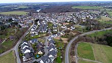
Happerschoss [ -ʃɔs ] is a district of the city of Hennef (Sieg) in the Rhein-Sieg district in North Rhine-Westphalia . Until 1956, Happerschoss was an independent municipality.
history
The place was first mentioned in 1054 as haberscozze . From today scozze ending formed -schoß based as in the neighboring towns on the situation on a promontory. In 1384 the wisdom of the "Freigericht Happerschoß" for the area of honors is mentioned.
During the Thirty Years' War , Happerschoß was sacked by Swedish troops and plundered by French troops on October 28, 1672. The last and largest visitation took place on August 11, 1807, when a large fire destroyed the Church of St. Remigius, 36 houses and 24 barns, built under Archbishop Anno II . Only a few sacred objects from the church could be saved. The Grand Duchy of Berg did not advocate building a new church ; a merger with the Bödingen parish was planned. Thanks to the parish's own initiative and with the support of the District Administrator Freiherr Maximilian von Loë , a new church building could officially be started on August 18, 1818. Construction was completed on December 12, 1818.
Happerschoss community
After the treaties concluded at the Congress of Vienna , the region came to the Kingdom of Prussia . Under the Prussian administration the community Happerschoß was the administrative district of the mayoralty Lauthausen assigned to that part of the circle Uckerath in Cologne Region was. After the Uckerath district was dissolved (1820), the Happerschoss community became part of the Siegburg district (renamed Siegkreis in 1825 ).
In 1885 the community consisted of two other districts in addition to Happerschoss: Bröl and Heisterschoss . There were 195 residential buildings (including uninhabited) with 180 households in the municipality. 927 inhabitants (479 men and 448 women) lived there. All citizens were Catholic at the time, the community had its own parish church.
In 1885 the community had an area of 902 hectares , of which 477 hectares were arable, 66 hectares were meadows and 316 hectares were forest. Today the area belongs to the city of Hennef .
On October 1, 1956, the community of Happerschoss was assigned to the then newly formed community Lauthausen. As part of the municipal reorganization of the Bonn area , the unofficial community Lauthausen was also dissolved on August 1, 1969, Happerschoss was assigned to the simultaneously newly formed community Hennef (Sieg).
Population development
| year | Residents |
|---|---|
| 1816 | 712 |
| 1843 | 856 |
| 1871 | 832 |
| 1905 | 855 |
| 1950 | 1,076 |
traffic
Landesstraße 352 leads past Happerschoß.
Attractions
Happerschoss can be used as a starting point for hikes to the Wahnbachtalsperre . Happerschoss is located at the end of a ridge and offers a wide view to the south towards the Westerwald, to the west towards the Siebengebirge and to the northwest to the Rhenish Bay. There is also a planetary path in the direction of Heisterschoß , starting at the football field.
Individual evidence
- ^ Hennef: Housing directory , residents ' registration office of the city of Hennef
- ^ Adolf Bach : German onomastics. The German place names I, Heidelberg 1953, §291
- ^ The Rhein-Sieg-Kreis . Publisher: Senior District Director Paul Kieras. Stuttgart 1983, p. 271.
- ↑ a b Community encyclopedia for the Kingdom of Prussia from 1885
- ↑ Law on the incorporation of parts of the municipality of Braschoss into the city of Siegburg and the amalgamation of the municipalities of Altenbödingen, Happerschoss, Lauthausen and part of the municipality of Braschoss to form a new municipality. July 10, 1956; § 2 - Published in the Law and Ordinance Gazette for the State of North Rhine-Westphalia , Edition A, 10th year, published in Düsseldorf on July 20, 1956, number 37, p. 192; PDF file
- ^ Law on the local reorganization of the Bonn area (Bonn Law) of July 1, 1969; Sections 15 and 16
- ↑ Census results from 1816 to 1970 of the cities and municipalities . Contributions to the statistics of the Rhein-Sieg-Kreis, Vol. 17 / Siegburg 1980, pp. 46–47.


