Lahnkopf
| Lahnkopf | ||
|---|---|---|
| height | 624.6 m above sea level NHN | |
| location | at Lahnhof ; District of Siegen-Wittgenstein , North Rhine-Westphalia ( Germany ) |
|
| Mountains | Rothaar Mountains | |
| Dominance | 0.73 km → Stiegelburg | |
| Notch height | 13.7 m ↓ immediately southwest | |
| Coordinates | 50 ° 53 '45 " N , 8 ° 14' 45" E | |
|
|
||
| particularities | Lahnquelle ( Lahntopf ) | |
The Lahnkopf near Lahnhof in the Siegen-Wittgenstein district , North Rhine-Westphalia , is 624.6 m above sea level. NHN high side knoll of the Stiegelburg ( 637.8 m ) in the Rothaar Mountains .
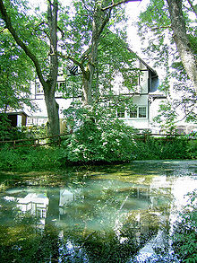
The Lahnkopf is of national importance through the Lahn spring ( Lahntopf ).
geography
location
The Lahnkopf rises in the southern part of the Rothaargebirge in the Sauerland-Rothaargebirge Nature Park a little south of half the air line between Netphen in the west-northwest and Bad Laasphe in the east-northeast. Its summit is located around 2.5 km south-southwest of Großenbach (district of Bad Laasphe) and 2.7 km east -south- east of Walpersdorf and 3.5 km northeast of Werthenbach (district of Netphen). Directly to the south-south-west lies Lahnhof, a district of the Nenkersdorf district of Netphen .
The Lahnkopf is forested, although an open space with fields and meadows extends from its summit region to the neighboring Stiegelburg mountain ( 637.8 m ) to the southwest . The northern neighboring elevation is the gray grove (approx. 638 m ).
Natural allocation
The Lahnkopf belongs to the natural spatial main unit group Süderbergland (No. 33) in the main unit Rothaargebirge (with Hochsauerland ) (333) and in the subunit Dill-Lahn-Eder source area (333.0) to the natural area Ederkopf-Lahnkopf-Ridge (333.01), whereby its western flank in the main unit Siegerland (331) belongs to the sub-unit Siegerland Rothaar-Vorhöhen ( Siegquellbergland ; 331.2).
Spatial information
- Area size: 4.56 km²
- Easting center point: 34 ° 50 '
- High value center: 56 ° 36 '
- Location: Topographic map TK25, no.5115
Watershed, source of the Lahn and flowing waters
The neighboring mountains Lahnkopf and Stiegelburg lie on the watershed between Lahn and Sieg . The water of an approximately 800 m long brook, which rises a little north of the Lahnkopf and flows past the Rehbachswiese , reaches the Rhine through the Lahn . Opposite this flows that of the Werthenbach (also called Lützelbach ), which rises on the Stiegelburg south flank, through the Sieg into the Rhine.
Almost 500 m south-southwest of the Lahn head summit and about 430 m northeast from that of the neighboring mountain Stiegelburg where the hamlet Lahnhof is, is the Lahn source as the origin of Lahn. At the former forester's house Lahnhof (now a hotel and restaurant) it flows from the Lahntopf spring pond between trees (approx. 603 m ).
The larger neighboring springs of the Lahn include the Siegquelle , which is located around 3 km further north, and the Ederquelle , which is around 5 km north-northwest on the Ederkopf . The small source of the Lahn tributary Ilm is located at the Grauhain .
Protected areas
The Lahnkopf lies in the landscape protection area of the community of Netphen ( CDDA no. 321048; designated 1987; 117.6 km² in size). The fauna-flora-habitat area Rothaarkamm and Wiesentäler (FFH no. 5015-301; 34.46 km²) extends east of the summit region .
Traffic and walking
The Eisenstrasse of the Rothaargebirge leads over the high elevations of the neighboring mountains Lahnkopf and Stiegelburg between Großenbach in the north and Hainchen in the south-southwest , which shares the route with the state road 722. At the Lahntopf, this street, which is located directly above the source pond at a height of 605.6 m , and the parallel Rothaarsteig crosses the European long-distance hiking trail E1 .
Individual evidence
- ↑ a b c d Topographical Information Management, Cologne District Government, Department GEObasis NRW ( information )
- ↑ Heinz Fischer: Geographical Land Survey: The natural spatial units on sheet 124 Siegen. Federal Institute for Regional Studies, Bad Godesberg 1972. → Online map (PDF; 4.1 MB)
- ↑ Map services of the Federal Agency for Nature Conservation ( information )

