
Siegerland Red-haired Vorhöhen
| Siegerländer Rothaar-Vorhöhen (Siegquellbergland) | |||
|---|---|---|---|
| Systematics according to | Handbook of the natural spatial structure of Germany | ||
| Greater region 1st order | Low mountain range threshold | ||
| Greater region 2nd order | Rhenish Slate Mountains | ||
| Main unit group | 33 → Süderbergland |
||
| About main unit | 331 → Siegerland |
||
| Natural space |
331.2 → Siegerländer Rothaar-Vorhöhen (Siegquellbergland) |
||
| Geographical location | |||
| Coordinates | 50 ° 55 '22.8 " N , 8 ° 10' 26.4" E | ||
|
|||
| local community | Netphen | ||
| circle | Siegen-Wittgenstein | ||
| state | North Rhine-Westphalia | ||
| Country | Germany | ||


The Siegerländer Rothaar-Vorhöhen natural area , also called Siegquellbergland , is a natural spatial unit with the order number 331.2 within the Siegerland (331). It lies entirely in the Siegen-Wittgenstein district of North Rhine-Westphalia .
geography
location
The Siegerland Rothaar Vorhöhen are located near the core town of Netphen in the Sauerland-Rothaargebirge Nature Park and meet east to northeast at the southern end of the Rothaargebirge .
The natural area extends almost exclusively in the city of Netphen ; Outside of the natural area are the Netphener districts Eckmannshausen , Oelgershausen , Herzhausen , Unglinghausen and Dreis-Tiefenbach . Its northern part extends in the areas of Ruckersfeld , Oechelhausen and Lützel into the urban area of Hilchenbach .
The outer boundary of the natural area runs roughly from the city center of Netphen to the north in the direction of the Hilchenbach district of Ruckersfeld, then east to the Hilchenbach district of Lützel and south-southeast to the Netphener Forsthaus Hohenroth . Then it leads east-southeast towards the Bad Laaspher district of Großenbach , near which it passes the Siegquelle . Then the border runs past the source of the Lahn southwards to the Jagdberg and over its western highlands. Then it leads southwest towards the Netphen district of Hainchen and ultimately southwest past the Netphen district of Deuz towards the northwest to the city center.
Natural allocation and neighbors
The Siegerländer Rothaar-Vorhöhen ( Siegquellbergland ; No. 331.2) are a sub-unit of the main unit Siegerland (331), which belongs to the natural spatial main unit group Süderbergland (33 ).
Neighboring units in natural space are ( viewed clockwise ):
- Southern Siegener Bergland (331.04) in the south-west, Northern Siegener Bergland (331.01) in the west to the north-west and Hilchenbacher Winkel (331.1) in the north-north-west; they all also belong to the main unit Siegerland (331).
- Lützeler Pass (333.13) in the north-north-east, Ederkopf-Lahnkopf-ridge (333.01) in the north-east and east as well as cold oak (with Haincher Höhe ) (333.00) in the south-east; they all belong to the main unit Rothaargebirge (with Hochsauerland) (333).
Altitude and mountains
The Siegerland Rothaar Vorhöhen lie at heights of about 270 m in the southwest to a good 630 m above sea level. NHN in the northeast. The mountainous terrain of the natural area rises in stages: in the south-west, the peaks rise only to around 400 m to 500 m , while in the north-east they rise from 500 m to over 630 m .
The following mountains can be found in the Siegerland Rothaar Vorhöhen or in adjacent landscapes:
Five columns of the table, sorted in descending order of height in meters (m) above sea level in the initial view , can be sorted by clicking on the symbols next to their headings.
Column explanations:
Mountain , elevation, foothills:
In this column, alternative names are put in brackets, in small print and in italics . Elevations thatdo not represent mountains intheirown rightdue to their dominance and prominence are marked with the abbreviation “Nk” = side knoll, and the mountain whose foothills they represent is also mentioned there.
Summit location in natural space ; Adjacent natural area and no. / no .:
In this column, the neighboring natural area unit is named in which the summit is located, if it is not within the Siegerland Rothaar Vorhöhen or on its outer border. In addition, (other) adjacent natural areas are mentioned there.
The corresponding natural area number (s) is / are listed in the column on the right.
Location:
In this column, in the case of an object with at least two municipalities listed, the municipality (s) in whose area the summit is located (if it is not exactly on the border) is / are printed in bold .
Abbreviations:
The abbreviations used in the table below explains:

.jpg)
.jpg)


Abbreviations:
- AT = lookout tower
- Gi = summit location in the neighboring natural area
- Ko = core town (main town) of a municipality / city - see also core town
- m = height in meters (m) above sea level (sea level; unless otherwise stated, according to what is mentioned in the column header)
- n = near (near)
- Nk = side dome
- No./No. = Number / numbers (stands for natural space / spaces)
- NSG = nature reserve
- Q = source
Waters
By far the longest flowing water of the Siegerland Rothaar-Vorhöhen is the Sieg (155.2 km), which flows approximately on the eastern edge of the natural area of the Siegquelle and whose upper course flows through the natural area. The largest still water is the centrally located Obernautalsperre (0.86 km² ).


The waters of the Siegerland Rothaar Vorhöhen are:


Rivers:
The following rivers originate in the Siegerland Rothaar Vorhöhen or flow through the natural area:
Still waters:
The following still waters (reservoirs and ponds) are in the Siegerland Rothaar Vorhöhen:
-
Obernautalsperre on the Obernau
- Reservoir Nauholz am Nauholzbach (in the Nauholz district )
- Pre-barrier Obernau an der Obernau (in the Brauersdorf district ; near the Obernau district )
- Afholderbacher Weiher on the Netphe
- Sohlbacher Weiher on the Hohen Netphe (upper reaches of the Netphe)
geology
The rock of the Siegerland red-haired foothills comes from the Devonian and is divided into the two subspecies Upper Siegen Strata and Lower Siegen Strata . Only in the edge area to the Ederkopf-Lahnkopf-Ridge is the layer of Ers (which also belongs to the Devonian) , unstructured.
climate
The Siegerland Rothaar Vorhöhen have a much rougher climate than the Siegen valley basin. Depending on the altitude, the annual rainfall is between 1000 liters in the southwest of the natural area and up to 1500 liters in the windward direction of the Rothaargebirge in the vicinity of the Hohenroth forest house. The temperature is also relatively low with an average of only around 6 to 7 ° C on the heights and around 8 to 9 ° C in the valleys, especially along the iron road.
Protected areas
A large part of the Siegerland Rothaar Vorhöhen is located in the landscape protection area Netphen ( CDDA no. 390136; designated 1985; 118.9074 km² in size). In the natural area there are also four nature reserves , two of which are in the border area: NSG Auenwald (CDDA no. 162262; 1985; 14.18 ha ) on the Sieg between Netphen and Deuz, the two NSGs Birkenborn, Sinderbach ( CDDA no.162429; 1957; 7.84 ha) and Birkenborn, Fl Judgment Eckstein (CDDA no.162428; 1957; 6.88 ha) near the Sindernbach, as well as the NSG Rothaarkamm and Wiesentäler (CDDA no ; 8.9236 km²), which is close to the Eisenstrasse. Parts of the fauna-flora-habitat area Rothaarkamm and Wiesentäler (FFH No. 5015-301; 34.4146 km²) are also located in the natural area.
Attractions

The sights of the Siegerland Rothaar-Vorhöhen include:
- Nenkersdorf watermill
- Hainchen moated castle
- Obernautalsperre
- Forsthaus Hohenroth
- Iron Road of the Rothaargebirge
- Wall systems on the old castle
Traffic and walking
The federal road 62 , the state roads 729 and 722 (the latter with the iron road of the Rothaargebirge ) run through the natural area . The Rothaarsteig long-distance hiking trail leads along the natural border with some access routes from the Netphen villages. In the future (end of 2016) the Natursteig Sieg will also lead through the natural area.
As circular routes there are also the Dilldappenwanderweg near Hainchen, the Köhlerpfad near Walpersdorf and the Netphener Keltenweg (as one of the hiking highlights on the left and right of the Rothaarsteig ), as well as the soil nature trail at the Hohenroth forester's lodge and the Siegquelle forest adventure path , both of which are in the border area to the adjacent natural area of the Ederkopf -Lahnkopf lie back .
gallery

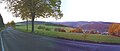
View from the beautiful view at the Eisenstrasse of the Rothaargebirge to the west over the Siegerland Rothaar-Vorhöhen
View from the northwest slope of the Haincher Höhe ; u. a. with the Pfarrbergskopf (left behind)

.jpg)
References and comments
- ↑ a b c Heinz Fischer: Geographical Land Survey: The natural spatial units on sheet 124 Siegen. Federal Institute for Regional Studies, Bad Godesberg 1972. → Online map (PDF; 4.1 MB)
- ↑ a b c Topographical Information Management, Cologne District Government, Department GEObasis NRW ( information )
- ↑ a b c d Map services of the Federal Agency for Nature Conservation ( information )
- ↑ a b Location in the Lahn-Dill district ( Hesse )
- ↑ For a better overview, a hyphen is added to the water code number (GKZ) for each river after the number “272”, which stands for victory .