
Netphener Keltenweg
| Netphener Keltenweg | |
|---|---|
_2.JPG) Information board on the Keltenweg |
|
| Data | |
| length | approx. 15.1 km |
| location | South Westphalia |
| Markers | jagged white line in a circle on a black background (logo of the hiking highlights to the left and right of the Rothaarsteig ) |
| Start / finish point | Netphen (at the Leimbachtal car park) |
| Type | Circular hiking trail |
| Height difference | 560 m |
| The highest point | Old Castle ( 633 m above sea level ) |
| Lowest point | Eschenbach ( 330 m above sea level ) |
| Level of difficulty | normal |
| season | all year round (in a storm there is a risk of branch breakage in the summit area of the Alte Burg) |
| Viewpoints | Old castle, view from the Scharn |
| particularities | Ramparts of the old castle, wooden Celtic figure |
The Netphener Keltenweg is a 15.1 km long circular hiking trail near Netphen, in the North Rhine-Westphalian district of Siegen-Wittgenstein .
Information boards and mascots
On five different information boards along the Celtic Path (one is e.g. on the Old Castle ), the Netphener Celtic family (drawings) devised by the Netphener author and cartoonist Matthias Kringe explains how the Celts lived in the past. There is also a life-size wooden celt at the Afholderbach rest area .
Waymarking

There are two signposts for the Netphener Keltenweg. The more prominent marking is hiking highlights to the left and right of the Rothaarsteig , where the Netphener Keltenweg is one of the 12 circular hiking trails. The second waymarking is a colored logo with the written Netphener Keltenweg. The latter is not often found along the way, as it favors wide farm roads. On the other hand, HikingHighlights prefers a route through the shady forest with many markings. In some places, both path markings use the same route sections so that multiple changes are possible.
The information sign for the Old Castle is not on the route to WanderHighpunkte. If you want to experience this in person, you have to walk approx. 25 meters a short branch route after the logo Netphener Keltenweg.
course
From the Leimbachtal parking lot on the outskirts of Netphen there is a large information board showing the route of the hiking highlights. A wide path starts from the parking lot - this can be followed completely to the second information board. The HikingHighlights route takes a short shortcut: at the first turn to the right, simply continue straight ahead over a narrow dirt road.
Starting out, the Netphener Keltenweg leads past a life-size wooden cigarette over a small ridge, on which, among other things, a ring wall system from Carolingian times is hidden, into the valley of the Netphe tributary of Mühlenbach. Always along this it runs up to the summit of the Knöpfchen mountain ( 526 m ), from where you have a good view to the southwest through the branches of the trees. The path then climbs to Homerich ( 546 m ). From there the Keltenweg leads down to Afholderbach , where the Netphe is crossed. The path then climbs gently through the valley of the Afferbach tributary to Netphe, but later steeply. After a total of about 8 kilometers you have reached the old castle.
There a now narrow path overcomes the outer and inner ring wall and after a further kilometer you have reached the summit of the old castle at a height of 633 meters . Just below this there is a small viewing platform on the inner ring wall. A little further there is a steep descent over the scenic Schüffel to the Scharn ( 496 m ). The further descent takes place through the valley of the Eschenbach to the place of the same name Eschenbach , where the lowest point of the path is at a height of approx. 330 meters. On the opposite side of the valley there is another ascent to the Schießberg. After descending into the Leimbachtal, the path leads parallel to it back to the hikers' car park.
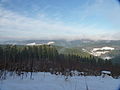
View from the old castle towards Kindelsberg
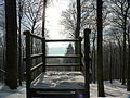
Viewing platform on the inner ring wall of the old castle
_1.JPG)
_3.JPG)
Wegart
Route types in percent:
- Composite ceiling: 23.3%
- Fixed: 49.5%
- Nature trails: 27.2%
literature
- Ulrike Poller, Wolfgang Todt: Tour 8: Netphener Keltenweg. Visit to the Celts. In: Hiking highlights to the left and right of the Rothaarsteig - 16 selected themed circular hiking trails . Idea-Media, 2013, ISBN 978-3-942779-08-1 , p. 74–83 (official Siegerland-Wittenstein hiking guide).
Web links
- siegen-wittgenstein.info/… - General information page
- siegen-wittgenstein.info/… - map including download as GPX or KML
- wittgensteiner-wanderland.de/… - PDF flyer (708 KB)
- nrw-tourismus.de/… - hiking highlights (including Netphen)
- openstreetmap.org/… - Route hiking highlights Netphener Keltenweg
Individual evidence
- ↑ a b c Ulrike Poller, Wolfgang Todt: Tour 8: Netphener Keltenweg. Visit to the Celts. In: Hiking highlights to the left and right of the Rothaarsteig - 16 selected themed circular hiking trails . Idea-Media, 2013, ISBN 978-3-942779-08-1 , p. 74–83 (official Siegerland-Wittenstein hiking guide).
- ↑ a b Topographical Information Management, Cologne District Government, Department GEObasis NRW ( Notes )
- ↑ ocrho: File: Afholderbach-1-Rastplatz.jpg. In: Wikimedia. May 6, 2020, accessed June 7, 2020 .