
Hiking highlights to the left and right of the Rothaarsteig


The term hiking highlights on the left and right of the Rothaarsteig describes 12 circular hiking trails on both sides of the Rothaarsteig in the Siegen-Wittgenstein district in North Rhine-Westphalia . You are in the Sauerland-Rothaargebirge nature park in the Rothaargebirge , Westerwald and Biggehochland .
Waymarks
The sign of the paths shows a white circle on a black background, inside of which there is a white jagged line that is supposed to represent the outline of a mountain range. In addition, each circular hiking trail has its own signpost.
Overview
The following overview gives the name, location, length and the highest point of the respective circular routes. Three of the trails can also be run in two stages.
| Surname | Course (at / between) |
Length ( km ) |
Highest point ( m above sea level ) |
|---|---|---|---|
| Wittgensteiner Schieferpfad | near Bad Berleburg | 13.6 km | Fredlar (576.2 m) |
| Via Adrina | around Arfeld and Schwarzenau | 20.5 km | Viewing platform at the Heller (540 m) |
| Myths and legends trail | at Bad Laasphe | 11.2 km | 595 m |
| Meander path | between Erndtebrück , Rückershausen and Benfe | 23.0 km | Benfer Ridge (624 m) |
| Hilchenbach calorie path | around the Breitenbachtalsperre | 7.3 km | Rest area on the Dörrhöhe (502 m) |
| Kindelsberg path | around Kredenbach and the Kindelsberg | 14.6 km |
Kindelsberg (618.1 m) |
| Netphener Keltenweg | around Afholderbach and Eschenbach | 15.1 km |
Old Castle (633.0 m) |
| Freudenberg half-timbered path | around Freudenberg , Hohenhain and Mausbach | 11.9 km | 436 m |
| Historical Achenbach circular route | near Achenbach | 11.2 km | Strong Buberg (431 m) |
| On miner's trails | near Wilnsdorf | 15.6 km | 555 m |
| Views-prospects | around Neunkirchen | 38.1 km |
Hohenseelbachskopf (517.5 m) |
| Literature in nature | near Burbach - Niederdresselnorf | 31.4 km | 537 m |
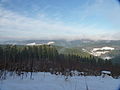
Netphener Keltenweg at the Old Castle with a view towards Kindelsberg
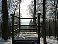
Viewing platform on the inner ring wall of the old castle on the Netphener Keltenweg
_1.JPG)
_3.JPG)
literature
- Ulrike Poller and Wolfgang Todt: Hiking highlights to the left and right of the Rothaarsteig - 16 selected themed circular hiking trails, ideemedia, 2013, ISBN 978-3-942779-08-1
Web links
- nrw-tourismus.de / ... - Overview of hiking highlights
Individual evidence
- ↑ a b c Hiking highlights to the left and right of the Rothaarsteig (see section Literature )
- ↑ Topographical Information Management, Cologne District Government, Department GEObasis NRW ( Notes )