
Wittgensteiner Schieferpfad
| Wittgensteiner Schieferpfad | |
|---|---|
 Signpost of the Wittgenstein Slate Path |
|
| Data | |
| length | approx. 13.6 km |
| location | South Westphalia |
| Markers | black bat on a white background |
| Start / finish point |
Raumland 51 ° 1 ′ 31 ″ N , 8 ° 23 ′ 13.1 ″ E |
| Type | Circular hiking trail |
| Height difference | 423 m |
| The highest point | Fredlar ( 576.2 m above sea level ) |
| Lowest point | ( 400 m above sea level ) |
| Level of difficulty | normal |
| season | all year round |
| Viewpoints | Limburg |
| particularities | Slate rocks, bat tunnels |
The Wittgensteiner Schieferpfad is a 13.6 km long circular hiking trail near Bad Berleburg, in the North Rhine-Westphalian district of Siegen-Wittgenstein . It has been certified as a premium trail by the German Hiking Institute since 2005 . The path was laid out by students from the Bad Berleburg secondary school.
course
Starting from Raumland , the Wittgensteiner Schieferpfad leads past a refuge with a rest area, initially downstream along the Eder towards Laubroth , a district belonging to Dotzlar . A (disused) railway embankment will then be crossed under this section of the route. After crossing the major road 718 ( Bad Berleburg -Dotzlar) and crossing the Meckhäuser Bach extends Wittgensteiner Schieferpfad few meters steeply up a mountain and then through the protected area (NSG) Honert above a disused section of the railway line Bad Berleburg-Allendorf . About a kilometer further, it makes an arc and again leads steeply up the mountain - in serpentines. On this steep section of the route, the route overlaps with that of the Via Adrina , another premium hiking trail.
A little further, the slate path runs through the rock labyrinth of slate rocks Bride and Groom , at the top of which is the Awe bench . Due to the nature reserve, there are trails in the labyrinth: here you have to follow the bat sign or the red dots on the rocks. From the Ehrfurcht bench , the path now leads as a narrow path along the mountain slope of the Honert ( 562.3 m ). Then it runs past a forester's house, through the Meckhäuser Bachtal , and shortly afterwards through the NSG Fredlar . Here the path leads past a disused slate quarry, which is located in the NSG Former Slate Quarry Fredlar . From here you can take a short detour to get to the Wächterstein , one of the four Bilsteine.
Only a few hundred meters further, after a sharp right-hand bend, there is another steep section of the path that leads past the quarry to a 40-meter detour to the foot of the 2nd protected rock of the Bilstein group of rocks (approx. 15-20 meters high) leads. In the further course of the Wittgensteiner Schieferpfad leads over small boulders, past about 10 meter high cliffs (the two other Bilsteins) with seating area to the summit of Fredlar ( 576.2 m ), where it reaches its highest point on a small rock ridge. The descent from there takes place on an old trade route, which is marked here by ruts, into the Steinbachtal . Then he crosses the L 718 at the Auf der Lenne hikers' car park and then runs west of the Limburg ( 578.9 m ) and Hörre ( 566.4 m ) mountains past the Hörre NSG mine area with quarry and bat tunnel , as well as the Drachenstein rock formation , which with a small detour can be made back to Raumland.

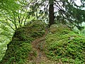
Bank awe on the steep slope on the Wittgensteiner Schieferpfad
On the Wittgensteiner Schieferpfad near Fredlar

Rock formation at Fredlar near Bad Berleburg

One of the Bilsteine on the western slope of Fredlar near Bad Berleburg


Wegart
Route types in percent:
- Composite ceiling: 14.5%
- Fixed: 39.8%
- Nature trails: 45.7%
Raumländer Schieferrevier
Slate used to be mined along the Wittgensteiner Schieferpfad, as can still be seen in some places from the old tunnel entrances, and the path runs through part of the Raumländer slate district .
Bats
10 of 17 bat species documented in the Siegen-Wittgenstein district were found in the Hörre NSG mine area, making the tunnels an important bat roost. The species that have been reliably identified include the fringed bat , the great mouse- eared bat and the small and large whiskered bat .
literature
- Ulrike Poller and Wolfgang Todt: Hiking highlights to the left and right of the Rothaarsteig - 16 selected themed circular hiking trails, ideemedia, 2013, ISBN 9783942779081
- Wandermagazin Pocket Guide hiking highlights left and right of the Rothaarsteig
Web links
See also
Individual evidence
- ↑ a b c d Hiking highlights on the left and right of the Rothaarsteig (see section Literature )
- ↑ Map services of the Federal Agency for Nature Conservation ( information )
- ↑ Topographical Information Management, Cologne District Government, Department GEObasis NRW ( Notes )
- ↑ Species in the NSG pit area Hörre → Flyer NSG Hörre ( Memento from August 22, 2016 in the Internet Archive ) (PDF)