
Obernautalsperre
| Obernautalsperre | |||||||||
|---|---|---|---|---|---|---|---|---|---|
 |
|||||||||
|
|||||||||
|
|||||||||
| Coordinates | 50 ° 55 '3 " N , 8 ° 8' 32" E | ||||||||
| Data on the structure | |||||||||
| Construction time: | 1967-1972 | ||||||||
| Height above valley floor: | 46 m | ||||||||
| Height above foundation level : | 60 m | ||||||||
| Height of the structure crown: | 373.1 m above sea level NHN | ||||||||
| Building volume: | 1,000,000 m³ | ||||||||
| Crown length: | 300 m | ||||||||
| Crown width: | 10 m | ||||||||
| Slope slope on the air side : | 1: 1.90 m | ||||||||
| Slope slope on the water side : | 1: 1.90 m | ||||||||
| Data on the reservoir | |||||||||
| Altitude (at congestion destination ) | 369.7 m above sea level NHN | ||||||||
| Water surface | 86 ha | ||||||||
| Maximum depth | approx. 45 m | ||||||||
| Storage space | 14.8 million m³ | ||||||||
| Total storage space : | 14.9 million m³ | ||||||||
| Catchment area | - 11.3 km² - 21.5 km² (including additional lines) |
||||||||
| Particularities: |
largest dam in the Siegen-Wittgenstein district |
||||||||


The Obernautalsperre is the barrier structure of the 86 hectare Obernau reservoir in the southwest of the Rothaargebirge . It is located in the Brauersdorf district of Netphen in the Siegen-Wittgenstein district , North Rhine-Westphalia ( Germany ).
The still water dammed up here is the larger of the two reservoirs of the Siegen-Wittgenstein water association ; the other or smaller is the Breitenbach dam . The Obernaustausee is used to supply drinking water to nearby towns and to protect against flooding . The towns of Obernau and Nauholz as well as part of Brauersdorf had to give way because they were flooded by the dammed water.
Geographical location
The Obernaustausee is located in Siegerland about 9 km (as the crow flies ) northeast of Siegen and about 2.8 km (as the crow flies) northeast of the city center of Netphens on the southwestern roof of the Rothaargebirge in the Siegerland Rothaar Vorhöhen natural area . It extends immediately east of Brauersdorf , a north-eastern district of Netphen .
The reservoir is dominated by the mountains Alte Burg ( 632.9 m above sea level ), location of a former refuge and cult site from the La Tène period around 500 BC. Chr. , And Sanktkopf ( 606 m ). In addition, there are the mountains Leyberg I ( 512 m ), Scharn ( 496.6 m ), Schüffel ( 540.9 m ), Leyberg II ( 498.9 m ), Kemerling ( 477.4 m ), Nollenkopf around the Obernautalsperre ( 479.1 m ) and a little away from the dam is the Breiter Berg ( 629.2 m ).
The dammed rivers are the small creeks Obernau , which rises between the Alter Burg and Breitem Berg and flows a few kilometers below the dam into the Sieg , which flows in from the east , and the Nauholzbach, which swells near the Hohenroth forest house and flows into the Obernau . There are pre-locks at both tributaries . In addition, a few smaller tributaries flow into the reservoir, including the Burbach.
history
As early as 1931 an expert opinion was drawn up which recommended the construction of dams to secure the drinking water supply in the Siegerland. It was not until more than 20 years later, on September 9, 1953, that the water association was founded. In the same year, the construction of the Breitenbach dam began. The planning for the Obernautalsperre began in 1960, as the dry years 1957 and 1959 had made it clear that a safe supply of drinking water could only be achieved over a large area and that the Breitenbachtalsperre was not sufficient. The towns of Obernau and Nauholz had to give way completely to the Obernautalsperre, the town of Brauersdorf in part. A total of 365 people were relocated (most of them built new homes in the local area). The sidewalks around the Obernautalsperre were laid out in 1966/67 and the concrete structures of the main dam and pre-dam Nauholz were built between 1967 and 1969.
In 1970 the construction of the main dam began. In the fall of 1971, the dam was finished with the asphalt concrete outer seal. Commissioning took place on November 7, 1972 in the presence of the then North Rhine-Westphalian Agriculture Minister Diether Deneke . The dam of the Obernau reservoir was built according to plans by W. Ihssen and G. Salveter. In 1979, the water supply perspective plan was presented, which examines and documents the need up to 2020. He made it clear that in addition to the Breitenbach dam, the Obernaut dam also needed higher performance. In 1984, therefore, bypass tunnels were put into operation to supply water from the catchment area of the upper Sieg.
Technical
Reservoir
The Obernaustausee , whose water surface at the highest storage target ( 369.7 m above sea level ) is 86 ha (0.86 km²), has around 14.8 million m³ of storage space and a catchment area of around 11.3 km². In addition, a bypass tunnel, which was built from 1982 to 1984, connects a catchment area of 10.2 km²; it directs water from the upper Sieg, the Michelbach and the Sindernbach through the Nauholzbach into the dam.
dam
The Obernautalsperre which the 1967-1972 at Netphen as a dam built dam represents the Obernaustausees is a rockfill dam with an asphalt concrete -Außendichtung. The dam has a flood relief with three fish-bellied flaps , a 70 m high extraction tower at the water-side dam foot with six different extraction heights , a hearth wall with a control passage along the entire length of the water-side dam foot and a bottom outlet channel. The dam has two berms on the green air side .
The Obernautalsperre, which is 46 m high above the valley floor (dam crest: 373.5 m above sea level ), 300 m crest length and 10 m crest width, has a dam volume of 1,000,000 m³.
stollen
In addition to water from Obernau, Nauholzbach and other small tributaries, the Obernautalsperre is also fed with water from Sieg , Sindernbach and Michelsbach . That is fed through a tunnel to the Nauholzbach.
The victory tunnel is 2.9 kilometers long and has a gradient of 3%. Its maximum flow rate is 6.7 m³ / s.
The Sindernbach tunnel is 800 meters long and (like the Sieg tunnel) has a gradient of 3%. A maximum of 1.5 m³ / s flow through it.
The Sindernbachstollen merges with the Siegstollen and part of the Michelsbachwasser is fed to the Siegstollen through a vertical shaft. Thanks to a sophisticated system, only enough water is taken from the three bodies of water that a certain amount of water remains in their lower reaches and that the ecological balance is preserved.
Freetime activities
The Obernaustausee is a popular destination. Around the reservoir there is a 9.6 km long circular trail for hiking, cycling (etc.). On the dam, you can find out a lot about the Siegen-Wittgenstein water board and the Obernautalsperre on an information path laid out in 2003 at five stations with signs. There are no other recreational opportunities at the reservoir because of its character as a drinking water reservoir.
See also
photos

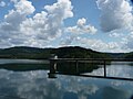
Aerial view of the Obernautalsperre
Obernautalsperre with extraction tower

Dam of the Obernautalsperre

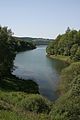
View over the reservoir
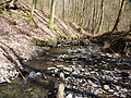
Inflow to the Obernautalsperre
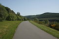
Hiking trail around the reservoir
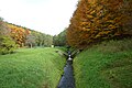
Nauholzbach tributary
Tributary Obernau


.JPG)
Web links
- Siegen-Wittgenstein Water Association (official homepage)
- Nauholz ( Memento from October 11, 2004 in the Internet Archive ) (sunken village)
- Obernautalsperre - Obernau, the sunken village , on brauersdorfer.de
- Dams directory NRW (PDF; 121.1 kB)
- Obernautalsperre at baukunst-nrw
Individual evidence
- ↑ Topographical Information Management, Cologne District Government, Department GEObasis NRW ( Notes )
- ^ "Scrolled back ...", Siegener Zeitung of December 4, 2010
- ↑ Information board on the history of the water board at the dam
- ↑ Information boards at the dam