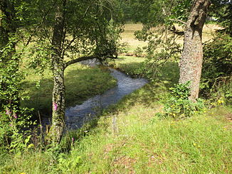
Benfe (Eder)
| Benfe | ||
|
The Benfe near the forester's house Ludwigseck , |
||
| Data | ||
| Water code | DE : 428114 | |
| location | District of Siegen-Wittgenstein , North Rhine-Westphalia ( Germany ) | |
| River system | Weser | |
| Drain over | Eder → Fulda → Weser → North Sea | |
| source | in the Rothaargebirge near Benfe 50 ° 55 ′ 46 ″ N , 8 ° 12 ′ 20 ″ E |
|
| Source height | approx. 620 m above sea level NHN | |
| muzzle | in Erndtebrück in the Eder coordinates: 50 ° 59 ′ 23 " N , 8 ° 15 ′ 22" E 50 ° 59 ′ 23 " N , 8 ° 15 ′ 22" E |
|
| Mouth height | approx. 475 m above sea level NHN | |
| Height difference | approx. 145 m | |
| Bottom slope | approx. 13 ‰ | |
| length | approx. 11.2 km | |
| Catchment area | approx. 19.5 km² | |
| Left tributaries | see below | |
| Right tributaries | see below | |
| Communities | Erndtebrück | |
The Benfe is a 11.2 km long, southern and orographically right tributary of the Eder in the district of Siegen-Wittgenstein , North Rhine-Westphalia ( Germany ).
course
The Benfe rises and runs in the Sauerland-Rothaargebirge Nature Park . Your source is located in the southwest part of the Rothaargebirge about 2.5 km west-southwest of Benfe , a municipality part of Erndtebrück , and about 700 meters south-southwest of the Ederkopf located Eder source . It is located in the forest a little northwest of the summit region of the Rauhen Kopf ( Rauer Kopf ; 640.7 m above sea level ) at an altitude of around 620 m . The Eisenstrasse of the Rothaargebirge leads past a little to the southwest as part of the state road 722 ; The Ederquelle hikers' car park (approx. 655 m ) is located on the road around 560 m west-northwest of the Benfequelle .
The Benfe initially runs - passing the Aukopf ( 644.9 m ) in the north and gradually leaving the wooded area - in an easterly direction to the village of Benfe, around this and also the Jagdberg ( 634.5 m ) in a long left-hand bend to the east; it passes the Weibelskopf ( 620.7 m ) to the east . From then on she runs to the north through a narrow and not very populated valley, where inter alia the forested mountains Supreme Henn ( 675.9 m ) to the west and birch hedge ( 661.1 m ) and Ebschloh ( 686.3 m happened) to the east . In this area, the stream, which has a relatively low gradient and is straightened in sections, forms a few meanders over a stretch of about 2.5 km in the direction of the eponymous core town of Erndtebrück .
Finally, the Benfe reaches the location Erndtebrück, where about 100 m after passing under the federal highway 62 to approximately 475 m height in the zoom from the southwest flowing upper reaches of the Eder (influx of Fulda ) opens . The Benfewasser thus overcomes a height of about 150 m from the source to the mouth, which is located between the Eder river kilometers 164.2 and 164.3 .
Benfebach, below the headwaters and shortly before passing through a fire water pond at the "Katzenwiese"
Catchment area and tributaries
The catchment area of the Benfe is about 19.5 km². Looking downstream, their tributaries include:
| Surname | page | Length ( km ) |
|---|---|---|
| Lützelbach | Left | 1.60 |
| Beierbach | Left | 1.45 |
| Dörnbach | Left | 3.60 |
| Seebach | Left | 3.25 |
| Hackenbracht | Left | 1.10 |
| Bärenbach | Left | 0.90 |
| Rammelsbach | right | 1.50 |
Localities
Villages on the Benfe are (viewed downstream):
Traffic and walking
The state road 720 runs along the Benfe, which runs from the direction of Walpersdorf / Eisenstrasse of the Rothaargebirge through the village of Benfe and then to Erndtebrück; there the stream crosses the federal highway 62 . The upper reaches of the Benfe crosses the Rothaarsteig in Benfe-Waldheim , and the meander path runs along the stream .
Individual evidence
- ↑ Topographic map 1: 25,000
- ↑ a b c d e f Topographical Information Management, Cologne District Government, Department GEObasis NRW ( information )


