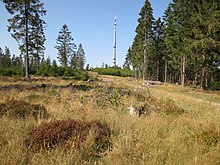
Colonel Henn
| Colonel Henn | ||
|---|---|---|
| height | 676.5 m above sea level NHN | |
| location | near Benfe ; District of Siegen-Wittgenstein , North Rhine-Westphalia ( Germany ) | |
| Mountains | Rothaar Mountains | |
| Dominance | 4.9 km → Ebschloh | |
| Notch height | 95.8 m ↓ from the birch hedge to Ebschloh | |
| Coordinates | 50 ° 56 '38 " N , 8 ° 12' 45" E | |
|
|
||
| particularities | Location of the transmitter Ederkopf ; next to the Jagdberg, the highest mountain in the city of Netphen |
|
The Oberste Henn near Benfe in the North Rhine-Westphalian district of Siegen-Wittgenstein is 676.5 m above sea level. NHN high mountain in the Rothaargebirge and just before the Jagdberg the highest mountain in Netphens. It is the location of the Ederkopf transmitter .
geography
location
The Oberste Henn rises in the southern part of the Rothaargebirge on the border of Siegerland and Wittgensteiner Land in the areas of the city of Netphen , the municipality of Erndtebrück and the city of Hilchenbach and belongs to the Sauerland-Rothaargebirge nature park . Its summit is 2.5 km west-northwest of Benfe (to Erndtebrück) and 4 km (as the crow flies ) south-east of Lützel (Hilchenbach). About 60 m east-northeast of the summit runs the border of the districts Benfe in the east and, with the summit there, Nauholz (Netphen) in the west; The district of Lützel joins around 200 m north of the summit.
About 400 m south of Oberste Henn is the southern branch of the Ederkopf ( 648.8 m ) with the nearby Eder spring and on its northeast slope, about 300 m from the summit, the origin of the Dörnbach, a small western tributary of the Benfe . The geographical center of the Siegen-Wittgenstein district lies at its southwestern foot ; The Rothaarsteig leads directly past there at 592.9 m .
Natural allocation
The Oberste Henn belongs to the natural spatial main unit group Süderbergland (No. 33) in the main unit Rothaargebirge (with Hochsauerland ) (333) and in the subunit Dill-Lahn-Eder source area (333.0) to the natural area Ederkopf-Lahnkopf-Ridge (333.01).
Mountain height
The height of Oberste Henn is often only given as around 674 m , which, however, refers to a trigonometric point ( 674.2 m ; ⊙ ) that is about 90 m southeast of its summit ( 675.9 m ) on a hiking trail .
Protected areas and flora
On the Supreme Henn , parts extend the multipart nature reserve Rothaarkamm and Wiesentäler ( CDDA -No 329599;. Reported in 1930; 11.74 square kilometers in size) and those of the protected landscape areas community Netphen (CDDA No. 321048;., 1987; 117.6 square kilometers) and Rothaargebirge (Siegen-Wittgenstein district) (CDDA no. 555550027; 299.42 km²). In addition, areas of the fauna-flora-habitat area Rothaarkamm and Wiesentäler (FFH no. 5015-301; 34.46 km²) spread out there. In the summit area there are deciduous forest - and otherwise mostly coniferous forest parcels of the Wittgenstein Forest .
Ederkopf transmitter
The 161 m high transmission tower of the Ederkopf transmitter , which is named after the nearby Ederkopf , has stood on Obersten Henn since 1981 . The operator of the broadcasting system for radio and television is Westdeutsche Rundfunk (WDR).
Traffic and walking
Almost 1.8 km (as the crow flies ) southwest of the summit of the Oberste Henn runs with the iron road of the Rothaargebirge ( L 722), one of several former trade and long-distance routes from which you can hike the mountain over the Ederkopf.
Individual evidence
- ↑ a b c Topographical Information Management, Cologne District Government, Department GEObasis NRW ( information )
- ↑ Heinz Fischer: Geographical Land Survey: The natural spatial units on sheet 124 Siegen. Federal Institute for Regional Studies, Bad Godesberg 1972. → Online map (PDF; 4.1 MB)
- ↑ Map services of the Federal Agency for Nature Conservation ( information )


