
Aumenau
|
Aumenau
Market town Villmar
|
|
|---|---|
 |
|
| Height : | 129 (122-231) m above sea level NHN |
| Area : | 6.47 km² |
| Residents : | 1488 (Jun. 30, 2020) |
| Population density : | 230 inhabitants / km² |
| Incorporation : | 1st February 1971 |
| Postal code : | 65606 |
| Area code : | 06474 |
Aumenau is a district of the municipality of Villmar in the Limburg-Weilburg district in Central Hesse .
Geographical location

Aumenau is located on the eastern edge of the Limburg basin , mostly on the right northern bank of the Lahn , four kilometers northeast of the core municipality of Villmar and 13 kilometers east of the district town of Limburg an der Lahn .
The district borders in the south on Langhecke , in the south-west on Villmar, in the north-west on Seelbach and in the north at one point on Falkenbach (all Villmarer districts). Elkerhausen joins in the northeast and Blessenbach in the east (both districts of Weinbach ).
The place itself extends over the slope of the Lahn valley in a knee of the river shaped to the southeast. The northwestern and western residential areas are mainly new development areas that arose after the Second World War. A few houses are on the left bank of the river. Both parts of the village are connected by a road bridge over the Lahn. On the river bank, the site reaches a height of around 122 meters. On the high north-western edge of the village, the last houses are around 160 meters above sea level. Around the valley of the Lahn and the Rissbach which flows out at Aumenau, the terrain rises significantly, with a plateau being formed especially to the west of the place. The subsoil reaches its highest height at 250 meters on the "Steinigen Kopf" in a wooded area on the boundary with Seelbach in the north-west.
The Aumenau district is characterized by several pieces of forest on the peaks of the various mountain ranges and larger contiguous agricultural areas on the more level sections. The western part of the district tends to be dominated by agricultural use, while the forest predominates in the east, which merges into larger forest areas of the Hintertaunus .
history
The place was first mentioned as "Villa Amana" in 764 in a deed of donation to the Fulda monastery and can thus record the earliest first mention in a wide area. At that time, the place probably belonged to a no longer clearly addressable influence unit that had its center in Niederselters . In the 9th century the place was under the influence of the Konradines . In the 14th century, Aumenau itself became the capital of a district court that included Seelbach, Fürfurt, Blessenbach, Laubuseschbach, Wolfenhausen, Münster and Weyer. The place of justice was the chapel and the Nikolaus-Dernbach farm, which were located on today's road to Langhecke, at the entrance to the Rißbach valley. Initially, the center belonged to the County of Diez . In 1366 Count Gerhard VII von Diez pledged Aumenau to the Lords of Runkel , who soon took over the rule. Her successors, the Counts of Wied , owned the place until 1806.
In the Middle Ages, the place consisted of Niederlassungau at the point of today's town center and Oberreckenau, around one kilometer up the Lahn on the left bank in what is now the “Schafstall” area. The place fell desolate in the late Middle Ages . The first verifiable chapel in the village was consecrated in 1510. The Reformation was probably introduced before 1561. From 1624 Aumenau belonged to the parish of Seelbach. The Nikolaus-Dernbach chapel became a ruin at the beginning of the 19th century. In 1819 the old chapel was also considered dilapidated. After repairs, it was demolished in 1854 and a new church was built. The oldest existing church today, a historical building from 1903, belongs to the Protestant parish. In the meantime, the Catholic (built in 1954) and Lutheran parishes each have their own church building . The Lutheran parish has existed since 1817. Its church was built in 1952. Catholics came to the place especially as expellees after the Second World War . They got their own church in 1954. In 1964 the Protestant parish built a parish hall.
The school location was initially Seelbach as the seat of the parish . From 1805 there were school lessons in Aumenau and at the latest in 1819 a permanent building for the school. A school house was built in 1835. The current school was completed in 1912.
In 1862 the place received a train station of the Lahntalbahn , which was shortly followed by a second loading station, which triggered an economic boom. The railway line made the construction of the first Lahn bridge necessary in 1878. The current bridge was built in 1928. In 1907 the place got running water. In 1924 the entire place was connected to the power grid , in 1925 a gymnasium and community hall was built. In 1979 a new cemetery was completed. In 1980 a new sports field was built, in 1989 the "Eichelberghalle" as a community hall next to it, where in 1999 a kindergarten was built.
In the run-up to the regional reform in Hesse , the state government approved the merger of the communities of Aumenau and Villmar in the Oberlahnkreis into one community with the name Villmar with effect from February 1, 1971 .

Catholic Church
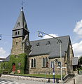
Protestant church

primary school


Territorial history and administration
The following list gives an overview of the territories in which Aumenau was located and the administrative units to which it was subordinate:
- before 1806: Holy Roman Empire , county (since 1791 principality) to Wied-Runkel , office or rule of Runkel
- 1806–1813: Grand Duchy of Berg , Department of Sieg , Canton of Runkel (from 1811 Canton of Hadamar)
- 1813–1815: Principality of Nassau-Orange , Runkel office
- from 1816: German Confederation , Duchy of Nassau , Office of Runkel
- from 1849: German Confederation, Duchy of Nassau, Limburg District Office
- from 1854: German Confederation, Duchy of Nassau, Office of Runkel
- from 1867: North German Confederation , Kingdom of Prussia , Province of Hessen-Nassau , Administrative Region of Wiesbaden , Oberlahnkreis
- from 1871: German Empire , Kingdom of Prussia, Province of Hessen-Nassau, administrative district of Wiesbaden, Oberlahnkreis
- from 1918: German Empire, Free State of Prussia , Province of Hessen-Nassau, Administrative Region of Wiesbaden, Oberlahnkreis
- from 1944: German Empire, Free State of Prussia, Nassau Province , Oberlahnkreis
- from 1945: American zone of occupation , Greater Hesse , Wiesbaden district, Oberlahn district
- from 1949: Federal Republic of Germany , State of Hesse , Wiesbaden district, Oberlahnkreis
- from 1968: Federal Republic of Germany, State of Hesse, administrative district Darmstadt , Oberlahnkreis
- on February 1, 1972, Aumenau was incorporated as a district of the municipality of Villmar.
- from 1974: Federal Republic of Germany, State of Hesse, administrative district Darmstadt, district Limburg-Weilburg
- from 1981: Federal Republic of Germany, State of Hesse, Gießen district, Limburg-Weilburg district
population
Population development
In 1830 there are 330 inhabitants. In 1843 the population consisted of 357 Protestant, six Catholic and 17 Jewish residents. In 1905 there was a population of 654 and in 1939 of 825. Despite the losses caused by the Second World War, the population rose to 1234 people by 1946 due to the influx of displaced persons . In 1970 there were 1252 and by 1987 the number rose to 1,431 inhabitants.
| Aumenau: Population from 1834 to 2020 | ||||
|---|---|---|---|---|
| year | Residents | |||
| 1834 | 375 | |||
| 1840 | 391 | |||
| 1846 | 426 | |||
| 1852 | 486 | |||
| 1858 | 550 | |||
| 1864 | 622 | |||
| 1871 | 602 | |||
| 1875 | 578 | |||
| 1885 | 601 | |||
| 1895 | 654 | |||
| 1905 | 712 | |||
| 1910 | 733 | |||
| 1925 | 825 | |||
| 1939 | 1,234 | |||
| 1946 | 1,235 | |||
| 1950 | 1,199 | |||
| 1956 | 1,207 | |||
| 1961 | 1,252 | |||
| 1970 | 1,252 | |||
| 1980 | ? | |||
| 1990 | ? | |||
| 2000 | ? | |||
| 2011 | 1,488 | |||
| 2012 | 1,493 | |||
| 2015 | 1,537 | |||
| 2020 | 1,488 | |||
| Data source: Historical municipality register for Hesse: The population of the municipalities from 1834 to 1967. Wiesbaden: Hessisches Statistisches Landesamt, 1968. Further sources:; after 1970 Villmar municipality ( web archive ,); 2011 census | ||||
Religious affiliation
Source: Historical local dictionary
| 1885: | 555 Protestant (= 96.02%), 12 Catholic (= 2.08%) and 11 (= 1.90%) Jewish residents |
| 1961: | 1012 (= 83.84%) Protestant and 178 (= 14.75%) Catholic residents |
coat of arms
On June 8, 1964, the municipality of Aumenau in what was then the Oberlahnkreis , Wiesbaden district , was awarded a coat of arms with the following blazon : In green, a silver corrugated rafter, accompanied by three silver flowers with golden lugs (2: 1).
Culture and sights
Cultural monuments
See the list of cultural monuments in Aumenau
societies
The place has a men 's choir (founded in 1862), a women's choir (1907), a gymnastics and sports club (1896), a minstrel and fanfare train (1964), the volunteer fire brigade (1932, since October 5, 1972 with youth fire brigade ), a local and tourist association (1961), a riding and driving association (1989), a Kyffhäuser comradeship (1957), a tennis association (1960) together with Langhecke, the shooting club "Diana" (1963) and a local branch of the VdK .
Infrastructure
The Aumenau volunteer fire brigade , founded in 1932 (with youth fire brigade since October 5, 1972), provides defensive fire protection and general help.
literature
- Literature about Aumenau in the Hessian Bibliography
- Search for Aumenau in the SPK digital portal of the Prussian Cultural Heritage Foundation
Web links
- Districts. In: Website of the municipality of Villmar.
- Aumenau, Limburg-Weilburg district. Historical local dictionary for Hessen. In: Landesgeschichtliches Informationssystem Hessen (LAGIS).
Individual evidence
- ↑ a b c d Aumenau, Limburg-Weilburg district. Historical local dictionary for Hessen. (As of March 23, 2018). In: Landesgeschichtliches Informationssystem Hessen (LAGIS).
- ↑ a b Figures - data - facts, population figures in brief. In: Internet presence. Villmar market town, accessed August 2020 .
- ^ Municipal reform: mergers and integration of municipalities from January 20, 1971 . In: The Hessian Minister of the Interior (ed.): State Gazette for the State of Hesse. 1971 No. 6 , p. 248 , item 328, paragraph 34 ( online at the information system of the Hessian state parliament [PDF; 6.2 MB ]).
- ^ Federal Statistical Office (ed.): Historical municipality directory for the Federal Republic of Germany. Name, border and key number changes in municipalities, counties and administrative districts from May 27, 1970 to December 31, 1982 . W. Kohlhammer GmbH, Stuttgart and Mainz 1983, ISBN 3-17-003263-1 , p. 373 .
- ^ Michael Rademacher: German administrative history from the unification of the empire in 1871 to the reunification in 1990. State of Hesse. (Online material for the dissertation, Osnabrück 2006).
- ↑ Selected data on population and households on May 9, 2011 in the Hessian municipalities and parts of the municipality. (PDF; 1 MB) In: 2011 Census . Hessian State Statistical Office
- ↑ Approval of a coat of arms of the community of Aumenau, Oberlahnkreis, administrative district Wiesbaden from June 8, 1964 . In: The Hessian Minister of the Interior (ed.): State Gazette for the State of Hesse. 1964 No. 25 , p. 774 , point 689 ( online at the information system of the Hessian state parliament [PDF; 4.7 MB ]).