
Greifenstein (Hesse)
| coat of arms | Germany map | |
|---|---|---|
.png)
|
Coordinates: 50 ° 37 ' N , 8 ° 18' E |
|
| Basic data | ||
| State : | Hesse | |
| Administrative region : | to water | |
| County : | Lahn-Dill district | |
| Height : | 437 m above sea level NHN | |
| Area : | 67.42 km 2 | |
| Residents: | 6566 (Dec. 31, 2019) | |
| Population density : | 97 inhabitants per km 2 | |
| Postal code : | 35753 | |
| Primaries : | 02775, 02779, 06449, 06473, 06478, 06477 | |
| License plate : | LDK, DIL | |
| Community key : | 06 5 32 010 | |
| LOCODE : | DE GFS | |
| Address of the municipal administration: |
Herborner Strasse 38 35753 Greifenstein |
|
| Website : | ||
| Mayor : | Marion Sander ( independent ) | |
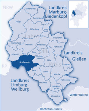
| Location of the community of Greifenstein in the Lahn-Dill district | ||
  |
||


Greifenstein is a municipality in the Lahn-Dill district in central Hesse . Greifenstein with its ten districts covers 67.42 km² on the eastern slope of the Westerwald . It takes its name from the dominant castle ruins in the district of the same name. The seat of the municipal administration is in the district of Beilstein.
geography
Greifenstein extends from approx. 170 m above sea level near Allendorf, where the Ulmbach flows into the district of Leun, up to 605 m above sea level at the junction near the district Arborn. The area is shaped very differently, from partly plains on the heights to steep inclines.
With 51.13% forest area, the community of Greifenstein has the largest proportion of forest in the Hessian communities. This results in high income from forestry for the municipal budget. Mixed forests predominate, but there are also pure districts with conifers.
Greifenstein is drained via the Kallenbach and Ulmbach. Both are fed by a few tributaries from the forests before they flow into the Lahn .
The municipality is rich in natural resources, especially basalt and clay. Iron ore was also mined in the past.
Neighboring communities
Greifenstein borders the municipality of Driedorf in the northwest , the city of Herborn and the municipality of Sinn in the north, the municipality Ehringshausen in the east, the city of Leun (all in the Lahn-Dill district) and the municipality of Löhnberg in the south-west the community of Mengerskirchen (both in the Limburg-Weilburg district ).
structure
Table of the districts of the municipality with population and area. As of December 31, 2017
| Districts | Residents | Area km² |
|---|---|---|
| Allendorf | 1314 | 7.80 |
| Arborn | 599 | 5.46 |
| Beilstein | 1464 | 10.24 |
| Greifenstein | 575 | 9.79 |
| Holzhausen | 818 | 6.55 |
| Nenderoth | 425 | 6.02 |
| Odersberg | 266 | 3.84 |
| Rodenberg | 212 | 2.52 |
| Rodenroth | 407 | 6.61 |
| Ulm | 671 | 8.59 |
| total | 6751 | 67.43 |
history
The first documented mention of Greifenstein Castle dates back to 1237. In 1322, King Ludwig IV granted Count Gottfried von Sayn permission to build a fortified city below the castle with Frankfurt city rights , but Greifenstein was granted city rights without any consequences. The Greifenstein Castle gave the municipality its name, which was founded in 1977 as part of the regional reform in Hesse .
Territorial reform
As part of the regional reform in Hesse , the previously independent communities of Allendorf , Holzhausen and Ulm merged on February 1, 1971 on a voluntary basis to form the new large community of Ulmtal .
On December 31, 1971, the previously independent municipality was Rodenroth and 1 July 1972 Rodenberg also volunteered in the neighboring village of Beilstein incorporated .
Today's large community Greifenstein was created by the law on the reorganization of the Dill district, the districts of Gießen and Wetzlar and the city of Gießen on January 1, 1977 through the merger of the previous communities Greifenstein and Ulmtal from the district of Wetzlar and Arborn , Beilstein , Nenderoth and Odersberg from the Dill district . Local districts with local councils and local councilors were formed for all formerly independent communities . The local part of Beilstein became the seat of the municipal administration.
Historical forms of names
In documents that have been preserved, Greifenstein was mentioned under the following place names (the year it was mentioned in brackets):
- Griffenstein, de (1158) [The reference of this Meribodo by Greifenstein in: RI IV, 2, no. 531 is probably not related to this Greifenstein]
- Griffenstein, de (1237) [Document book of the city of Wetzlar 1, p. 8 No. 24]
- Griffinstein, de (1255) [Document book of the city of Wetzlar 1, pp. 23–24 No. 70 and 74]
Territorial history and administration
The following list gives an overview of the territories in which Greifenstein was located and the administrative units to which it was subordinate:
- before 1806: Holy Roman Empire , Principality of Solms-Braunfels , part of the County of Solms , Greifenstein office
- from 1806: Duchy of Nassau , Greifenstein office
- 1816: Kingdom of Prussia , Rhine Province , Region of Koblenz , county Braunfels
- from 1822: Kingdom of Prussia, Rhine Province, Koblenz District, Wetzlar District
- from 1866: North German Confederation , Kingdom of Prussia, Rhine Province, Koblenz District, Wetzlar District
- from 1871: German Empire , Kingdom of Prussia, Rhine Province, Koblenz District, Wetzlar District
- from 1918: German Empire, Free State of Prussia , Rhine Province, Koblenz District, Wetzlar District
- from 1932: German Empire, Free State of Prussia, Province of Hessen-Nassau , Administrative Region of Wiesbaden , District of Wetzlar
- from 1944: German Empire, Free State of Prussia, Nassau Province , Wetzlar District
- from 1945: American zone of occupation , Greater Hesse , Wiesbaden district, Wetzlar district
- from 1949: Federal Republic of Germany , State of Hesse , Wiesbaden district, Wetzlar district
- from 1968: Federal Republic of Germany, State of Hesse, administrative district Darmstadt , district of Wetzlar
- from 1977: Federal Republic of Germany, State of Hesse, Darmstadt administrative district, Lahn-Dill district
- On January 1, 1977, the communities Ulmtal (with the districts Allendorf, Holzhausen and Ulm) and Beilstein (with the districts Beilstein, Rodenroth and Rodenberg) merged with the towns of Arborn, Greifenstein, Nenderoth and Odersberg to form the new community Greifenstein. The municipal administration is based in Beilstein.
- from 1981: Federal Republic of Germany, State of Hesse, Gießen administrative district , Lahn-Dill district
population
Population development
The State Audit Office of Hesse calculated a population decline of 2,377 inhabitants by 2050 for the community of Greifenstein in October 2010.
| Greifenstein: Population from 1834 to 2015 | ||||
|---|---|---|---|---|
| year | Residents | |||
| 1834 | 527 | |||
| 1840 | 581 | |||
| 1846 | 586 | |||
| 1852 | 556 | |||
| 1858 | 535 | |||
| 1864 | 520 | |||
| 1871 | 476 | |||
| 1875 | 504 | |||
| 1885 | 463 | |||
| 1895 | 512 | |||
| 1905 | 568 | |||
| 1910 | 584 | |||
| 1925 | 647 | |||
| 1939 | 620 | |||
| 1946 | 839 | |||
| 1950 | 792 | |||
| 1956 | 745 | |||
| 1961 | 725 | |||
| 1967 | 930 | |||
| 1970 | 745 | |||
| 1976 | 6,600 | |||
| 1984 | 6,628 | |||
| 1992 | 7,371 | |||
| 2000 | 7,400 | |||
| 2004 | 7,390 | |||
| 2010 | 7,026 | |||
| 2015 | 6,900 | |||
| Data source: Historical municipality register for Hesse: The population of the municipalities from 1834 to 1967. Wiesbaden: Hessisches Statistisches Landesamt, 1968. Further sources:; 1972 :; 1976 :; 1984 :; 1992 :; 2000, 2015 :; 2004 :; 2010: From 1976 including the towns incorporated into Hesse as part of the regional reform . | ||||
Religious affiliation
Source: Historical local dictionary
| 1885: | 510 Protestant, 6 Catholic residents and 11 Mennonites |
| 1961: | 604 Protestant (= 83.31%) and 115 (= 15.86%) Catholic residents |
politics
Community representation
The local elections on March 6, 2016 produced the following results, compared to previous local elections:
| Parties and constituencies |
% 2016 |
Seats 2016 |
% 2011 |
Seats 2011 |
% 2006 |
Seats 2006 |
% 2001 |
Seats 2001 |
||
|---|---|---|---|---|---|---|---|---|---|---|
| SPD | Social Democratic Party of Germany | 35.5 | 11 | 44.6 | 14th | 44.4 | 14th | 42.9 | 13 | |
| CDU | Christian Democratic Union of Germany | 22.9 | 7th | 34.8 | 11 | 35.2 | 11 | 33.1 | 10 | |
| FWG | Free community of voters | 11.5 | 4th | 11.3 | 3 | 9.5 | 3 | 10.3 | 3 | |
| FDP | Free Democratic Party | 9.0 | 3 | 9.3 | 3 | 10.9 | 3 | 8.6 | 3 | |
| ULfG | Independent list for Greifenstein | 21.1 | 6th | - | - | - | - | - | - | |
| GREEN | Alliance 90 / The Greens | - | - | - | - | - | - | 5.1 | 2 | |
| total | 100.0 | 31 | 100.0 | 31 | 100.0 | 31 | 100.0 | 31 | ||
| Voter turnout in% | 55.3 | 48.3 | 60.8 | 51.7 | ||||||
First alderman is Fred Schaffarz, a member of the SPD parliamentary group. There are local councils in nine out of ten districts .
Mayoral election 2012
In the election for mayor on May 13, 2012, Christoph Zörb (CDU) and Stefan Kocher (non-party) competed against Martin Kröckel (non-party), who has been in office since 2006. Kröckel was confirmed as mayor with 67.1% (2084 votes) in office. Zörb received 28.3 percent (877 votes), Kocher 4.6 percent (143 votes). With 3,138 votes cast, the turnout was 56.5%. A total of 5551 Greifensteiners were called to vote. Kröckel's second term began on October 1, 2012.
Mayoral election 2018
The mayoral election on May 27, 2018: Steffen Schenk, Marc Schmittdiel and Marion Sander (all non-party). The turnout was 63%. Marion Sander won the election in the first round with 52.9%, Marc Schmittdiel received 32.2%, Steffen Schenk 14.9% of the votes. Marion Sander has been the first mayor of Greifenstein's since October 1, 2018.
Local advisory board
For the district of Greifenstein there is a five-member local advisory board with a local councilor. After the local elections in Hesse in 2016 , the mayor is Uwe Weidemann.
Parish partnership
Since 1980 there has been a community partnership with Sankt Andrä-Wölker in Austria .
Culture and sights
Cultural monuments
Regular events
Various markets take place at Greifenstein Castle at Easter and Christmas. A medieval market has also established itself at the castle, as has the “Celtic Rock Festival” with predominantly German rock bands. Public theater performances, wine festivals, guided hikes, as well as IVV hikes in Allendorf and Beilstein are part of the cultural offerings in the community. Almost all events are organized by the local clubs.
Economy and Infrastructure
Public facilities
The town hall of the community of Greifenstein and the community building yard are located in Beilstein. The registry office maintains a wedding room at Greifenstein Castle. As an employer, the community maintains a total of ten volunteer fire brigades with a fleet of 20 vehicles, which provide fire protection and general assistance. Altogether there are eleven community-owned cemeteries where both Christian and Islamic burials are carried out. There is also a historic Jewish cemetery in Beilstein, right on the Ulmbach.
traffic

The community is located in the triangle of Wetzlar , Weilburg and Herborn . The motorway junctions Ehringshausen, Wetzlar Ost and Herborn Süd on the A 45 can be reached within 10 to 20 minutes, as can the federal highway 49 . Several state and district roads run through the municipality. In some places the traffic is led around the town centers via bypasses, for example in Holzhausen and Beilstein. All districts are connected to the bus service.
From 1922 the Ulmtalbahn ran from the Lahntalbahn via the Leuner districts of Stockhausen , Biskirchen and Bissenberg as well as the Greifensteiner districts of Allendorf, Ulm and Holzhausen to Beilstein. Originally, this line was to be built to Driedorf , where it would meet the Westerwaldquerbahn . In 1976 passenger traffic was shut down, in 1987 goods traffic and in 1988 the entire route. Then the dismantling of the tracks began.
Since the beginning of the 1970s there has been a multi-purpose hall for up to 600 people in the Allendorf district . A sports hall is available in the Beilstein district; each district also has a village community center. There are also many sports facilities such as football and tennis courts, riding arenas and public children's playgrounds.
- Transportation
Several bus lines, which are organized and commissioned by the Lahn-Dill-Weil transport company (VLDW), start and end in the community, and a total of 22 bus stops are served. In addition to the school traffic to the two primary schools in Allendorf and Beilstein, the secondary schools in Driedorf, Ehringshausen, Herborn and Wetzlar are also served by bus on school days. While the lines that serve the districts in the former Dillkreis go via Beilstein to Herborn, the lines in the old district of Wetzlar are oriented towards Solms, Ehringshausen and Wetzlar. Although there is no longer a rail connection in Greifenstein itself, connections to trains on the Lahntalbahn and the Dill line are guaranteed.
Currently (July 2019) the following bus lines run through the municipality, districts are marked.
number |
Line route |
comment
|
| 120/125 | Beilstein → Holzhausen → Ulm → Allendorf → Leun → Solms → Wetzlar |
|
| 204 | Allendorf → Ulm → Holzhausen → Katzenfurt → Ehringshausen |
|
| 205 | Greifenstein → Katzenfurt → Ehringshausen |
|
| 206 | Rodenroth → Beilstein → Greifenstein → Katzenfurt |
|
| 530 | Mengerskirchen / Allendorf → Arborn → Nenderoth → Odersberg → Driedorf → Rodenberg → Rodenroth → Beilstein → Greifenstein → Sinn → Herborn |
|
| LM-12 | Beilstein → Odersberg → Nenderoth → Arborn → Mengerskirchen → Fussingen → Limburg |
|
Economic structure
Located in the forest between the districts of Greifenstein and Holzhausen, the Waldhof Elgershausen Pneumological Clinic has been located since 1901 . Today it is an acute hospital that cares for patients with diseases of the respiratory organs in a joint venture with the University Hospital Gießen and Marburg . The clinic gained fame through the work of Harald Morr, who retired on June 1, 2009 after more than 30 years as director. There is a DRK rescue station in the Holzhausen district.
In the municipality, there are around 1120 jobs subject to social security contributions in the 135 companies located there, and another 350 jobs on a mini-job basis. Around half of the employees work in the manufacturing industry, mainly in metal and wood processing. The mining of clay and basalt is also still characteristic of the region. The mining of clay and ore underground was stopped in the middle of the last century.
Many small and medium-sized companies have settled in the ten districts. Commercial and industrial areas are currently designated in Allendorf, Arbon and Holzhausen. Every day 659 people commute from outside to Greifenstein to work, 1982 Greifensteiners have their job outside of Germany. A supermarket ensures local supplies. There are also some bakery branches.
Energy policy
One of the first wind turbines in the region was built at Rodenroth in the 1990s. The node wind farm has been under construction at Arborn since 2013 . Three wind turbines with a hub height of 135.4 m are being built here in the community area. Another facility of the wind farm node is being built in the area of the municipality of Driedorf. The entire facility should be completed in 2013. A special feature of the wind farm is that the project was accompanied by students from the Frankfurt University of Applied Sciences on behalf of the municipality and the investor .
media
Three daily newspapers appear in Greifenstein. The Herborner Tageblatt and the Dill-Zeitung appear in the places of the former Dill district . In the places of the old district of Wetzlar the Wetzlarer Neue Zeitung (WNZ). WNZ and Herborner Tageblatt come from the publishing house of the Lahn-Dill newspaper group in Wetzlar.
Education
There are three community kindergartens in Allendorf, Beilstein and Nenderoth, and two primary schools in Allendorf and Beilstein. In addition, individual courses in the area of adult education of the Lahn-Dill Academy take place in the village community centers in individual districts.
In May 2014 the workers welfare organization Lahn-Dill opened a so-called “ child day care nest ” in Arborn . In the rented communal apartment, permanent child minders at AWO take care of the children.
tourism

The Greifenstein Castle with the German Bell Museum and the ruins of Beilstein Castle are located in the Beilstein district. In many places there are small museums, which are run and maintained by the local associations and mostly reflect the regional past of the place. Churches worth seeing are in Greifenstein, Beilstein, Ulm and in Nenderoth, where next to the church there is also a village fountain and a thousand-year-old oak. In almost every district there are half-timbered houses of various types.
There is a romantic waterfall between Nenderoth and Odersberg .
Greifenstein is a member of the Westerwald-Lahn-Taunus Geopark , and the BasaltPARKours can be visited in Beilstein .
The main attraction is the Ulmbachtalsperre near Holzhausen with a campsite with 250 parking spaces, a lawn and a bathing area. The approximately 2.7 kilometers long paved footpath around the lake is used by hikers, cyclists, inline skaters and Nordic walkers.
There are outdoor swimming pools in the districts of Arborn and Nenderoth. There are ski lifts in Greifenstein and Arborn. There are holiday home areas in Arborn, Rodenroth and Greifenstein. The Outdoor-Center-Lahntal , a nature-loving leisure and adventure park, has existed in Allendorf since 2002 .
Around 100 kilometers of well-developed cycling and hiking trails are available in the community; The community is also involved in the Westerwaldsteig, which does not cross the Greifenstein area, but is advertised as a sight there. The most famous hiking trails through the community are the "Greifensteinschleife" from Herborn via Greifenstein to Rehe to Westerwaldsteig, the "Drei Burgen Wanderweg" from Greifenstein via Lichtenstein Castle to Beilstein and the 40 km long "Ulmtalrundweg" from Biskirchen, which was only opened in 2010 the Ulmtal to Beilstein and back.
Currently, there is the Ulmtalradweg in construction, which the community at the Hessian cycle track R8 in the north and the Hessian cycle track R7 will link the south and thus appeal as an independent link route deliberately bike hikers.
The tower of the former hunting lodge Dianaburg is located east of the Ulm district on the plateau of the wooded Kesselberg .
There are some geocaches hidden in interesting and historical locations in the municipality .
Personalities
- Erwin Piscator (1893–1966) was born in Ulm in 1893 in what was then the Wetzlar district. He was one of the most famous German theater directors and directors of his time.
- The producer, composer, artist and Christian songwriter Siegfried Fietz (* 1946) lives and works in Allendorf.
- Oral surgeon Josef Koch (* 1933) lives in Holzhausen.
Individual evidence
- ↑ Hessian State Statistical Office: Population status on December 31, 2019 (districts and urban districts as well as municipalities, population figures based on the 2011 census) ( help ).
- ^ Community of Greifenstein: "Data and facts" . Status: December 31, 2017, accessed on March 22, 2018
- ^ Daniel Schneider: The urban policy of the Counts of Sayn in the late Middle Ages , in: Yearbook for West German State History 41 (2015), pp. 37–39.
- ^ Federal Statistical Office (ed.): Historical municipality directory for the Federal Republic of Germany. Name, border and key number changes in municipalities, counties and administrative districts from May 27, 1970 to December 31, 1982 . W. Kohlhammer, Stuttgart / Mainz 1983, ISBN 3-17-003263-1 , p. 380 .
- ^ Federal Statistical Office (ed.): Historical municipality directory for the Federal Republic of Germany. Name, border and key number changes in municipalities, counties and administrative districts from May 27, 1970 to December 31, 1982 . W. Kohlhammer, Stuttgart / Mainz 1983, ISBN 3-17-003263-1 , p. 356 .
- ↑ Law on the restructuring of the Dill district, the districts of Gießen and Wetzlar and the city of Gießen (GVBl. II 330–28) of May 13, 1974 . In: The Hessian Minister of the Interior (ed.): Law and Ordinance Gazette for the State of Hesse . 1974 No. 17 , p. 237 ff ., § 19 ( online at the information system of the Hessian state parliament [PDF; 1,2 MB ]).
- ↑ Gerstenmeier, K.-H. (1977): Hessen. Municipalities and counties after the regional reform. A documentation. Melsungen. P. 293. DNB 770396321
- ↑ Main statute of the community of Greifenstein § 6. Accessed in February 2019.
- ↑ a b c d Greifenstein, Lahn-Dill district. Historical local dictionary for Hessen. (As of June 4, 2018). In: Landesgeschichtliches Informationssystem Hessen (LAGIS).
- ^ Michael Rademacher: German administrative history from the unification of the empire in 1871 to the reunification in 1990. State of Hesse. (Online material for the dissertation, Osnabrück 2006).
- ↑ Wilhelm von der Nahmer: Handbuch des Rheinischen Particular-Rechts: Development of the territorial and constitutional relations of the German states on both banks of the Rhine: from the first beginning of the French Revolution up to the most recent times . tape 3 . Sauerländer, Frankfurt am Main 1832, OCLC 165696316 , p. 249 ( online at google books ).
- ^ Local elections 1972; Relevant population of the municipalities on August 4, 1972 . In: The Hessian Minister of the Interior (ed.): State Gazette for the State of Hesse. 1972 No. 33 , p. 1424 , point 1025 ( online at the information system of the Hessian state parliament [PDF; 5.9 MB ]).
- ↑ Local elections 1977; Relevant population figures for the municipalities as of December 15, 1976 . In: The Hessian Minister of the Interior (ed.): State Gazette for the State of Hesse. 1976 No. 52 , p. 2283 , point 1668 ( online at the information system of the Hessian state parliament [PDF; 10.3 MB ]).
- ^ Local elections 1985; Relevant population of the municipalities as of October 30, 1984 . In: The Hessian Minister of the Interior (ed.): State Gazette for the State of Hesse. 1984 No. 46 , p. 2175 , point 1104 ( online at the information system of the Hessian state parliament [PDF; 5.5 MB ]).
- ↑ local elections 1993; Relevant population of the municipalities as of October 21, 1992 . In: The Hessian Minister of the Interior (ed.): State Gazette for the State of Hesse. 1992 No. 44 , p. 2766 , point 935 ( online at the information system of the Hessian state parliament [PDF; 6.1 MB ]).
- ^ Municipal data sheet : Greifenstein. (PDF; 222 kB) In: Hessisches Gemeindelexikon. HA Hessen Agency GmbH
- ↑ Hessian municipal statistics, Edition 2 2005. Hessian State Statistical Office
- ↑ The population of the Hessian communities on June 30, 2010. (PDF; 552 kB) Hessisches Statistisches Landesamt, p. 11 , archived from the original on February 7, 2018 ; accessed on March 20, 2018 .
- ^ Result of the municipal election on March 6, 2016. Hessian State Statistical Office, accessed in April 2016 .
- ^ Hessian State Statistical Office: Result of the municipal elections on March 27, 2011
- ^ Hessian State Statistical Office: Result of the municipal elections on March 26, 2006
- ↑ Independent list for Greifenstein on the Internet
- ↑ Parish council. Community of Greifenstein, 2016, accessed on December 12, 2016 .
- ↑ Local Advisory Boards . Greifenstein community. Retrieved April 25, 2019.
- ↑ Mayoral election in Greifenstein, city on May 17, 2018. Hessian State Statistical Office
- ↑ Local advisory boards of the community of Greifenstein , accessed in March 2017.
Web links
- Internet presence of the community of Greifenstein
- Greifenstein, Lahn-Dill district. Historical local dictionary for Hessen. In: Landesgeschichtliches Informationssystem Hessen (LAGIS).
- Information on the community of Greifenstein. In: Hessisches Gemeindelexikon. HA Hessen Agentur GmbH , 2016.
- Literature on Greifenstein in the Hessian Bibliography
- Link catalog on the topic of Greifenstein at curlie.org (formerly DMOZ )

Asslar | Bischoffen | Braunfels | Breitscheid | Dietzhölztal | Dillenburg | Driedorf | Ehringshausen | Eschenburg | Greifenstein | Haiger | Herborn | Hohenahr | Hüttenberg | Lahnau | Leun | Mittenaar | Schöffengrund | Siegbach | Sense | Solms | Waldsolms | Wetzlar