
Rodenroth
|
Rodenroth
Community Greifenstein
Coordinates: 50 ° 35 ′ 22 ″ N , 8 ° 14 ′ 45 ″ E
|
|
|---|---|
| Height : | 440 (438-466) m above sea level NHN |
| Area : | 6.61 km² |
| Residents : | 407 (December 31, 2017) |
| Population density : | 62 inhabitants / km² |
| Incorporation : | December 31, 1971 |
| Incorporated into: | Beilstein |
| Postal code : | 35753 |
| Area code : | 02779 |
Rodenroth is a district of the municipality of Greifenstein in the Lahn-Dill district in Central Hesse on the edge of the Hessian Westerwald .
geography
The village naturally belongs to the High Westerwald . State road 3046 runs in the northwest .
history
Rodenroth was first mentioned in a document in 1255. Archaeological finds suggest that it was settled in the Stone Age . The first school was built in 1751 and renewed in 1951. The first bakery followed in 1893.
In the course of the territorial reform in Hesse , the previously independent municipality came to the municipality of Beilstein on December 31, 1971 , which on January 1, 1977 with Greifenstein and other previously independent municipalities by the law to reorganize the Dill district, the districts of Gießen and Wetzlar and the city casting the new municipality Greifenstein together was. For Rodenroth, as for all formerly independent municipalities, a local district with a local advisory board and local council was formed. The local part of Beilstein became the seat of the municipal administration.
Territorial history and administration
The following list gives an overview of the territories in which Rodenroth was located and the administrative units to which it was subordinate:
- 14th century: Holy Roman Empire, Nassau-Dillenburg , Kalenberger Zent , Beilstein parish
- 1343–1561: Holy Roman Empire, Nassau-Beilstein , Beilstein Office
- 1562–1606: Holy Roman Empire, Nassau-Dillenburg, Amt Beilstein
- 1607–1620: Holy Roman Empire, Nassau-Beilstein, Beilstein Office
- from 1621 Holy Roman Empire, County / Principality of Nassau-Diez , Beilstein Office
- from 1790: Holy Roman Empire, Principality of Nassau-Diez, Driedorf office
- 1806–1813: Grand Duchy of Berg , Department of Sieg , Canton of Driedorf
- 1813–1815: Principality of Nassau-Orange , Driedorf office
- from 1816: German Confederation , Duchy of Nassau , Herborn office
- from 1849: German Confederation, Duchy of Nassau, Herborn district office
- from 1854: German Confederation, Duchy of Nassau, Herborn Office
- from 1867: North German Confederation , Kingdom of Prussia , Province of Hessen-Nassau , Administrative Region of Wiesbaden , Dillkreis
- from 1871: German Empire , Kingdom of Prussia, Province of Hessen-Nassau, administrative district of Wiesbaden, Dillkreis
- from 1918: German Empire, Free State of Prussia , Province of Hessen-Nassau, Administrative Region of Wiesbaden, Dillkreis
- from 1932: German Empire, Free State of Prussia, Province of Hesse-Nassau, District of Wiesbaden, District of Dillenburg
- from 1933: German Reich, Free State of Prussia, Province of Hessen-Nassau, Administrative Region of Wiesbaden, Dillkreis
- from 1944: German Empire, Free State of Prussia, Nassau Province , Dill District
- from 1945: American occupation zone , Greater Hesse , Wiesbaden district, Dillkreis
- from 1949: Federal Republic of Germany , State of Hesse , Wiesbaden district, Dillkreis
- from 1968: Federal Republic of Germany, State of Hesse, administrative district Darmstadt , Dillkreis
- from 1977: Federal Republic of Germany, State of Hesse, Darmstadt administrative district, Lahn-Dill district
- on December 31, 1971 Rodenroth was incorporated as a district in the municipality of Beilstein .
- On January 1, 1977 the communities Ulmtal (with their districts) and Beilstein (with the districts Beilstein, Rodenroth and Rodenberg) merged with the places Arborn, Greifenstein, Nenderoth and Odersberg to form the new community Greifenstein. The municipal administration is based in Beilstein.
- from 1981: Federal Republic of Germany, State of Hesse, Gießen administrative district , Lahn-Dill district
population
Population development
| Rodenroth: Population from 1834 to 2017 | ||||
|---|---|---|---|---|
| year | Residents | |||
| 1834 | 300 | |||
| 1840 | 336 | |||
| 1846 | 342 | |||
| 1852 | 349 | |||
| 1858 | 346 | |||
| 1864 | 363 | |||
| 1871 | 322 | |||
| 1875 | 366 | |||
| 1885 | 361 | |||
| 1895 | 329 | |||
| 1905 | 305 | |||
| 1910 | 321 | |||
| 1925 | 341 | |||
| 1939 | 362 | |||
| 1946 | 419 | |||
| 1950 | 416 | |||
| 1956 | 364 | |||
| 1961 | 386 | |||
| 1967 | 399 | |||
| 2011 | 408 | |||
| 2014 | 389 | |||
| 2015 | 430 | |||
| 2017 | 407 | |||
| Data source: Historical municipality register for Hesse: The population of the municipalities from 1834 to 1967. Wiesbaden: Hessisches Statistisches Landesamt, 1968. Other sources: | ||||
Religious affiliation
Source: Historical local dictionary
| • 1885: | 360 Protestant (= 99.72%) residents. Another Christian, not a Catholic |
| • 1961: | 338 Protestant (= 87.56%), 47 Catholic (= 12.18%) residents |
Local advisory board
For the district of Rodenroth there is a five-person local advisory board with a local councilor . After the local elections in Hesse in 2016 , the mayor is Dirk Goritzka.
Culture and infrastructure
There is a village community center , a leisure center run by the CVJM district association Wetzlar / Gießen eV, two bakeries, a Protestant community center , an almost 1000 year old linden tree and a forest nature trail .

The Evangelical parish hall

The bakery

The village fountain
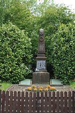
The war memorial

Border stone between the Duchy of Nassau and the Kingdom of Prussia near Rodenroth


Individual evidence
- ↑ a b c data and facts. In: website. Greifenstein community, archived from the original ; accessed in February 2019 .
- ^ Federal Statistical Office (ed.): Historical municipality directory for the Federal Republic of Germany. Name, border and key number changes in municipalities, counties and administrative districts from May 27, 1970 to December 31, 1982 . W. Kohlhammer, Stuttgart / Mainz 1983, ISBN 3-17-003263-1 , p. 356 .
- ↑ Law on the restructuring of the Dill district, the districts of Gießen and Wetzlar and the city of Gießen (GVBl. II 330–28) of May 13, 1974 . In: The Hessian Minister of the Interior (ed.): Law and Ordinance Gazette for the State of Hesse . 1974 No. 17 , p. 237 ff ., § 19 ( online at the information system of the Hessian state parliament [PDF; 1,2 MB ]).
- ↑ Gerstenmeier, K.-H. (1977): Hessen. Municipalities and counties after the regional reform. A documentation. Melsungen. P. 293. DNB 770396321
- ↑ Main statute of the community of Greifenstein § 6. Accessed in February 2019.
- ↑ a b c Rodenroth, Lahn-Dill district. Historical local dictionary for Hessen. (As of October 16, 2018). In: Landesgeschichtliches Informationssystem Hessen (LAGIS).
- ^ Michael Rademacher: German administrative history from the unification of the empire in 1871 to the reunification in 1990. State of Hesse. (Online material for the dissertation, Osnabrück 2006).
- ↑ Local advisory boards of the community of Greifenstein , accessed in March 2017.
- ^ Website of the CVJM leisure center in Rodenroth
Web links
- Rodenroth district on the website of the municipality of Greifenstein.
- Rodenroth, Lahn-Dill district. Historical local dictionary for Hessen. In: Landesgeschichtliches Informationssystem Hessen (LAGIS).
- Literature on Rodenroth in the Hessian Bibliography