
Nenderoth
|
Nenderoth
Community Greifenstein
Coordinates: 50 ° 34 ′ 55 ″ N , 8 ° 11 ′ 54 ″ E
|
|
|---|---|
| Height : | 342 m above sea level NHN |
| Area : | 6.02 km² |
| Residents : | 425 (December 31, 2017) |
| Population density : | 71 inhabitants / km² |
| Incorporation : | January 1, 1977 |
| Postal code : | 35753 |
| Area code : | 06477 |
Nenderoth is a district of the municipality of Greifenstein in the Lahn-Dill district in Central Hesse .
geography
location
The village is located on the upper reaches of the Kallenbach between the mountains Knie (605 m) and Kahlenberg (405 m) in the Westerwald .
The district covers an area of 605 ha and is traversed by two bodies of water, the Kallenbach and the Leyenbach. About half is covered with forest. The rest is divided into agricultural areas (250 ha), courtyard and building areas, roads and paths.
climate
Topologically, Nenderoth still belongs to the Westerwald, but climatically it differs significantly from it due to the south-facing slope and the opening to the Lahn valley . This is also reflected in the vegetation . Because of this special climate, Nenderoth is also called the Nice of the Westerwald . It used to be said that it was always a “rock warmer” in Nenderoth than in the neighboring villages of Arborn and Odersberg .
history
The place name is derived from Nantherisrode , which means "clearing a Nandhari". The place was first mentioned in a document in 993. In the Middle Ages, Nenderoth became the center of the " Kalenberger Zent " and in 1310 received its own jurisdiction from the Lords of Merenberg . A hall that was attached to the church served as a place of justice.
Due to the effects of the war and political changes, Nenderoth gradually lost its importance. The residents found the only way to earn a living in agriculture. But here, too, a change has occurred. In the 1970s, tourism developed as an industry for a short time. During this time, Nenderoth took part repeatedly in the competition “ Our village should be more beautiful ” and received several awards at state and federal level. Today the place has essentially become a pure " residential community ". Until the late 1980s, the place had about 420 to 430 inhabitants. Due to the influx of resettlers and repatriates or asylum seekers, the number of residents has meanwhile increased to approx. 550 people. There are currently 425 residents.
Territorial reform
Nenderoth was the southernmost municipality in the old Dill district and was independent until the end of 1976. On January 1, 1977, in the course of the regional reform in Hesse , the municipality with the previously independent municipalities of Greifenstein, Arborn , Beilstein , Odersberg and Ulmtal became a new large municipality through the law on the reorganization of the Dill district, the districts of Gießen and Wetzlar and the city of Gießen Greifenstein merged . For Nenderoth, as for all formerly independent communities, a local district was formed with a local advisory board and local councilor . The local part of Beilstein became the seat of the municipal administration.
Territorial history and administration
The following list gives an overview of the territories in which Nenderoth was located and the administrative units to which it was subordinate:
- from 1255: Holy Roman Empire, Nassau-Dillenburg , Kalenberger Zent
- 1343–1561: Holy Roman Empire, Nassau-Beilstein , Beilstein Office
- 1562–1606: Holy Roman Empire, Nassau-Dillenburg, Amt Beilstein
- 1607–1620: Holy Roman Empire, Nassau-Beilstein, Beilstein Office
- from 1621 Holy Roman Empire, County / Principality of Nassau-Diez , Beilstein Office
- from 1790: Holy Roman Empire, Principality of Nassau-Diez, Mengerskirchen Office
- 1806–1813: Grand Duchy of Berg , Department of Sieg , Canton of Driedorf
- 1813–1815: Principality of Nassau-Orange , Mengerskirchen Office
- from 1816: German Confederation , Duchy of Nassau , Herborn office
- from 1849: German Confederation, Duchy of Nassau, Herborn district office
- from 1854: German Confederation, Duchy of Nassau, Herborn Office
- from 1867: North German Confederation , Kingdom of Prussia , Province of Hessen-Nassau , Administrative Region of Wiesbaden , Dillkreis
- from 1871: German Empire , Kingdom of Prussia, Province of Hessen-Nassau, administrative district of Wiesbaden, Dillkreis
- from 1918: German Empire, Free State of Prussia , Province of Hessen-Nassau, Administrative Region of Wiesbaden, Dillkreis
- from 1932: German Empire, Free State of Prussia, Province of Hesse-Nassau, District of Wiesbaden, District of Dillenburg
- from 1933: German Reich, Free State of Prussia, Province of Hessen-Nassau, Administrative Region of Wiesbaden, Dillkreis
- from 1944: German Empire, Free State of Prussia, Nassau Province , Dill District
- from 1945: American occupation zone , Greater Hesse , Wiesbaden district, Dillkreis
- from 1949: Federal Republic of Germany , State of Hesse , Wiesbaden district, Dillkreis
- from 1968: Federal Republic of Germany, State of Hesse, administrative district Darmstadt , Dillkreis
- from 1977: Federal Republic of Germany, State of Hesse, Darmstadt administrative district, Lahn-Dill district
- On January 1, 1977 the communities Ulmtal (with their districts) and Beilstein (with the districts Beilstein, Rodenroth and Rodenberg) merged with the places Arborn, Greifenstein, Nenderoth and Odersberg to form the new community Greifenstein. The municipal administration is based in Beilstein.
- from 1981: Federal Republic of Germany, State of Hesse, Gießen administrative district , Lahn-Dill district
population
Population development
| Nenderoth: Population from 1834 to 2017 | ||||
|---|---|---|---|---|
| year | Residents | |||
| 1834 | 284 | |||
| 1840 | 290 | |||
| 1846 | 306 | |||
| 1852 | 318 | |||
| 1858 | 343 | |||
| 1864 | 362 | |||
| 1871 | 362 | |||
| 1875 | 374 | |||
| 1885 | 392 | |||
| 1895 | 365 | |||
| 1905 | 340 | |||
| 1910 | 337 | |||
| 1925 | 341 | |||
| 1939 | 342 | |||
| 1946 | 480 | |||
| 1950 | 450 | |||
| 1956 | 376 | |||
| 1961 | 385 | |||
| 1967 | 410 | |||
| 1970 | 409 | |||
| 2011 | 380 | |||
| 2015 | 466 | |||
| 2017 | 425 | |||
| Data source: Historical municipality register for Hesse: The population of the municipalities from 1834 to 1967. Wiesbaden: Hessisches Statistisches Landesamt, 1968. Other sources: | ||||
Religious affiliation
Source: Historical local dictionary
| 1885: | 390 Protestant (= 99.49%), 2 Catholic (= 0.51%) residents |
| 1961: | 367 Protestant (= 95.32%), 16 Catholic (= 4.16%) residents |
Local advisory board
For the district of Nenderoth there is a five-person local advisory board with a local councilor . After the local elections in Hesse in 2016 , the mayor is Thomas Klein.
Attractions
In the center of the village is the old church from the 13th century, which was built as a fortified church. In the immediate vicinity is the old bakery with the local history museum. The bakery is still functional and is used by the “Nenderother Heimatstube” association several times a year. As a special scenic attraction you will find next to the node as the highest mountain of the southern Westerwald in the immediate vicinity a charming waterfall of the Leyenbach, as well as the “Sauerborn” on the left bank of the Kallenbach. From there in the direction of Johannisburg there was a 1000-year-old oak until summer 2012.

Nenderother Church
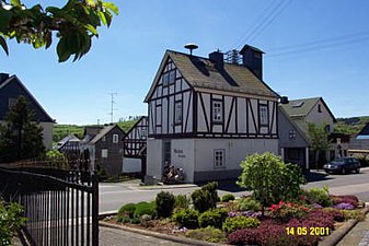
Nenderother bakery with local museum
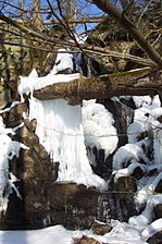
Waterfall in Nenderoth

1000 year old oak


Web links
- District Nenderoth on the website of the municipality of Greifenstein.
- Nenderoth, Lahn-Dill district. Historical local dictionary for Hessen. In: Landesgeschichtliches Informationssystem Hessen (LAGIS).
- Literature on Nenderoth in the Hessian Bibliography
Individual evidence
- ↑ a b c data and facts. In: website. Greifenstein community, archived from the original ; accessed in February 2019 .
- ↑ Law on the restructuring of the Dill district, the districts of Gießen and Wetzlar and the city of Gießen (GVBl. II 330–28) of May 13, 1974 . In: The Hessian Minister of the Interior (ed.): Law and Ordinance Gazette for the State of Hesse . 1974 No. 17 , p. 237 ff ., § 19 ( online at the information system of the Hessian state parliament [PDF; 1,2 MB ]).
- ↑ Main statute of the community of Greifenstein § 6. Accessed in February 2019.
- ↑ a b c Nenderoth, Lahn-Dill district. Historical local dictionary for Hessen. (As of October 16, 2018). In: Landesgeschichtliches Informationssystem Hessen (LAGIS).
- ^ Michael Rademacher: German administrative history from the unification of the empire in 1871 to the reunification in 1990. State of Hesse. (Online material for the dissertation, Osnabrück 2006).
- ↑ Wilhelm von der Nahmer: Handbuch des Rheinischen Particular-Rechts: Development of the territorial and constitutional relations of the German states on both banks of the Rhine: from the first beginning of the French Revolution up to the most recent times . tape 3 . Sauerländer, Frankfurt am Main 1832, OCLC 165696316 , p. 101 f . ( Online at google books ).
- ↑ Local advisory boards of the community of Greifenstein , accessed in March 2017.