
Arborn
|
Arborn
Community Greifenstein
Coordinates: 50 ° 35 ′ 6 ″ N , 8 ° 10 ′ 24 ″ E
|
|
|---|---|
| Height : | 411 m above sea level NHN |
| Area : | 5.46 km² |
| Residents : | 599 (December 31, 2017) |
| Population density : | 110 inhabitants / km² |
| Incorporation : | January 1, 1977 |
| Postal code : | 35753 |
| Area code : | 06477 |
 View of Arborn
|
|
Arborn has been part of the municipality of Greifenstein in the Lahn-Dill district in Central Hesse since 1977 .
geography
The junction is in the district , at 605 m above sea level. NHN one of the highest mountains in the Hessian part of the Westerwald .
history
Arborn lies on the southern slope of the Westerwald . The first documentary mention took place in the year 1391. On June 17th of that year Bishop Eckard von Worms enfeoffed the knight Conrad von Essershausen with the castle Essershausen, as well as tithe and other basic rights Weilmünster , Mengerskirchen and Arborn. We get to know the landlords under whom Arborn was not founded, but was renamed. They are the bishops of Worms . The Nassau counts acquired the Worms property in the Calenberger Zent , to which Arborn also belonged, and as a result had become the legal successors of the bishops. In addition, sales and pledges show that the Beilstein Counts took almost all of the Arborner Dorfmark as property.
Territorial reform
On January 1, 1977, the community was Arborn in the course of administrative reform in Hesse with the hitherto also independent communities Greifenstein Beilstein , Nenderoth , Oderberg and Ulmtal powerful state law to the new greater community Greifenstein together . For Arborn, as for all formerly independent municipalities, a local district with a local advisory board and local council was formed. The local part of Beilstein became the seat of the municipal administration.
Territorial history and administration
The following list gives an overview of the territories in which Arborn was located or the administrative units to which it was subordinate:
- 14th century: Holy Roman Empire, Nassau-Dillenburg , Kalenberger Zent
- 1343–1561: Holy Roman Empire, Nassau-Beilstein , Beilstein Office
- 1562–1606: Holy Roman Empire, Nassau-Dillenburg, Amt Beilstein
- 1607–1620: Holy Roman Empire, Nassau-Beilstein, Beilstein Office
- from 1621 Holy Roman Empire, County / Principality of Nassau-Diez , Beilstein Office
- from 1790: Holy Roman Empire, Principality of Nassau-Diez, Mengerskirchen Office
- 1806–1813: Grand Duchy of Berg , Department of Sieg , Canton of Driedorf
- 1813–1815: Principality of Nassau-Orange , Mengerskirchen Office
- from 1816: German Confederation , Duchy of Nassau , Herborn office
- from 1849: German Confederation, Duchy of Nassau, Herborn district office
- from 1854: German Confederation, Duchy of Nassau, Herborn Office
- from 1867: North German Confederation , Kingdom of Prussia , Province of Hessen-Nassau , Administrative Region of Wiesbaden , Dillkreis
- from 1871: German Empire , Kingdom of Prussia, Province of Hessen-Nassau, administrative district of Wiesbaden, Dillkreis
- from 1918: German Empire, Free State of Prussia , Province of Hessen-Nassau, Administrative Region of Wiesbaden, Dillkreis
- from 1932: German Empire, Free State of Prussia, Province of Hesse-Nassau, District of Wiesbaden, District of Dillenburg
- from 1933: German Reich, Free State of Prussia, Province of Hessen-Nassau, Administrative Region of Wiesbaden, Dillkreis
- from 1944: German Empire, Free State of Prussia, Nassau Province , Dill District
- from 1945: American occupation zone , Greater Hesse , Wiesbaden district, Dillkreis
- from 1949: Federal Republic of Germany , State of Hesse , Wiesbaden district, Dillkreis
- from 1968: Federal Republic of Germany, State of Hesse, administrative district Darmstadt , Dillkreis
- from 1977: Federal Republic of Germany, State of Hesse, Darmstadt administrative district, Lahn-Dill district
- On January 1, 1977 the communities Ulmtal (with their districts) and Beilstein (with the districts Beilstein, Rodenroth and Rodenberg) merged with the places Arborn, Greifenstein, Nenderoth and Odersberg to form the new community Greifenstein. The municipal administration is based in Beilstein.
- from 1981: Federal Republic of Germany, State of Hesse, Gießen administrative district , Lahn-Dill district
population
Population development
| Arborn: Population from 1834 to 2017 | ||||
|---|---|---|---|---|
| year | Residents | |||
| 1834 | 411 | |||
| 1840 | 411 | |||
| 1846 | 447 | |||
| 1852 | 450 | |||
| 1858 | 452 | |||
| 1864 | 480 | |||
| 1871 | 410 | |||
| 1875 | 419 | |||
| 1885 | 435 | |||
| 1895 | 452 | |||
| 1905 | 452 | |||
| 1910 | 422 | |||
| 1925 | 464 | |||
| 1939 | 428 | |||
| 1946 | 577 | |||
| 1950 | 530 | |||
| 1956 | 475 | |||
| 1961 | 469 | |||
| 1967 | 493 | |||
| 1970 | 500 | |||
| 2011 | 577 | |||
| 2014 | 596 | |||
| 2017 | 599 | |||
| Data source: Historical municipality register for Hesse: The population of the municipalities from 1834 to 1967. Wiesbaden: Hessisches Statistisches Landesamt, 1968. Other sources: | ||||
Religious affiliation
Source: Historical local dictionary
| 1885: | 434 Protestant (= 99.77%), one Catholic (= 0.23%) residents |
| 1961: | 429 Protestant (= 91.47%), 35 Catholic (= 7.46%) residents |
Local advisory board
For the district of Arborn there is a five-person local advisory board with a local councilor. After the local elections in Hesse in 2016 , the mayor is Uwe Schnitter.
Culture and sights
Buildings
Arborn has a town center made up of several half-timbered houses, some of which date from the 17th century. This town center is characterized by the historic schoolhouse, a chapel school with a roof turret built in 1717 , which was expanded into a museum by the local heritage association . There was a prayer room on the upper floor of the school building. Together with the Backes from 1800, the school building delimits a small square.

Backes in Arborn
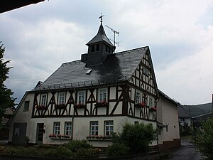
Old school building in the town center


Regular events
Every year in Arborn, the young people who celebrate their 13th birthday this year put up the Pentecost tree, a custom that only exists in this form in this place in the Westerwald.
Individual evidence
- ↑ a b c data and facts. In: website. Greifenstein community, archived from the original ; accessed in February 2019 .
- ↑ Map services of the Federal Agency for Nature Conservation ( information )
- ↑ Law on the restructuring of the Dill district, the districts of Gießen and Wetzlar and the city of Gießen (GVBl. II 330–28) of May 13, 1974 . In: The Hessian Minister of the Interior (ed.): Law and Ordinance Gazette for the State of Hesse . 1974 No. 17 , p. 237 ff ., § 19 ( online at the information system of the Hessian state parliament [PDF; 1,2 MB ]).
- ↑ Main statute of the community of Greifenstein § 6. Accessed in February 2019.
- ↑ a b c Arborn, Lahn-Dill district. Historical local dictionary for Hessen. (As of October 16, 2018). In: Landesgeschichtliches Informationssystem Hessen (LAGIS).
- ^ Michael Rademacher: German administrative history from the unification of the empire in 1871 to the reunification in 1990. State of Hesse. (Online material for the dissertation, Osnabrück 2006).
- ↑ Local advisory boards of the Greifenstein community , accessed in February 2017.
Web links
- District Arborn on the website of the municipality of Greifenstein.
- Arborn, Lahn-Dill district. Historical local dictionary for Hessen. In: Landesgeschichtliches Informationssystem Hessen (LAGIS).
- Literature about Arborn in the Hessian Bibliography
- Website for the location of the "Heimatverein 1952 dv Arborn"