
Breitscheid (Hesse)
| coat of arms | Germany map | |
|---|---|---|
.png)
|
Coordinates: 50 ° 41 ′ N , 8 ° 12 ′ E |
|
| Basic data | ||
| State : | Hesse | |
| Administrative region : | to water | |
| County : | Lahn-Dill district | |
| Height : | 462 m above sea level NHN | |
| Area : | 31.75 km 2 | |
| Residents: | 4684 (Dec. 31, 2019) | |
| Population density : | 148 inhabitants per km 2 | |
| Postal code : | 35767 | |
| Area code : | 02777 | |
| License plate : | LDK, DIL | |
| Community key : | 06 5 32 004 | |
| LOCODE : | DE BTE | |
| Address of the municipal administration: |
Rathausstrasse 14 35767 Breitscheid |
|
| Website : | ||
| Mayor : | Roland Lay ( independent ) | |
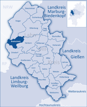
| Location of the community Breitscheid in the Lahn-Dill district | ||
  |
||

Breitscheid is a municipality in the Lahn-Dill district in central Hesse .
geography


location
Breitscheid lies at an altitude of 266 to 614 meters on the eastern slope of the Westerwald at the border triangle of Hesse - Rhineland-Palatinate - North Rhine-Westphalia .
Neighboring communities
Breitscheid borders in the north on the municipality of Burbach ( district Siegen-Wittgenstein in North Rhine-Westphalia ), the cities Haiger and Dillenburg , in the east on the city of Herborn , in the south on the municipality Driedorf (all in the Lahn-Dill district) and in the west to the communities of Willingen and Liebenscheid (both in the Westerwaldkreis in Rhineland-Palatinate ).
Community structure
In addition to the main town Breitscheid, the community consists of the districts Medenbach , Erdbach , Gusternhain and Rabenscheid .
history
The oldest surviving mention of Breitscheid, as "Bedinscheit", comes from 1230. The tower of the church built in 1309 has been preserved to this day. Likewise, the first bell from 1450 is still in place and is rung regularly together with the second bell from 1519. In 1536, when the chaplain Jakob Ebersbach was appointed, the Reformation was introduced in Breitscheid.
The predominantly agricultural town made use of its rich clay deposits from the 18th century, and so from 1711 onwards numerous harvester shops were established . A brickwork was first mentioned in a document as early as 1706 and a pipe bakery in 1710. Lignite mining began in 1748, the "Ludwigs Zuversicht" lignite mine was opened in 1832 west of the village. In 1880 Breitscheid had 650 inhabitants, about a quarter of whom lived from the pottery trade. With the construction of the chamotte factory in 1899, a new era dawned in Breitscheid: Many formerly independent Häfner gave up their craft and became wage workers in the "factory". In 1916 there were 948 inhabitants in Breitscheid and 1091 in 1925.
At the end of the 1930s, the Wehrmacht built a field airfield above the village. In 1939 Breitscheid finally got the long-awaited rail connection after construction work on the Haiger - Breitscheid railway line had been suspended in 1914 due to the outbreak of the First World War. On March 11, 1945, American Marauder planes dropped 259 bombs over the airfield, but did not hit it, but landed over the eastern edge of Breitscheid and destroyed numerous houses. Another carpet of bombs hit the village of Gusternhain 11 minutes later and caused great damage there.
In 1956, a meteorite weighing around 1.5 kilograms fell near Breitscheid and belongs to the H5 class of chondrites . The largest part is now in the Max Planck Institute for Chemistry in Mainz .
Incorporations
As part of the regional reform in Hesse , the municipality of Rabenscheid voluntarily joined the municipality of Breitscheid on December 31, 1971,
On January 1, 1977, Erdbach, Gusternhain and Medenbach were incorporated into the district by the law to reorganize the Dill district, the districts of Gießen and Wetzlar and the city of Gießen . Local districts with local advisory councils and local councilors were formed for all formerly independent communities .
The core community Breitscheid is the geographical, economic, cultural and administrative center of the community as a whole. With a population of around 2,000 today, the old church village is not only the largest district, but also represents an important traffic junction in the Westerwald with its star-shaped streets diverging in all directions.
Territorial history and administration
The following list gives an overview of the territories in which Breitscheid was located and the administrative units to which it was subordinate:
- before 1739: Holy Roman Empire , County / Principality of Nassau-Dillenburg , Herborn office
- from 1739: Holy Roman Empire, Principality of Nassau-Diez , Herborn Office
- 1806–1813: Grand Duchy of Berg , Department of Sieg , Canton of Herborn
- 1813–1815: Principality of Nassau-Orange , Herborn office
- from 1816: German Confederation , Duchy of Nassau , Herborn office
- from 1849: German Confederation, Duchy of Nassau, Herborn district office
- from 1854: German Confederation, Duchy of Nassau, Herborn Office
- from 1867: North German Confederation , Kingdom of Prussia , Province of Hessen-Nassau , Administrative Region of Wiesbaden , Dillkreis
- from 1871: German Empire , Kingdom of Prussia, Province of Hessen-Nassau, administrative district of Wiesbaden, Dillkreis
- from 1918: German Empire, Free State of Prussia , Province of Hessen-Nassau, Administrative Region of Wiesbaden, Dillkreis
- from 1932: German Empire, Free State of Prussia, Province of Hesse-Nassau, District of Wiesbaden, District of Dillenburg
- from 1933: German Reich, Free State of Prussia, Province of Hessen-Nassau, Administrative Region of Wiesbaden, Dillkreis
- from 1944: German Empire, Free State of Prussia, Nassau Province , Dill District
- from 1945: American occupation zone , Greater Hesse , Wiesbaden district, Dillkreis
- from 1949: Federal Republic of Germany , State of Hesse , Wiesbaden district, Dillkreis
- from 1968: Federal Republic of Germany, State of Hesse, administrative district Darmstadt , Dillkreis
- from 1977: Federal Republic of Germany, State of Hesse, Darmstadt administrative district, Lahn-Dill district
- from 1981: Federal Republic of Germany, State of Hesse, Gießen administrative district , Lahn-Dill district
population
Population development
| Breitscheid: Population from 1834 to 2015 | ||||
|---|---|---|---|---|
| year | Residents | |||
| 1834 | 521 | |||
| 1840 | 580 | |||
| 1846 | 598 | |||
| 1852 | 622 | |||
| 1858 | 620 | |||
| 1864 | 657 | |||
| 1871 | 674 | |||
| 1875 | 670 | |||
| 1885 | 741 | |||
| 1895 | 770 | |||
| 1905 | 872 | |||
| 1910 | 948 | |||
| 1925 | 1,091 | |||
| 1939 | 1,134 | |||
| 1946 | 1,550 | |||
| 1950 | 1,688 | |||
| 1956 | 1,631 | |||
| 1961 | 1,677 | |||
| 1967 | 1,671 | |||
| 1970 | 1,735 | |||
| 1972 | 2,077 | |||
| 1976 | 4,326 | |||
| 1984 | 4,447 | |||
| 1992 | 4,753 | |||
| 2000 | 5,000 | |||
| 2004 | 5,081 | |||
| 2010 | 5.110 | |||
| 2015 | 4,800 | |||
| Data source: Historical municipality register for Hesse: The population of the municipalities from 1834 to 1967. Wiesbaden: Hessisches Statistisches Landesamt, 1968. Further sources:; 1972 :; 1976 :; 1984 :; 1992 :; 2000, 2015 :; 2004 :; after 2000: Breitscheid municipality figures - data - facts (several values from the web archive) From 1972 including the places incorporated in the course of the regional reform in Hesse . | ||||
Religious affiliation
Source: Historical local dictionary ; 2011 census database
| • 1885: | 728 Protestants (= 98.25%), one Catholic 11 Christians of other denominations (= 1.48%), as well as one resident of another faith. |
| • 1961: | 1363 Protestant (= 81.28%), 289 Roman Catholic (= 17.23%) inhabitants |
| • 2011: | 2496 Protestant (= 50.6%), 434 (= 8.8%) Roman Catholic, 2006 (= 40.6%) other / no / no information residents |
politics
Community representation
The local elections on March 6, 2016 produced the following results, compared to previous local elections:
| Parties and constituencies | % 2016 |
Seats 2016 |
% 2011 |
Seats 2011 |
% 2006 |
Seats 2006 |
% 2001 |
Seats 2001 |
||
|---|---|---|---|---|---|---|---|---|---|---|
| CDU | Christian Democratic Union of Germany | 46.9 | 10 | 42.1 | 10 | 39.2 | 9 | 33.9 | 8th | |
| FWG | Free community of voters | 38.1 | 9 | 34.0 | 8th | 39.3 | 9 | 39.9 | 9 | |
| SPD | Social Democratic Party of Germany | 18.3 | 4th | 23.9 | 5 | 21.6 | 5 | 26.2 | 6th | |
| total | 100.0 | 23 | 100.0 | 23 | 100.0 | 23 | 100.0 | 23 | ||
| Voter turnout in% | 46.9 | 42.0 | 40.2 | 44.8 | ||||||
coat of arms
The coat of arms was approved on February 26, 1988 by the Hessian Ministry of the Interior.
Blazon : "Above a shortened and curved golden tip, this covered with a red-tongued blue lion head and five blue shingles, in the blue field in front a golden pot, at the back a golden mallet and a golden hammer crossed diagonally."
Culture and sights
Museums
- The Breitscheid Pottery Museum shows the development of the pottery trade and shows pottery products from 250 years.
- The "Zeitsprge" museum in the Erdbach district - geology, archeology, cave research and railway history
Attractions
Part of the autumn labyrinth stalactite cave was expanded into a show cave and opened in 2009. In the Breitscheid-Erdbach karst area there is also a karst spring , several sinkholes and the Erdbach caves, which can also be reached via a special karst educational trail.
Sports and leisure opportunities
There are many sports clubs in the Breitscheid community where you can play football , tennis , table tennis or sports shooting , for example . There is a sports hall in the core community and sports fields in all parts of the village. In summer you can practice gliding , powered flying and parachuting at the Breitscheid airfield , as well as cross-country skiing in winter .
Barbecue areas and leisure facilities are available in the districts. The two long-distance hiking trails Westerwaldsteig and Rothaarsteig run through the municipality.
Economy and Infrastructure
In the core community there is a multi-purpose hall and the other districts also have village community houses. There is an unheated outdoor pool in Medenbach.
In 2019, the construction of a health center began, in which a medical practice community, the community care station Breitscheid with a day care and other facilities for health will be housed. The opening is planned for September 2020.
traffic
The federal highway 255 touches the southern municipality area. Furthermore, the running state roads 3042, 3044 and 3391 as well as many local roads through the community. The Herborn-West motorway junction on federal motorway 45 is about seven kilometers away from the core community.
The airfield Breitscheid is also known locally by its bi-annual United flight days.
Breitscheid used to be connected to the rail network via the Haiger – Breitscheid railway line. In the Erdbach district there was a switchback station that belonged to the Westerwaldquerbahn .
education
The Fritz Philippi School is located in Breitscheid and consists of a primary , secondary and secondary school with a special level . There is also a primary school in the Medenbach district. Secondary schools ( grammar school ) can be attended in Herborn or Dillenburg.
There are kindergartens in Breitscheid, Medenbach and Rabenscheid.
Resident companies
The most important employers in the municipality are the companies Westerwälder Thonindustrie , Georg GmbH, Cartonia Wellpappen, Sahm Holzbau, Schreiner Formen and Hofmann Ceramik.
Personalities
Sons and daughters of the church
- Wilhelm Kegel (1890–1971), geologist
- Marita Metz-Becker (* 1953), university professor at the Institute for European Ethnology / Cultural Studies
Connected to the community
- The pastor and writer Fritz Philippi (1869–1933) worked in Breitscheid from 1894 to 1904.
- The hammer thrower Kathrin Klaas (* 1984) grew up in Breitscheid.
Individual evidence
- ↑ Hessian State Statistical Office: Population status on December 31, 2019 (districts and urban districts as well as municipalities, population figures based on the 2011 census) ( help ).
- ↑ Historical Alt-Breitscheid. Accessed February 1, 2020 .
- ↑ Hans Becker: Breitscheid, Meine Heimat , Verlag Books on Demand, 2005, ISBN 3-8334-3718-9 , p. 13
- ^ District savings bank Dillenburg: Time - money - the economy , 1995, p. 103
- ↑ Historical Alt-Breitscheid. Accessed February 1, 2020 .
- ^ Bombing 1945 Alt-Breitscheid. Accessed February 1, 2020 .
- ↑ Breitscheid. Meteoritical Bulletin, accessed June 5, 2020 .
- ^ Federal Statistical Office (ed.): Historical municipality directory for the Federal Republic of Germany. Name, border and key number changes in municipalities, counties and administrative districts from May 27, 1970 to December 31, 1982 . W. Kohlhammer, Stuttgart / Mainz 1983, ISBN 3-17-003263-1 , p. 356 .
- ↑ Law on the restructuring of the Dill district, the districts of Gießen and Wetzlar and the city of Gießen (GVBl. II 330–28) of May 13, 1974 . In: The Hessian Minister of the Interior (ed.): Law and Ordinance Gazette for the State of Hesse . 1974 No. 17 , p. 237 ff ., § 23 ( online at the information system of the Hessian state parliament [PDF; 1,2 MB ]).
- ↑ K.-H. Gerstenmeier: Hessen. Municipalities and counties after the regional reform. A documentation. Melsungen 1977, p. 285. DNB 770396321
- ↑ Main statute § 6. (PDF; 44 kB) In: Website. Breitscheid municipality, accessed February 2019 .
- ↑ a b c Breitscheid, Lahn-Dill district. Historical local dictionary for Hessen. (As of May 24, 2018). In: Landesgeschichtliches Informationssystem Hessen (LAGIS).
- ^ Michael Rademacher: German administrative history from the unification of the empire in 1871 to the reunification in 1990. State of Hesse. (Online material for the dissertation, Osnabrück 2006).
- ^ Local elections 1972; Relevant population of the municipalities on August 4, 1972 . In: The Hessian Minister of the Interior (ed.): State Gazette for the State of Hesse. 1972 No. 33 , p. 1424 , point 1025 ( online at the information system of the Hessian state parliament [PDF; 5.9 MB ]).
- ↑ Local elections 1977; Relevant population figures for the municipalities as of December 15, 1976 . In: The Hessian Minister of the Interior (ed.): State Gazette for the State of Hesse. 1976 No. 52 , p. 2283 , point 1668 ( online at the information system of the Hessian state parliament [PDF; 10.3 MB ]).
- ^ Local elections 1985; Relevant population of the municipalities as of October 30, 1984 . In: The Hessian Minister of the Interior (ed.): State Gazette for the State of Hesse. 1984 No. 46 , p. 2175 , point 1104 ( online at the information system of the Hessian state parliament [PDF; 5.5 MB ]).
- ↑ local elections 1993; Relevant population of the municipalities as of October 21, 1992 . In: The Hessian Minister of the Interior (ed.): State Gazette for the State of Hesse. 1992 No. 44 , p. 2766 , point 935 ( online at the information system of the Hessian state parliament [PDF; 6.1 MB ]).
- ↑ Municipal data sheet : Breitscheid. (PDF; 222 kB) In: Hessisches Gemeindelexikon. HA Hessen Agency GmbH
- ↑ Hessian municipal statistics, Edition 2 2005. Hessian State Statistical Office
- ^ Census database - results of the 2011 census. Retrieved on February 1, 2020 .
- ^ Result of the municipal election on March 6, 2016. Hessian State Statistical Office, accessed in April 2016 .
- ^ Hessian State Statistical Office: Result of the municipal elections on March 27, 2011
- ^ Hessian State Statistical Office: Result of the municipal elections on March 26, 2006
- ^ Approval of a coat of arms and a flag of the Breitscheid community, Lahn-Dill-Kreis dated February 26, 1988 . In: The Hessian Minister of the Interior (ed.): State Gazette for the State of Hesse. 1988 No. 11 , p. 622 , item 279 ( online at the information system of the Hessian state parliament [PDF; 6.3 MB ]).
- ^ Breitscheid Health Center. Accessed February 1, 2020 (German).
Web links
- Website of the Breitscheid community
- Breitscheid, Lahn-Dill district. Historical local dictionary for Hessen. In: Landesgeschichtliches Informationssystem Hessen (LAGIS).
- Information on the community of Breitscheid. In: Hessisches Gemeindelexikon. HA Hessen Agentur GmbH , 2016.
- Literature on Breitscheid in the Hessian Bibliography
- Link catalog on Breitscheid at curlie.org (formerly DMOZ )

Asslar | Bischoffen | Braunfels | Breitscheid | Dietzhölztal | Dillenburg | Driedorf | Ehringshausen | Eschenburg | Greifenstein | Haiger | Herborn | Hohenahr | Hüttenberg | Lahnau | Leun | Mittenaar | Schöffengrund | Siegbach | Sense | Solms | Waldsolms | Wetzlar