Kundert
| coat of arms | Germany map | |
|---|---|---|

|
Coordinates: 50 ° 43 ' N , 7 ° 48' E |
|
| Basic data | ||
| State : | Rhineland-Palatinate | |
| County : | Westerwaldkreis | |
| Association municipality : | Hachenburg | |
| Height : | 300 m above sea level NHN | |
| Area : | 3.14 km 2 | |
| Residents: | 253 (Dec. 31, 2019) | |
| Population density : | 81 inhabitants per km 2 | |
| Postal code : | 57629 | |
| Area code : | 02662 | |
| License plate : | WW | |
| Community key : | 07 1 43 252 | |
| Association administration address: | Gartenstrasse 11 57627 Hachenburg |
|
| Website : | ||
| Local Mayor : | Burkhard Schneider | |
| Location of the local community Kundert in the Westerwaldkreis | ||
Kundert is a municipality in the Westerwaldkreis in Rhineland-Palatinate . It belongs to the Hachenburg community .
Geographical location
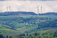
The community is located in the Westerwald between Limburg an der Lahn and Siegen , in the nature and landscape protection area of Kroppacher Switzerland . To the north of the village lies the border with the district of Altenkirchen (Westerwald) , Malberg in the east, Limbach in the south, Heimborn in the south-west and Mörsbach in the north-west .
history
The place is first mentioned in 1346 with the name Kunderoed and only later the name Kundert is mentioned. In the Middle Ages, the village of Hetzenhausen was located on the north-eastern edge of the village and is now a desert . The location of the desert has been handed down in the field names "In der Hetten" (huts) and "Hette". North of the community there is a historical boundary stone with the designation SH (for the Sayn-Hachenburg ) and on the other side SA (for the Sayn - Old Churches ). It was built after 1671 as a border marker between these two domains. One kilometer to the northeast is the so-called "Schwedengraben" on the road to Steinebach. The origin of the Landwehr is unknown.
The village of Kundert belonged to the parish of Kroppach and until the middle of the 17th century it belonged to the county of Sayn . After the introduction of the Reformation in the county of Sayn, the inhabitants were first Lutheran and later reformed. After the division of the County of Sayn in the 17th century, Kundert was part of the County of Sayn-Hachenburg .
In 1799 the county was inherited by the princes of Nassau-Weilburg . In connection with the formation of the Rhine Confederation , the region and with it Kundert came to the newly established Duchy of Nassau in 1806 . Under the Nassau administration, Kundert was assigned to the Hachenburg office. After the annexation of the Duchy of Nassau, the place came to the Kingdom of Prussia in 1866 and from 1868 on belonged to the province of Hessen-Nassau and the Oberwesterwaldkreis . Kundert has been part of the state of Rhineland-Palatinate since 1946 .
The ore mining carried out in neighboring communities was also pursued in Kundert, but only with moderate success. The former Steinchen mine turned out to be unprofitable, despite repeated attempts, and as a result of this it was not expanded any further. Remains of the pit can still be found in the area of the "Scherbach".
Kundert used to be an agriculturally oriented village, today it is more of a residential community .
- Cultural monuments
→ see list of cultural monuments in Kundert
- Population development
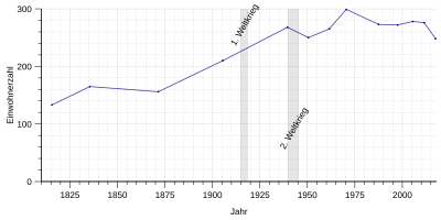
The development of the population of Kundert, the values from 1871 to 1987 are based on censuses:
|
|
politics
Municipal council
The local council in Kundert consists of six council members, who were elected by a majority vote in the local elections on May 26, 2019 , and the honorary local mayor as chairman.
mayor
Local mayor Burkhard Schneider was confirmed in his office for a further five years in the direct election on May 26, 2019 with 90.40% of the vote.
coat of arms
| Blazon : “By a silver-blue wavy bar divided by blue and silver. Above left and right two silver ears of wheat crossed diagonally, below a blue hammer and a blue clearing hoe crossed diagonally. " | |
State elections
Kundert is an SPD stronghold. Hendrik Hering received almost 80 percent of the first votes in the state elections in Kundert in March 2016.
Economy and Infrastructure
traffic
The B 414 runs south of the village and leads from Hohenroth to Hachenburg . The next motorway junctions are in Freudenberg , Siegen , Wilnsdorf or Herborn on the A 45 Dortmund - Gießen . The closest ICE stop is Montabaur train station on the Cologne – Rhein / Main high-speed line .
Public facilities
The community has a public soccer field and playground , an extensive network of hiking trails , its own barbecue hut and two half-timbered houses belonging to the Unnau Children's Cancer Aid. There is also a community baking house in Kundert with a continuous baking tradition. There is also a mixed choir that makes a significant contribution to community life. Furthermore, there is a typical regional mining cooperative in Kundert , which can be traced back to the mining tradition of the surrounding area. Even today the Hauberg is managed independently by the members.
literature
- Hellmuth Gensicke : The parish of Kroppach. In: Nassauische Annalen 83. 1972, pp. 209-231.
- Markus Müller: From Contzenrode to Kundert 1346–1996. A journey through the 650-year history of a Westerwald community . Ed .: Local community Kundert. Kundert 1997.
- Dieter Trautmann: The field names of the Kundert district . In: From the country and people at the Nister . tape 32 (2009) , pp. 1-24 .
Web links
- Kundert. Verbandsgemeinde Hachenburg
- Jutta Kastenholz: Kundert - a portrait of the place. In: This country. SWR television, May 10, 2007, archived from the original on May 17, 2014 .
Individual evidence
- ↑ State Statistical Office of Rhineland-Palatinate - population status 2019, districts, communities, association communities ( help on this ).
- ^ Landscape Museum Westerwald Hachenburg (Ed.): Natural and cultural-historical monuments in the Westerwald: Kroppacher Switzerland and Hachenburg (= Westerwald contributions . Volume 1 ). Hachenburg 1981, p. 60 .
- ↑ Daniel Schneider: The development of denominations in the county of Sayn in plan . In: Heimat-Jahrbuch des Kreis Altenkirchen . tape 58 (2015) , pp. 74-80 .
- ↑ State Statistical Office Rhineland-Palatinate: Regional data.
- ^ The Regional Returning Officer Rhineland-Palatinate: Local elections 2019, city and municipal council elections.
- ^ The Regional Returning Officer for Rhineland-Palatinate: direct elections 2019. see Hachenburg, Verbandsgemeinde, 15th line of results. Retrieved June 7, 2020 .
- ↑ WW-Kurier: The Westerwaldkreis has voted. MVV Medienverlag Westerwald-Sieg UG & Co. KG, Wissen, May 25, 2014, accessed on June 7, 2020 .
- ^ Local community Kundert on the website of the Verbandsgemeinde Hachenburg
- ↑ Mona Jaeger: Where the trees grow into the sky. In a small town in Rhineland-Palatinate, the SPD has been achieving election results on a socialist scale for years. In: Frankfurter Allgemeine Zeitung of September 6, 2017, p. 3 ( online ).
- ^ The State Returning Officer Rhineland-Palatinate: State Election 2016, final result Kundert. ( Memento from March 28, 2016 in the Internet Archive )


