Kadenbach
| coat of arms | Germany map | |
|---|---|---|

|
Coordinates: 50 ° 23 ' N , 7 ° 44' E |
|
| Basic data | ||
| State : | Rhineland-Palatinate | |
| County : | Westerwaldkreis | |
| Association municipality : | Montabaur | |
| Height : | 250 m above sea level NHN | |
| Area : | 4.45 km 2 | |
| Residents: | 1327 (Dec. 31, 2019) | |
| Population density : | 298 inhabitants per km 2 | |
| Postal code : | 56337 | |
| Area code : | 02620 | |
| License plate : | WW | |
| Community key : | 07 1 43 039 | |
| Association administration address: | Konrad-Adenauer-Platz 8 56410 Montabaur |
|
| Website : | ||
| Mayoress : | Ute little kitchen | |
| Location of the local community Kadenbach in the Westerwaldkreis | ||
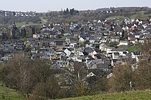
Kadenbach is a municipality in the Westerwaldkreis in Rhineland-Palatinate . It belongs to the Montabaur community . Until December 17, 1938, the official spelling of the community name was "Cadenbach".
geography
The community is located in the Augst in the Westerwald between Montabaur and Koblenz and in the Nassau Nature Park .
history
Kadenbach was first mentioned in a document as "Catenbach" on August 1, 1110, when Archbishop Bruno of Trier donated a house to the Florinsstift in Koblenz to build a hospital and furnished it with goods in Kadenbach. In 1216 Archbishop Theoderich II transferred the hospital and the associated goods to the Teutonic Order in Koblenz . The Teutonic Order had the manorial rule in Kadenbach until 1809. Until the end of the 18th century, Alflen belonged to the rulers of Kurtrier and was assigned to the Ehrenbreitstein office. Within the administrative district, Kadenbach belonged to the "court in the Augst " to which Arzbach , Eitelborn and Neuhäusel also belonged. The Trier fire book from 1563 lists 14 fireplaces (households) in Kadenbach ( Cadenbach ), in 1684 there were 21.
Through the Reichsdeputationshauptschluss Kadenbach came to the office of Ehrenbreitstein in 1803 to the Principality of Nassau-Weilburg and from 1806 to the Duchy of Nassau and in 1816 was assigned to the Office of Montabaur . In 1866 the transition to the Kingdom of Prussia followed . Under the Prussian administration, the community belonged to the Unterwesterwaldkreis in the province of Hessen-Nassau from 1867 . Kadenbach has belonged to the state of Rhineland-Palatinate since 1946 and to the newly formed Westerwaldkreis since 1974.
The first school building in Kadenbach was completed in 1836, and the new school building was completed in 1878. The previous school building then became the teacher's apartment. In 1936 the spelling "Kadenbach" became the official place name. Numerous new buildings were built in the 20th century, including the new sports field between 1946 and 1948, the cemetery in 1950 and the church in 1953. The expansion of the settlement began in 1959 with the first development on Freiherr-vom-Stein-Strasse. Further settlement areas were added on Römerstrasse (1969 and 1972) and Brunnenstrasse (1969), "Auf der Höh" (1980) and "Auf der Höh II" (2001).
In 1962 a well was drilled near the sports field. In 1978 the " cheek " was torn down . The primary school had to be closed in 1986. In contrast, a new kindergarten was completed in 1988 and enlarged in 1994. The cemetery hall and the parish hall were completed in 1989, the redesign of the village square was also carried out in 1994. In 1995 the community acquired its own coat of arms. In 1999 the “Binnbachtal” nature discovery trail was opened, and in 2000 the “Maria in der Augst” chapel was completed. In 2011/2012, the old barbecue hut from the 1970s was demolished and replaced by a Finnish log house with a covered terrace.
- Population development
The development of the population of Kadenbach, the values from 1871 to 1987 are based on censuses:
|
|
politics
Municipal council
The municipal council in Kadenbach consists of 16 council members, who were elected in a personalized proportional representation in the local elections on May 26, 2019 , and the honorary local mayor as chairman.
The distribution of seats in the municipal council:
| choice | SPD | CDU | FWG | total |
|---|---|---|---|---|
| 2019 | 2 | 3 | 11 | 16 seats |
| 2014 | 3 | 3 | 10 | 16 seats |
| 2009 | 3 | 3 | 10 | 16 seats |
| 2004 | 4th | 3 | 9 | 16 seats |
- FWG = Free Voting Group Kadenbach e. V.
Mayor of Kadenbach
| 1948–1959: | Josef Nut |
| 1959–1969: | Julius Stotz |
| 1969–1989: | Alois Karbach |
| 1989-1994: | Heinrich Dombo |
| 1994-1997: | Hermann Schaa |
| 1998-2013: | Helmut Marx |
| since November 2013: | Ute little kitchen |
In the direct election on May 26, 2019, Ute Kühchen was confirmed in her office for another five years with a share of the vote of 73.28%.
coat of arms
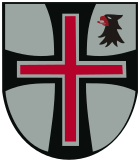
| Blazon : "A continuous black paw cross in silver, covered with a silver-lined red bar cross, in the left upper corner a torn, red-armored and red-tongued, black eagle's head ." | |
| Reasons for the coat of arms: In the Kadenbach coat of arms, the paw cross based on the black order cross and a black eagle head as part of the whole reminds of almost 600 years of membership in the Koblenz Teutonic Order . The red cross and the color silver symbolize the electoral sovereignty of the Electorate of Trier . |
Culture and sights
See the list of cultural monuments in Kadenbach
Economy and Infrastructure
In 2006 a new branch of Raiffeisenbank Unterwesterwald was built.
There is also a restaurant with a hall for club events and family celebrations.
traffic
The next motorway junction is Montabaur on the A3 Cologne - Frankfurt am Main , about twelve kilometers away.
Public facilities
There are three children's playgrounds and a ball playground for young people in the community.
There is a kindergarten built for three groups, which is run by the Kath. Parish of St. Josef is operated.
The primary school was closed in 1986. The old school building, like the former teachers' house, is owned by the community. Both are currently rented to companies.
Web links
- Internet presence of the local community Kadenbach
- Local community Kadenbach on the website of the Verbandsgemeinde Montabaur
Individual evidence
- ↑ State Statistical Office of Rhineland-Palatinate - population status 2019, districts, communities, association communities ( help on this ).
- ↑ Information sheet on the 900th anniversary of Kaddebach ( Memento from July 30, 2012 in the Internet Archive ) (PDF; 480 kB)
- ^ Wilhelm Fabricius : Explanations of the historical atlas of the Rhine province, Volume 2: The map of 1789. Bonn 1898, pp. 134, 153.
- ↑ State Statistical Office Rhineland-Palatinate - regional data
- ^ The Regional Returning Officer Rhineland-Palatinate: Local elections 2019, city and municipal council elections
- ^ The Regional Returning Officer Rhineland-Palatinate: direct elections 2019. see Montabaur, Verbandsgemeinde, 13th line of results. Retrieved June 21, 2020 .


