Rotenhain
| coat of arms | Germany map | |
|---|---|---|

|
Coordinates: 50 ° 36 ' N , 7 ° 53' E |
|
| Basic data | ||
| State : | Rhineland-Palatinate | |
| County : | Westerwaldkreis | |
| Association municipality : | Westerburg | |
| Height : | 465 m above sea level NHN | |
| Area : | 4.1 km 2 | |
| Residents: | 519 (Dec. 31, 2019) | |
| Population density : | 127 inhabitants per km 2 | |
| Postal code : | 56459 | |
| Area code : | 02661 | |
| License plate : | WW | |
| Community key : | 07 1 43 288 | |
| Community structure: | 2 districts | |
| Association administration address: | Neumarkt 1 56457 Westerburg |
|
| Website : | ||
| Local Mayor : | Thomas Ziomek | |
| Location of the local community Rotenhain in the Westerwaldkreis | ||
Rotenhain is a municipality in the Westerwaldkreis in Rhineland-Palatinate . It belongs to the community of Westerburg .
geography
Rotenhain is nine kilometers northwest of Westerburg .
Rotenhain includes the Todtenberg district and the Am Bahnhof, Stockumer Mühle and Todtenbergermühle residential areas .
history
The ending "-hain" indicates that the place was founded in the early 11th century. The St. Martin's patronage of the church can point to an origin in the late Carolingian royal estate of the 10th century, but probably as a field church without a neighboring settlement. The tangible first mention of Rotenhain comes from the year 1289 and shows the place as part of the County of Diez . In 1537 the place is mentioned as the former seat of a bailiwick of the House of Nassau-Hadamar , which at that time belonged jointly to the counties of Nassau-Dillenburg and Königstein . From 1557 on, Nassau-Königstein was the sole sovereign. The bailiwick was very extensive and stretched from Hammerstein am Rhein to Beselich near the Count's seat of Hadamar. However, it was not a closed territory, but an area in which bailiffs lived as personal subjects of the bailiwick in the territories of other sovereigns. This structure and the fact that the Vogtle people had certain rights to freedom suggests that the Bailiwick was originally a royal estate .
A Rotenhain court is mentioned for the first time in 1471 and a parish in 1483. The court hearings took place in the churchyard. From the 16th to the 18th century, Bellingen , Lochum , Stockum , today's Nistertal district of Büdingen, Enspel and Langenhahn, including its current district of Hintermühlen, Todtenberg, which was now lost in Rotenhain, and Sottenbach, which later fell into desolation , are mentioned as places belonging to the court . Affiliation to the parish was similar, with Langenhahn originally parish at Willmenrod and only coming to Rotenhain in the early 17th century. Stockum, Enspel and Büdingen were repared to Marienberg in 1563 as part of the Reformation . In 1816, Püschen and today's Langenhahn district of Hölzenhausen came to the Rotenhain parish. In the early 20th century, the large parish was split up into smaller parishes. Schultheiße in the parish are proven from 1471 until the abolition of the office with the establishment of the Duchy of Nassau, mayor from 1721 on.
A part of the parish, probably all places except Langenhahn and those on the Stöffel elevation, also formed a market cooperative to manage the common forest. This community existed from 1525 at the latest until the forest was divided among the participating communities in 1784. A schoolmaster in the village is first recorded in 1590, who gave lessons there for children from the entire parish. Shortly after 1590, the former ossuary was converted into a school house. At the end of the 17th century, schoolhouses were built in the parish towns, initially only for winter operation.
A mill near Rotenhain is first mentioned in 1325. In 1525, however, there was no more mill in the entire church game. In 1547 a new mill was built, the Stockumer Mill that still exists today. A local inn is mentioned for the first time in the early 16th century. Apart from individual craftsmen, there does not seem to have been any significant economic life in the place.
In 1545, there were seven Turkish taxpayers for Rotenhain , and in 1738 20 fireplaces. A Jewish resident is also mentioned in 1738. For 1809 the population is given as 143, for 1818 with 197 and for 1851 with 209.
The name of the village was changed from Rotzenhahn to Rotenhain on July 3, 1937 due to its "unsightly" sound.
Today's community was formed on June 7, 1969 from the communities Rotenhain and Todtenberg.
The town of Leinkauten, which was mentioned for the first time in 1356 and last mentioned in 1650, was located in a previously unlocated place in today's district.
Todtenberg
The formerly independent village Todtenberg, which today only exists as a district of Rotenhain, was first mentioned in 1261 as Doderinberch. The derivation from a personal name is even more recognizable from this form of name than from later. Todtenberger Mühle, built in 1566, is now in the Enspel district. In 1545 five Turkish taxpayers are recorded for the place. In 1711 six fireplaces are mentioned, in 1738 ten fireplaces, in 1809 65 inhabitants and in 1851 101 inhabitants.
politics
Municipal council
The local council in Rotenhain consists of twelve council members, who were elected by a majority vote in the local elections on May 26, 2019 , and the honorary local mayor as chairman.
mayor
Thomas Ziomek became the local mayor of Rotenhain in 2010. In the direct election on May 26, 2019, he was confirmed in office for a further five years with a share of the vote of 86.74%.
Ziomek's predecessor Hubertus Limbach held the office from 1994 to 2009.
coat of arms
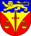
| Blazon : "Under a blue pewter shield head, inside a golden lion striding and looking ahead , in red a golden scales, split by a golden overturned point , inside a red overturned sword." | |
Culture and sights
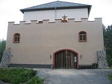
The old castle of Rotzenhahn from the second half of the 13th century is located in Rotenhain . The "castle" is a late medieval tower hill castle ( motte ), it probably served as a customs post on the old trade route. The area of the old castle is 240 square meters (16 × 15 m), the tower castle has a two-storey substructure with battlements and a single-storey superstructure. The Historica Rotenhain eV association has reconstructed the old castle. Over 6,000 working hours and half a million euros were invested in rebuilding and furnishing the castle in keeping with the style. Its foundation was found in 1997 during construction work in the Alte Burg district .
The parish church of St. Martin dates from 1220. The current nave was built in 1743. In 1939 the partially Romanesque tower was demolished and replaced by a new building. At the same time, the ship was extended to the west. The choir, which was probably still Gothic, was later demolished in order to expand the nave to the east. A wall mosaic made of over 50,000 individual stones is well worth seeing. The church has a bell from 1400 and one from 1458.
Economy and Infrastructure
traffic
- The federal highway 255 , which leads from Montabaur to Herborn , runs southwest of the municipality . The next motorway junction is Montabaur on the A3 Cologne - Frankfurt am Main .
- Rotenhain is located on the Oberwesterwaldbahn , on which the trains of the line RB 90 of the Hessische Landesbahn , Dreiländerbahn area according to the Rhineland-Palatinate cycle every hour from Limburg (Lahn) via Westerburg, Hachenburg, Altenkirchen, Au (Sieg), Betzdorf, Wissen (Sieg ) and Siegen to Kreuztal.
- At the Au (Sieg) train station there is a connection to the Rhein-Sieg-Express RSX which commutes as RE 9 from Aachen via Cologne, Troisdorf, Siegburg / Bonn and Betzdorf (Sieg) to Siegen, to the S 12 which runs from Düren via Cologne to Au as well as to the regional train in the direction of Siegen.
- At Limburg (Lahn) train station, there is a connection to the regional trains in the direction of Frankfurt, Wiesbaden, Koblenz, Gießen and Montabaur / Siershahn.
See also
literature
- Hellmuth Gensicke : Parish and court of Rotenhain. In: Nassau Annals . 79th Volume, 1968, pp. 241-262.
Web links
Individual evidence
- ↑ State Statistical Office of Rhineland-Palatinate - population status 2019, districts, communities, association communities ( help on this ).
- ↑ State Statistical Office Rhineland-Palatinate (ed.): Official directory of the municipalities and parts of the municipality. Status: January 2019 [ Version 2020 is available. ] . S. 82 (PDF; 3 MB).
- ↑ Official municipality directory 2006 ( Memento from December 22, 2017 in the Internet Archive ) (= State Statistical Office Rhineland-Palatinate [Hrsg.]: Statistical volumes . Volume 393 ). Bad Ems March 2006, p. 194 (PDF; 2.6 MB). Info: An up-to-date directory ( 2016 ) is available, but in the section "Territorial changes - Territorial administrative reform" it does not give any population figures.
- ^ The Regional Returning Officer Rhineland-Palatinate: Local elections 2019, city and municipal council elections
- ↑ a b Angela Baumeier: WZ locally in Rotenhain: A village for all generations. In: Westerwälder Zeitung. Mittelrhein-Verlag GmbH, Koblenz, November 29, 2018, accessed on July 12, 2020 .
- ^ The Regional Returning Officer Rhineland-Palatinate: direct elections 2019. see Westerburg, Verbandsgemeinde, 18th line of results. Retrieved July 12, 2020 .
- ^ Association Historica Rotenhain
- ↑ Westerwälder-Zeitung
- ↑ Representation of Rotenhain in the Wanderatlas Germany


