
List of districts and independent cities in Brandenburg
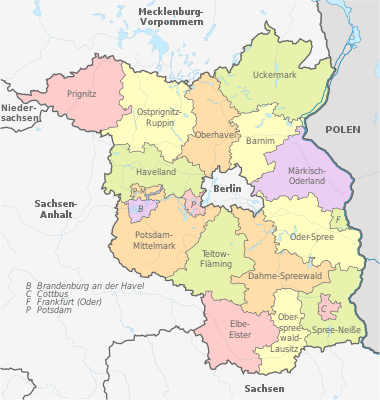
The state of Brandenburg is subdivided into a total of 14 districts and four independent cities . This list of the districts and independent cities in Brandenburg gives a general overview of these including their most important data. The current administrative structure of the country came about through the district reform of December 6, 1993 , in which the previous 38 districts and six independent cities were restructured. What was unique was that none of the new districts was named after its district town.
With an area of 29,654.36 square kilometers, the state of Brandenburg is the fifth largest state in the Federal Republic of Germany . In terms of population, it ranks tenth with 2,521,893 people. The average population density is 85 inhabitants per square kilometer, although this can vary greatly within the individual districts. The population density in the state capital Potsdam is 956 inhabitants per square kilometer, in the Barnim district 125 inhabitants per square kilometer and in the Prignitz district only 36 inhabitants per square kilometer. The most populous district is the district of Potsdam-Mittelmark with 216,566 inhabitants, the poorest in the district of Prignitz with 76,158 inhabitants. The largest independent city is the state capital Potsdam with 180,334 inhabitants. The largest district in terms of area is the Uckermark district , which is the sixth largest district in Germany at 3,076.93 square kilometers. The smallest district is the Oberspreewald-Lausitz district with an area of 1,223.08 square kilometers .
construction
The following list is structured as follows:
- District, independent city: Name of the district or the independent city: The official Lower Sorbian names that are sometimes used are put in italics in brackets. Cities not belonging to a district are indicated one line below.
- District town: Name of the district town: The cell is empty for urban districts.
- Coat of arms: the official coat of arms of the district or the independent city
- Motor vehicle: vehicle registration number of the respective regional authority
- Ew: Population of the respective regional authorities as of December 31, 2019
- Area: Area of the respective regional authorities in square kilometers (km²)
- Ew / km²: population density in inhabitants per square kilometer.
- Notes: further information regarding bordering federal states or neighboring states, special features and the like
- Image: a typical image from the region with which the respective regional authority is identified
Overview
| District, independent city |
County seat | coat of arms | map | Vehicle | Ew | Area (in km²) |
Ew / km² | Remarks | image |
|---|---|---|---|---|---|---|---|---|---|
| Barnim | Eberswalde |

|

|
BAR, BER, EW | 185.244 | 1,479.67 | 125 | borders on Berlin and Poland ; originated from the districts of Bernau , Eberswalde and parts of Bad Freienwalde |

|
|
Brandenburg an der Havel (independent city) |

|

|
BRB | 72.184 | 229.71 | 314 | Largest urban district in Brandenburg |

|
|
|
Cottbus (Chóśebuz) (independent city) |

|

|
CB | 99,678 | 165.15 | 604 |

|
||
|
Dahme-Spreewald (Damna-Błota) |
Luebben (Spreewald) |

|

|
LDS, KW, LC, LN | 170.791 | 2,274.48 | 75 | borders on Berlin ; largest natural lake in Brandenburg ( Schwielochsee ; 13.3 km²); originated from the districts of Königs Wusterhausen , Lübben and Luckau |

|
| Elbe Elster | Herzberg (Elster) |

|

|
EE, FI, LIB | 101,827 | 1,899.54 | 54 | highest point in Brandenburg ( Heidehöhe , 201.4 m); borders on Saxony and Saxony-Anhalt ; originated from the districts of Finsterwalde , Herzberg and parts of Bad Liebenwerda |

|
|
Frankfurt (Oder) (independent city) |
.png)
|

|
FF | 57,751 | 147.85 | 391 | smallest independent city in Brandenburg; borders on Poland |

|
|
| Havelland | Rathenow |

|

|
HVL, NAU, RN | 162.996 | 1,727.3 | 94 | borders on Berlin and Saxony-Anhalt ; originated from the districts of Nauen and Rathenow |

|
| Märkisch-Oderland | Seelow |

|

|
MOL, FRW, SEE, SRB | 195,751 | 2,158.67 | 91 | borders on Poland and Berlin ; originated from the districts of Seelow , Strausberg and parts of Bad Freienwalde |

|
| Oberhavel | Oranienburg |

|

|
OHV | 212.914 | 1,808.18 | 118 | borders on Berlin and Mecklenburg-Western Pomerania ; emerged from the Gransee and Oranienburg districts |

|
|
Oberspreewald-Lausitz (Górne Błota-Łužyca) |
Senftenberg |

|

|
OSL, CA, SFB | 109,371 | 1,223.08 | 89 | The smallest district in Brandenburg in terms of area; borders on Saxony ; largest artificial lake in Brandenburg ( Sedlitzer See ; 13.3 km²); originated from the districts of Calau , Senftenberg and parts of Bad Liebenwerda |

|
| Oder-Spree | Beeskow |

|

|
LOS, BSK, EH, FW | 178,803 | 2,256.78 | 79 | borders on Poland and Berlin ; emerged from the districts of Beeskow , Eisenhüttenstadt-Land and Fürstenwalde , as well as the independent city of Eisenhüttenstadt |

|
| Ostprignitz-Ruppin | Neuruppin |

|

|
OPR, KY, NP, WK | 98,861 | 2,526.55 | 39 | borders on Mecklenburg-Western Pomerania and Saxony-Anhalt ; emerged from the Neuruppin , Wittstock and parts of the Kyritz and Pritzwalk districts |

|
|
Potsdam (state capital) |

|

|
P | 180.334 | 188.61 | 956 | State capital; most populous city in Brandenburg; borders on Berlin |

|
|
| Potsdam-Mittelmark | Bad Belzig |

|

|
PM | 216,566 | 2,591.61 | 84 | most populous district of Brandenburg; District area divided by the city of Brandenburg an der Havel, borders Berlin and Saxony-Anhalt ; originated from the districts of Brandenburg , Belzig and Potsdam |

|
| Prignitz | Pearl Mountain |

|

|
PR | 76.158 | 2,138.61 | 36 | most populous district of Brandenburg; borders on Mecklenburg-Western Pomerania , Lower Saxony and Saxony-Anhalt ; emerged from the Perleberg district and parts of the Kyritz and Pritzwalk districts |

|
|
Spree-Neisse (Sprjewja-Nysa) |
Forst (Lausitz) |

|

|
SPN, FOR, GUB, SPB | 113,720 | 1,657.45 | 69 | borders on Poland and Saxony ; originated from the districts of Cottbus-Land , Forst , Guben and Spremberg |

|
| Teltow-Fläming | Luckenwalde |

|

|
TF | 169.997 | 2,104.19 | 81 | borders on Berlin and Saxony-Anhalt ; originated from the districts of Jüterbog , Luckenwalde and Zossen |

|
| Uckermark | Prenzlau |

|

|
UM, ANG, PZ, SDT, TP | 118,947 | 3,076.93 | 39 | the largest district in Brandenburg; borders on Poland and Mecklenburg-Western Pomerania ; originated from the districts of Angermünde , Prenzlau and Templin , as well as the independent city of Schwedt / Oder |

|
| Brandenburg | 2,521,893 | 29,654.36 | 85 | ||||||
See also
Individual evidence
- ↑ Official Journal for Brandenburg, Volume 19, Number 19 of May 14, 2008, pp. 1234–1236 (PDF; 1.1 MB)
- ↑ Population in the State of Brandenburg according to municipalities, offices and municipalities not subject to official registration on December 31, 2019 (XLSX file; 223 KB) (updated official population figures) ( help on this ).
- ↑ All politically independent municipalities with selected characteristics on September 30, 2016 (3rd quarter 2016) (accessed online on November 7, 2016)