
Heather height
| Heather height
Heideberg (Saxon side)
|
||
|---|---|---|
 The heath height seen from the north |
||
| height | 201.4 m above sea level NHN | |
| location | near Val Gardena and Strauch ; Brandenburg and Saxony ( Germany ) | |
| Mountains | Val Gardena mountains | |
| Coordinates | 51 ° 23 '6 " N , 13 ° 34' 30" E | |
|
||
| Type | glacial terminal moraine | |
| rock | Attachments of the Drenthe stage of the Saale icing | |
| Age of the rock | 210,000 to 165,000 years | |
| particularities | - highest elevation of the Val Gardena mountains and Brandenburg - Heidebergturm ( AT ) |
|

The Heidehöhe near Val Gardena , located on the Brandenburg side of the Heideberg , is 201.4 m above sea level. NHN the highest point in Brandenburg and lies on the border between this German state ( Elbe-Elster district ) and Saxony ( Meißen district ); the “highest mountain” in Brandenburg is called the Kutschenberg at 201 m . The Heidebergturm observation tower is on the Heidehöhe .
Geographical location
The Heidehöhe is located in the Val Gardena mountains about 2 km south of Val Gardena, 3 km west of Hirschfeld (both Brandenburg), 2 km north of Strauch (Saxony) and 3 km southeast of Merzdorf (Brandenburg).
North past the Heidehöhe, past Hirschfeld, Val Gardena and Merzdorf, the Pulsnitz flows in an east-west direction , to the west the Große Röder runs in a south-north direction and to the south in an east-west direction its tributary Elligastbach .
General


Height measurements in 2000 revealed that the Heidehöhe is the highest topographical elevation in Brandenburg. At this point in 2001 by the History Liebenwerda Working Group ( Kreismuseum Bad Liebenwerda ) a small granite monument erected to be read on: "HEATHER HEIGHT 201.4 m above sea level. NHN " .
In the immediate vicinity of this point, an artificially raised 5 m high hill with a trigonometric point can be seen, which is already on the Saxon side and reaches a height of 206.1 m. It served to create a trigonometric network of the Royal Saxon Triangulation , which was carried out from 1862 to 1890 on the territory of the Kingdom of Saxony and is considered the life's work of the Saxon professor Christian August Nagel . Some signs on site differentiate between the terms “Heidehöhe” (highest point in Brandenburg) and “Heideberg” (hill in Saxony).
Heideberg Tower

The densely wooded area of the Heidehöhe does not allow good views of the surrounding country. As early as 1853, a wooden tower was built by Bernhard von Rochow, the Strauch landowner. After it was destroyed by a storm in 1862, a massive tower was rebuilt. In 1945 it was finally destroyed. Later there was a wooden survey tower that was demolished around 1990.
In 2007, the municipal administration in Val Gardena decided to build a new observation tower. The 34 m high Heideberg tower was financed from municipal funds and should cost around 320,000 euros when construction began in April 2008. The planned completion date in September 2008 could not be met due to a construction stop imposed due to poor wood quality. It was not until almost a year later, on August 15, 2009, that the tower was inaugurated in the presence of the Val Gardena mayor Claus Vogt and the district administrator of the Elbe-Elster district, Klaus Richter . The tower is about 150 m east of the Heidehöhen summit and a few meters north of the border in the state of Brandenburg. Its construction is similar to the 28 m high Wehlaberg observation tower built in 2003 near Groß Wasserburg , but it is two floors higher. The roofed viewing platform, which is about 30 m high, can be reached via a total of 162 steps.
gallery
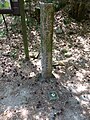
Stele and trigonometric point on the Heidehöhe in Brandenburg

historical triangulation stone station Strauch on the Heideberg in Saxony

Heideberg tower under construction (August 2008)


See also
literature
- Luise Grundmann, Dietrich Hanspach: The Schraden . In: Institut für Länderkunde Leipzig and the Saxon Academy of Sciences in Leipzig (ed.): A regional study in the area of Elsterwerda, Lauchhammer, Hirschfeld and Ortrand . Böhlau Verlag, Cologne / Weimar / Vienna 2005, ISBN 3-412-10900-2 .
- Dietrich Hanspach: On a summit hike on Saxony's border . In: Arbeitsgemeinschaft für Heimatkunde e. V. Bad Liebenwerda (Ed.): Local calendar for the old district of Bad Liebenwerda, the Mückenberger Ländchen, outskirts on Schraden and Uebigau-Falkenberg 1995 . Bad Liebenwerda 1995, p. 212-216 .
- Hartmut Adler: Where is Brandenburg's highest mountain? In: Arbeitsgemeinschaft für Heimatkunde e. V. Bad Liebenwerda (Ed.): Local calendar for the old district of Bad Liebenwerda, the Mückenberger Ländchen, outskirts on Schraden and Uebigau-Falkenberg 2002 . Bad Liebenwerda 2001, ISBN 3-932913-22-1 , p. 198-213 .
Individual evidence
- ↑ a b c Photo of the stele with inscription on the Heidehöhe .
- ↑ a b tower is still growing. In: Lausitzer Rundschau . July 11, 2008.
- ↑ Heidebergturm in the flyer "7 Towers in Schraden and the Dresdner Heidebogen" (PDF; 1.69 MB)
- ↑ Competition of the mountains in stations. ( Memento of the original from December 18, 2008 in the Internet Archive ) Info: The archive link was inserted automatically and has not yet been checked. Please check the original and archive link according to the instructions and then remove this notice. In: Lausitzer Rundschau. November 15, 2008.
- ↑ a b On Saturday the Heideberg Tower was inaugurated. In: Lausitzer Rundschau. dated August 17, 2009.
Web links
- Heideberg ( Heidehöhe ) , on amt-schradenland.de