Val Gardena (Brandenburg)
| coat of arms | Germany map | |
|---|---|---|

|
Coordinates: 51 ° 24 ' N , 13 ° 34' E |
|
| Basic data | ||
| State : | Brandenburg | |
| County : | Elbe Elster | |
| Office : | Schradenland | |
| Height : | 111 m above sea level NHN | |
| Area : | 22.14 km 2 | |
| Residents: | 1338 (Dec. 31, 2019) | |
| Population density : | 60 inhabitants per km 2 | |
| Postal code : | 04932 | |
| Area code : | 035343 | |
| License plate : | EE, FI, LIB | |
| Community key : | 12 0 62 196 | |
| Address of the municipal administration: |
Großenhainer Str. 25 04932 Val Gardena |
|
| Mayor : | Sebastian Rick ( CDU ) | |
| Location of the municipality of Val Gardena in the Elbe-Elster district | ||
Val Gardena is a municipality in the Elbe-Elster district in southern Brandenburg, about fifty kilometers north of the Saxon capital Dresden .
It is located in the south of the Schraden and is the administrative seat of the Schradenland office . In the southern municipal area on the border with Saxony is the Heidehöhe, the highest topographic point in the state of Brandenburg (201.4 m above sea level ).
geography
→ See also: Schraden (landscape)
Geographical location and natural space
Val Gardena is located in the Schraden, a lowland landscape at the confluence of the Black Elster and the Pulsnitz in the south-eastern part of the Elbe-Elster district in southern Brandenburg. The nearest city Elsterwerda is about 8 kilometers to the north, the Saxon state capital Dresden about 50 kilometers to the south.
The community is subdivided into the so-called upper village, which extends along the L 59, and the lower village, in the center of which there is a village green , which was once flowed through by a stream that was now piped. The north residential area also belongs to Val Gardena.
In the south of the municipality, on the border with Saxony, in the “Merzdorf-Hirschfelder Waldhöhen” nature reserve, the Heidehöhe is the highest topographic point in the state of Brandenburg (201.4 m above sea level ). The nature reserve "Untere Pulsnitzniederung" extends northwest of the Val Gardena locality.
climate
With its humid climate, Val Gardena lies in the cool, temperate climate zone , but a transition to the continental climate is noticeable. The nearest weather stations are to the north in Doberlug-Kirchhain , west of the town in Torgau and south in Oschatz and Dresden .
The month with the least rainfall is February, the wettest is July. The mean annual air temperature at the Doberlug-Kirchhain weather station about 30 kilometers to the north is 8.5 ° C. The annual fluctuation between the coldest month of January and the warmest month of July is 18.4 ° C.
|
Average monthly precipitation for Hirschfeld from 1951 to 1980
Source: Luise Grundmann, Dietrich Hanspach: Der Schraden , p. 14 ISBN 978-3-412-10900-4
|
|||||||||||||||||||||||||||||||||||||||||||||
history
Local history
Archaeological finds from the Bronze Age were made in the Val Gardena area in 1928 (two ribbon-shaped arm spirals, three bracelets and an arm cuff) and 1939 (bronze ax).
The place Val Gardena was first mentioned in documents around 1346. In an income directory from 1378 the place appears as "Graden", "Groden", 1495 also as Val Gardena. The place name derives from the Sorbian "grod", which means "fortified place" or "castle", "castle site". Val Gardena was owned by the Margraves of Meissn and belonged to the Hayn office . Around 1406 the size of the place was given as 37 hooves and 7 gardens. In 1547 there were 62 men living here, and Val Gardena owned 42 Hufen land. The people of Val Gardena owned rights to the former Schradenwald , for which interest had to be paid to the Elsterwerda rulership . The place was therefore the seat of a forester or head forester for centuries, and from 1708 there was also a gamekeeping department.
The town was badly damaged by fire in 1641 during the Thirty Years' War and in 1729.
As a result of the regulations of the Congress of Vienna in 1815, Val Gardena came from the Kingdom of Saxony to the administrative district of Merseburg in the Prussian province of Saxony . The place was incorporated into the newly created Liebenwerda district. At the former Prussian-Saxon border, which runs south of the village, boundary stones have been preserved up to the present day.
The beginning of industrialization in Germany in the 19th century was also evident in Val Gardena. In 1892 the clay pits "Agnes" and "Flora" were opened south of the municipality, in which 40 to 50 workers were employed and exploited the extensive clay deposits. A brick factory opened in 1887. A steam brick factory followed in 1905.
After the Second World War , the land reform in the GDR followed , and in 1960 the LPG “Free Land” was founded in Val Gardena , followed by the LPG “Glück auf” in 1968 and the LPG “Neues Land” from Plessa South in 1970 . In 1973, a mast runner production plant went into operation, a cooperation object of the agricultural production cooperatives from the Schraden communities of Val Gardena, Hirschfeld , Großthiemig and Merzdorf . In 1976 a drying plant followed, which in turn was a cooperation between a total of ten cooperatives in the Bad Liebenwerda district .
After the fall of the Wall , the largest biogas plant in Germany at that time went into operation in Val Gardena with an annual capacity of up to 110,000 tons of biomass and a designed production capacity of 3.65 million cubic meters of biogas .
Administrative affiliation
- until 1815 Liebenwerda ( Electorate of Saxony )
- 1816–1947 Liebenwerda district ( Province of Saxony , Prussia )
- 1947–1952 Liebenwerda district ( Saxony-Anhalt )
- 1952–1990 Bad Liebenwerda district ( Cottbus district )
- 1990–1993 Bad Liebenwerda district ( Brandenburg )
- from 1993 Elbe-Elster district (Brandenburg)
Population development
|
|
|
|
Territory of the respective year, number of inhabitants: as of December 31 (from 1991), from 2011 based on the 2011 census
politics
Community representation
The community council of Val Gardena consists of 10 community representatives and the honorary mayor. The local election on May 26, 2019 resulted in the following distribution of seats:
| Party / group of voters | Seats |
|---|---|
| CDU | 6th |
| Volunteer firefighter | 2 |
| Sports voters group | 1 |
| Individual applicant Claus Voigt | 1 |
mayor
- 1998–2019: Claus Voigt
- since 2019: Sebastian Rick (CDU)
Rick was elected unopposed in the mayoral election on May 26, 2019 with 84.3% of the valid votes for a five-year term.
coat of arms
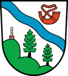
The Val Gardena coat of arms was approved on August 26, 2002.
Blazon : "In silver, a diagonal blue wavy bar, accompanied by a red hunting horn at the top and a green three-hill at the bottom, with a silver measuring stick with a red and silver divided base and two green fir trees with a black trunk."
Sights and culture
Buildings
In the list of architectural monuments in Val Gardena (Brandenburg) are the monuments of the place registered in the list of monuments of the state of Brandenburg.
On the village green of the so-called Unterdorf is the former school of Val Gardena, built from 1875 to 1876, which was replaced by a new school west of the Angers in the mid-1970s. A former blacksmith's shop can also be found here. The remains of a late Romanesque chapel are presumably hidden in the choir of the stone building of St. Martin's Church , which was built between 1552 and 1594 . In addition, there is a late Romanesque baptismal font, the central part of a late Gothic baptismal font and a triumphal cross from around 1400. The church was extensively renovated in 1978/79 and 2008/09. The colors yellow and white are the colors of the Baroque , from which most parts of the church come.
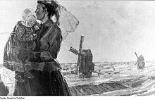
The former house built in 1906 and the studio of Schraden painter Professor Hans Nadler , father of the famous monument protector Hans Nadler , who died in Val Gardena in 1958, are located at Hans-Nadler-Straße 11 .
Other architectural monuments are "Schlegel's restaurant" with wine press (built in 1830), the building of the restaurant "Rautenstrauchs Erben" (built in 1796) and the building of the kindergarten built in 1962 in Grossenhainer Straße.
In the Upper Val Gardena there is a war memorial in the form of a stele, inaugurated in August 1891, in honor of the Val Gardena residents who died in the German War (1866) and the Franco-German War (1870/1871). After a restoration, the monument was re-inaugurated on September 9, 2006. A monument inaugurated on April 10, 2010 in the Gröden Cemetery honors 96 people from Val Gardena who fell in World War II.
Leisure and Tourism
Several cycle paths through the neighboring Schraden area connect Val Gardena with the Niederlausitzer Heidelandschaft nature park just a few kilometers to the north , the other Schraden communities, the sights of the lowlands and the surrounding area.
Some hiking trails and nature trails are marked in the Schraden Mountains. The approximately seven kilometer long “Heideberg circular route” provides information on eight boards about the respective locations and the special features of the landscape. The educational and adventure trail was set up in 2004. Along the Schachtweg, eleven large and fifteen small display boards provide information about the regional fauna and flora. In addition, a “path of the senses” was integrated into the nature trail, for which a forest path with different materials, e.g. B. sand, gravel, needle litter, pine cones was designed.
On the Eichberg in front of the Heidehöhe there is a ski slope, a ski lift and a ski hut for winter sports. The vantage point offers a distant view of the Schraden area and, in good weather conditions, to the Plessa power station and the disused F60 conveyor bridge , a project of the Fürst-Pückler-Land international building exhibition in Lichterfeld-Schacksdorf .
Another vantage point is located not far from the Eichberg on the Heidehöhe about two kilometers south of Val Gardena. Here is a 30 meter high observation tower, inaugurated on August 15, 2009, which also allows a distant view far into Saxony.
There are outdoor pools in the neighboring communities of Merzdorf and Großthiemig . A swimming pool can be found in Gröditz , Saxony, ten kilometers west of the municipality . In the spa town of Bad Liebenwerda , about twenty kilometers north-west of Val Gardena, there is the Fontana clinics and the "Lausitztherme Wonnemar", a health, recreation, wellness and tourism center.
In Elsterwerda there is a 30,000 square meter adventure miniature park and in Plessa with the adventure power plant a project of the international building exhibition Fürst-Pückler-Land as well as another interesting technical monument with the Elstermühle .
Museums
Val Gardena home parlor
Regular events
Werner Seelenbinder memorial run, open-air night every October, night football tournament, Christmas market, local children's festival
Economy and Infrastructure
In the east of the municipality is the approx. 30 hectare Val Gardena industrial park.
traffic
Val Gardena is on the L 59 national road between Gröditz and Ortrand . The nearest motorway junction is Ortrand on the A 13 Berlin – Dresden.
education
The “Waldhäuschen” day-care center is located on the outskirts of the village on Großenhainer Straße and is run by the municipality of Val Gardena. The facility has existed since 1961. In 1978 an annex was added to the building, and since May 2000 it has had its current name. The “Gröden Elementary School” is located in Gartenstraße.
There are secondary schools in Prösen, about eight kilometers to the north-west (Oberschule) and in the city of Elsterwerda (Oberschule, Gymnasium and other educational institutions).
Personalities
- Hans Nadler (1879–1958), Schraden painter , lived in Val Gardena
literature
- Sebastian Rick , Ernst Schmied, Berndt Engelmann, Rudi Apitz, Manja Engelmann: Festschrift for the 630th anniversary of the municipality of Val Gardena . Ed .: Municipality of Val Gardena. Self-published / printing house Starke & Sachse, Val Gardena 2008.
- Luise Grundmann, Dietrich Hanspach (author): The Schraden. A regional study in the Elsterwerda, Lauchhammer, Hirschfeld and Ortrand area . Ed .: Institute for Regional Geography Leipzig and the Saxon Academy of Sciences in Leipzig. Böhlau Verlag, Cologne / Weimar / Vienna 2005, ISBN 3-412-10900-2 .
- Sebastian Rick: "They plowed and they spread the seeds on the land" The collectivization of agriculture in Schradenland 1952-1960 . Val Gardena 2010.
Web links
- Office Schradenland
- Link catalog on the subject of Val Gardena at curlie.org (formerly DMOZ )
- Val Gardena in the RBB program Landschleicher on May 1st, 2005
Individual evidence
- ↑ Population in the State of Brandenburg according to municipalities, offices and municipalities not subject to official registration on December 31, 2019 (XLSX file; 223 KB) (updated official population figures) ( help on this ).
- ^ Service portal of the state administration Brandenburg. Val Gardena municipality
- ↑ Geoclimate 2.1
- ↑ Luise Grundmann, Dietrich Hanspach (author): Der Schraden. A regional study in the Elsterwerda, Lauchhammer, Hirschfeld and Ortrand area . Ed .: Institute for Regional Geography Leipzig and the Saxon Academy of Sciences in Leipzig. Böhlau Verlag, Cologne / Weimar / Vienna 2005, ISBN 3-412-10900-2 , p. 14 .
- ^ A b c Luise Grundmann, Dietrich Hanspach (author): Der Schraden. A regional study in the Elsterwerda, Lauchhammer, Hirschfeld and Ortrand area . Ed .: Institute for Regional Geography Leipzig and the Saxon Academy of Sciences in Leipzig. Böhlau Verlag, Cologne / Weimar / Vienna 2005, ISBN 3-412-10900-2 , p. 171-176 .
- ↑ a b c d Val Gardena on the homepage of the Schradenland office. Retrieved June 7, 2009 .
- ↑ Historical municipality register of the state of Brandenburg 1875 to 2005. Elbe-Elster district . Pp. 18-21
- ↑ Population in the state of Brandenburg from 1991 to 2015 according to independent cities, districts and municipalities , Table 7
- ^ Office for Statistics Berlin-Brandenburg (Ed.): Statistical report AI 7, A II 3, A III 3. Population development and population status in the state of Brandenburg (respective editions of the month of December)
- ^ Result of the local election on May 26, 2019
- ↑ Results of the municipal elections in 1998 (mayoral elections) for the Elbe-Elster district ( Memento of the original from April 21, 2018 in the Internet Archive ) Info: The archive link was inserted automatically and not yet checked. Please check the original and archive link according to the instructions and then remove this notice.
- ↑ Section 73 of the Brandenburg Local Election Act
- ^ Result of the mayoral election on May 26, 2019
- ↑ Coat of arms information on the service portal of the state administration of Brandenburg
- ^ Homepage of “Schlegel's Restaurant”. Retrieved June 7, 2009 .
- ^ The Val Gardena war memorial on the homepage of the Schradenland office. Retrieved June 8, 2009 .
- ↑ Online project Memorials to Fallen. Fallen Memorials online project, Lawrenceville, USA, accessed June 9, 2009 .
- ↑ New monument in Val Gardena. In: Lausitzer Rundschau . Regional section: Elsterwerda, April 9, 2010
- ↑ Late honor for 96 people from Val Gardena. In: Lausitzer Rundschau . Regional section: Finsterwalde, April 14, 2010.
- ↑ Internet presence of the Oberschule Prösen. Retrieved June 17, 2009 .


