
Spruce forest
| coat of arms | Germany map | |
|---|---|---|

|
Coordinates: 51 ° 42 ′ N , 13 ° 28 ′ E |
|
| Basic data | ||
| State : | Brandenburg | |
| County : | Elbe Elster | |
| Office : | Close | |
| Height : | 112 m above sea level NHN | |
| Area : | 31.76 km 2 | |
| Residents: | 614 (Dec. 31, 2019) | |
| Population density : | 19 inhabitants per km 2 | |
| Postal code : | 04936 | |
| Area code : | 035361 | |
| License plate : | EE, FI, LIB | |
| Community key : | 12 0 62 134 | |
| Community structure: | 3 districts | |
| Office administration address: | Herzberger Strasse 7 04936 Schlieben |
|
| Mayoress : | Peggy Bulst | |
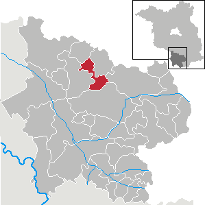
| Location of the municipality of Fichtwald in the Elbe-Elster district | ||
  |
||

The municipality of Fichtwald is located in the Elbe-Elster district in Brandenburg and belongs to the Schlieben office with its seat in the town of Schlieben .
geography
The community of Fichtwald is located in the eastern part of the spruce forest , a damp lowland area that is today characterized by meadows, pastures and arable land. The original moorland has been drained more and more since it was settled. The spruce forest is surrounded by six formerly independent villages, three of which became part of the municipality of Fichtwald. The other villages were Proßmarke, Wehrhain and Frankenhain . In the 19th century, peat was extracted from the spruce forest area. With the development of lignite in Lower Lusatia, peat lost its importance and agricultural use became more important again.
Community structure
Districts of the community are Hillmersdorf , Naundorf and Stechau .
history
Hillmersdorf, Naundorf and Stechau belonged to the Schweinitz district in the Prussian province of Saxony since 1816 and to the Herzberg district in the GDR district of Cottbus from 1952 . Since 1993 they have been in the Elbe-Elster district of Brandenburg.
The community of Fichtwald was created on December 31, 2001 from the voluntary amalgamation of the previously independent communities of Hillmersdorf, Naundorf and Stechau.
Population development
| year | Hillmersdorf | Naundorf | Stechau | year | Spruce forest | year | Spruce forest | ||
|---|---|---|---|---|---|---|---|---|---|
| 1875 | 300 | 370 | 300 | 2001 | 802 | 2015 | 673 | ||
| 1910 | 310 | 300 | 350 | 2005 | 735 | 2016 | 649 | ||
| 1939 | 293 | 231 | 342 | 2010 | 675 | 2017 | 625 | ||
| 1946 | 447 | 348 | 567 | 2011 | 660 | 2018 | 614 | ||
| 1950 | 445 | 332 | 556 | 2012 | 683 | 2019 | 614 | ||
| 1971 | 281 | 275 | 447 | 2013 | 685 | ||||
| 1990 | 219 | 243 | 421 | 2014 | 678 | ||||
| 1995 | 210 | 242 | 391 | ||||||
| 2000 | 206 | 240 | 358 |
Territory of the respective year, number of inhabitants: as of December 31, from 2011 based on the 2011 census
politics
Community representation
The community council of Fichtwald consists of eight community representatives and the honorary mayor. The local election on May 26, 2019 resulted in the following distribution of seats:
| Voter group | Seats |
|---|---|
| Citizens' Community Fichtwald | 5 |
| Free voter community Fichtwald | 2 |
| Individual applicant Maik Kuske | 1 |
mayor
- 2003–2014: Reinhard Schulze
- since 2014: Peggy Bulst (Bürgergemeinschaft Fichtwald)
Bulst was elected in the mayoral election on May 26, 2019 with 87.1% of the valid votes for a further five-year term.

Attractions
The list of monuments in Fichtwald includes the monuments entered in the list of monuments of the State of Brandenburg.
traffic
The federal road 87 , which connects Herzberg / Elster with Luckau , runs through the municipality . The district Hillmersdorf lies on the national road L 70 between Hohenbucko and Doberlug-Kirchhain .
Personalities
- Adam Heinrich Dresig (1701–1761), educator and classical philologist, born in Hillmersdorf
Web links
- Office close
- Link catalog on the topic of spruce forest at curlie.org (formerly DMOZ )
Individual evidence
- ↑ Population in the State of Brandenburg according to municipalities, offices and municipalities not subject to official registration on December 31, 2019 (XLSX file; 223 KB) (updated official population figures) ( help on this ).
- ^ Hans-Dieter Lehmann: The history of the Schliebener country . Book Chamber, Herzberg / Elster 2006
- ^ Service portal of the state administration Brandenburg. Fichtwald community
- ^ Formation of a new community in Fichtwald. Announcement of the Ministry of the Interior of October 9, 2001 Official Gazette for Brandenburg Common Ministerial Gazette for the State of Brandenburg, Volume 12, 2001, Number 44, Potsdam, October 30, 2001, p. 696 PDF
- ↑ Historical municipality register of the state of Brandenburg 1875 to 2005. Elbe-Elster district . Pp. 14-17
- ↑ Population in the state of Brandenburg from 1991 to 2015 according to independent cities, districts and municipalities , Table 7
- ^ Office for Statistics Berlin-Brandenburg (Ed.): Statistical report AI 7, A II 3, A III 3. Population development and population status in the state of Brandenburg (respective editions of the month of December)
- ^ Result of the local election on May 26, 2019
- ↑ Local elections October 26, 2003. Mayoral elections , p. 24
- ^ Result of the mayoral election on May 25, 2014
- ↑ Section 73 of the Brandenburg Local Election Act
- ^ Result of the mayoral election on May 26, 2019
Bad Liebenwerda | Crinitz | Doberlug-Kirchhain | Elsterwerda | Falkenberg / Elster | Spruce forest | Finsterwalde | Gorden-Staupitz | Val Gardena | Great | Heathland | Herzberg (Elster) | Hirschfeld | Hohenbucko | Hohenleipisch | Kremitzaue | Lebusa | Lichterfeld-Schacksdorf | Massen-Niederlausitz | Merzdorf | Mühlberg / Elbe | Plessa | Röderland | Rückersdorf | Sallgast | Schilda | Close | Schönborn | Schönewalde | Schraden | Sonnewalde | Trobitz | Uebigau-Wahrenbrück