
Röderland
| coat of arms | Germany map | |
|---|---|---|

|
Coordinates: 51 ° 26 ' N , 13 ° 28' E |
|
| Basic data | ||
| State : | Brandenburg | |
| County : | Elbe Elster | |
| Height : | 91 m above sea level NHN | |
| Area : | 46.2 km 2 | |
| Residents: | 3853 (Dec. 31, 2019) | |
| Population density : | 83 inhabitants per km 2 | |
| Postal code : | 04932 | |
| Primaries : | 03533, 035341 (OT Reichenhain) |
|
| License plate : | EE, FI, LIB | |
| Community key : | 12 0 62 410 | |
| LOCODE : | DE RZU | |
| Address of the municipal administration: |
Am Markt 1 04932 Röderland |
|
| Website : | ||
| Mayor : | Markus Terne | |
| Location of the municipality of Röderland in the Elbe-Elster district | ||
  |
||

Röderland is a municipality in the Elbe-Elster district in southern Brandenburg . It was created on October 26, 2003 from the voluntary amalgamation of the previously independent communities of Haida, Prösen, Reichenhain, Saathain, Stolzenhain and Wainsdorf of the Röderland office .
geography
location
Röderland lies on the rivers Schwarze Elster and Große Röder , the latter given its name to the unified municipality. In addition, the community territory is crossed by the Grödel-Elsterwerda raft canal , an artificially created canal for timber rafting between the Elbe and the Schwarzer Elster, which is a listed building .
climate
The area of the municipality of Röderland with its humid climate lies in the cool, temperate climate zone , but a transition to the continental climate is noticeable. The nearest weather stations are to the northeast in Doberlug-Kirchhain , west in Torgau and south in Oschatz and Dresden .
The month with the least precipitation is February, the wettest July. The mean annual air temperature at the Doberlug-Kirchhain weather station, located about 20 kilometers to the northeast, averaged 8.5 ° C between 1961 and 1990. The difference between the coldest month of January and the warmest month of July was 18.4 ° C.
Community structure
The community consists of the districts Haida , Prösen , Reichenhain , Saathain , Stolzenhain , Würdenhain and Wainsdorf . In addition comes abode Maiblumengehege .
The administrative seat of the municipality Röderland is in Prösen, the largest of the seven districts.
history
→ See also: History of the individual districts
Historically, the individual districts originally belonged to three different domains. While today's largest town, Prösen, like Saathain and Stolzenhain, was subject to the Saathain rulership , Reichenhain, Haida and Würdenhain belonged to the Würdenhain rulership , which was forcibly dissolved at the beginning of the 15th century and which became part of the Mühlberg rulership at that time . The Schradengemeinde Wainsdorf , on the other hand, belonged to the Frauenhain dominion in today's Saxony.


Saathain was first mentioned in a document in 1140 in a contract between Bishop Udo von Naumburg and Margrave Konrad von Meißen . The castle, originally called castrum Sathim , is one of the oldest known fortifications on the Black Elster. At the end of the Second World War, in April 1945 a deliberately set fire to the destruction of the castle, with numerous art treasures stored here and the old, extensive castle archive being lost.
Also in 1140 Prösen was first mentioned in a document. With the construction of the Elsterwerda-Grödel raft canal and the Elsterwerda – Dresden and Riesa – Elsterwerda railway lines , which emerged at the end of the 19th century, the place gained a certain economic importance and is now the largest part of the Local community.
In the smallest district of the municipality of Röderland, the Würdenhain , which was first mentioned in a document in 1346 , there was evidence of a fortified structure in the form of a castle or palace, as in Saathain, which was probably built in the first quarter of the 11th century. In 1370 the rule of Würdenhain was in the possession of the Roman-German Emperor Karl IV. The castle was destroyed in 1442 on the orders of the Saxon Elector Friedrich the Meek, as the vassal from Electoral Saxony had been guilty of breaching the peace and the territory was assigned to the neighboring rule Mühlberg. When the area came to the Bohemian nobleman Hinko Birke von der Duba through barter and purchase deals, the deed stated in the deed: "The Waell zcu Werdenhein should never be built on nor be built."
Haida , to the north, originally belonged to the Würdenhain rule . The place was first mentioned in 1349 as "Heyde" and was created in the formerly multi-armed river area of the Black Elster around a triangular village green that can still be seen today. In the middle of the 19th century the industrialization of the place began with the building permit for a brick kiln and the construction of the railway line Węgliniec – Falkenberg / Elster . Traditionally, gravel and sand extraction has been of great importance in the village alongside tree nurseries .
Reichenhain , mentioned in a document in 1335 as "Rychinheim" , originally belonged to the Würdenhain rulership like Haida. The first written mention of the neighboring Stolzenhain comes from the year 1406. Originally, the village belonged to the Saathain rule.
Wainsdorf , located on Schraden , was also mentioned in a document for the first time in 1406 . At that time the village was owned by the von Köckeritz lords , but it came to Otto von Pflug on Frauenhain as early as 1425 and later to the Zabeltitz rulership .
The current districts of the municipality of Röderland belonged to the district of Liebenwerda until 1952 , which existed from 1816 to 1952 in the Prussian province of Saxony , in the state of Saxony-Anhalt of the SBZ and in the GDR . The administrative reform of 1952 created the Bad Liebenwerda district in the Cottbus district , to which the municipalities belonged until 1993 (from 1990 in the state of Brandenburg). Since then they have belonged to the Elbe-Elster district .
Population development
|
|
|
|
Territory of the respective year, number of inhabitants: as of December 31, from 2011 based on the 2011 census
politics
Community representation
The community council of Röderland consists of 16 community representatives and the full-time mayor.
The local election on May 26, 2019 resulted in the following distribution of seats with a turnout of 52.5%:
| Party / group of voters | Seats |
|---|---|
| SPD | 3 |
| AfD | 2 |
| CDU | 2 |
| Free voting community Saathain | 2 |
| Haida voter community | 1 |
| The left | 1 |
| Independent voter community Stolzenhain | 1 |
| Reichenhain voter community | 1 |
| Independent voter association Wainsdorf | 1 |
| Voting community Würdenhain | 1 |
| Individual applicant Joachim Groß | 1 |
mayor
- 2003–2011: Heiderose Hubrig
- since 2011: Markus Terne
Terne was elected in the mayoral election on September 1, 2019 with 85.7% of the valid votes for a further term of eight years without a candidate.
coat of arms
The coat of arms of the municipality of Röderland was approved on December 2, 2003.
Blazon : "In red a silver-blue waved sloping bar, accompanied by four at the top by three golden lilies."
The coat of arms was designed by the heraldist Frank Diemar .
Attractions
→ See also: List of architectural monuments in Röderland and List of ground monuments in Röderland

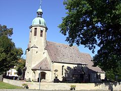
Reichenhain bell tower
Stolzenhain village church

War
memorial in Stolzenhain
St. Catherine Church in Würdenhain


Economy and Infrastructure
In the municipality there are mainly businesses in the service industry, handicrafts and agriculture. There are industrial parks in Prösen and Haida.
traffic
The federal highways B 101 between Bad Liebenwerda and Elsterwerda , B 169 between Elsterwerda and Riesa and the state road L 59 between Bad Liebenwerda and the Saxon state border run on the territory of the municipality of Röderland .
The stop Prösen-Ost (formerly Prösen-Wainsdorf ) is on the Berlin – Dresden railway line ( regional train line RB 31 Elsterwerda-Biehla - Dresden ). Prosen and Prösen-West on the Zeithain – Elsterwerda route are served by the regional train line RB 45 Elsterwerda - Chemnitz .
Personalities
Honorary citizen
- 2010, June 26: Helmut Walther (* 1920), Mayor of Reichenhain from 1961 to 1987
- 2015, July 26th: Heinz Drei 30 (* 1925), Mayor of Saathain from 1951 to 1990, received the "German Prize for Monument Protection" from the German National Committee for Monument Protection in 1991
Sons and daughters of the church
- Walther von Köckritz (? –1411), Bishop of Merseburg, born in Saathain
- Samuel August Wagner (1734–1788), doctor, born in Saathain
- Karl Benedikt Suttinger (1746–1830), educator, born in Saathain
- Johann Christian Jahn (1797–1846), educator, born in Stolzenhain
Personalities associated with Röderland
- Felix Hoffmann (1896–1968), local history researcher, lived in Haida
- Hans Wolfgang Bastian (1906–1942), pastor in Saathain
- Rudolf Matthies (1909–1996), local history researcher and teacher, lived in Haida
- Reinhard Höppner (1948–2014), politician (SPD), grew up in Prösen
- Ralf Minge (* 1960), national soccer player of the GDR, grew up in Prösen
Individual evidence
- ↑ Population in the State of Brandenburg according to municipalities, offices and municipalities not subject to official registration on December 31, 2019 (XLSX file; 223 KB) (updated official population figures) ( help on this ).
- ^ StBA: Changes in the municipalities in Germany, see 2003
- ↑ Geoclimate 2.1
- ^ Service portal of the state administration Brandenburg. Röderland municipality
- ↑ Luise Grundmann, Dietrich Hanspach (author): Der Schraden. A regional study in the Elsterwerda, Lauchhammer, Hirschfeld and Ortrand area . Ed .: Institute for Regional Geography Leipzig and the Saxon Academy of Sciences in Leipzig. Böhlau Verlag, Cologne, Weimar, Vienna 2005, ISBN 3-412-10900-2 , pp. 170/171 .
- ↑ Historical municipality register of the state of Brandenburg 1875 to 2005. Elbe-Elster district . Pp. 22-25
- ↑ Population in the state of Brandenburg from 1991 to 2015 according to independent cities, districts and municipalities , Table 7
- ^ Office for Statistics Berlin-Brandenburg (Ed.): Statistical report AI 7, A II 3, A III 3. Population development and population status in the state of Brandenburg (respective editions of the month of December)
- ^ Result of the local election on May 26, 2019
- ↑ Local elections October 26, 2003. Mayoral elections , p. 24
- ^ Result of the mayoral election on September 11, 2011
- ↑ Brandenburg Local Election Act, Section 74
- ^ Result of the mayoral election on September 1, 2019
- ↑ Coat of arms information on the service portal of the state administration of Brandenburg
- ↑ Helmut Walther is Reichenhain's first honorary citizen. In: Lausitzer Rundschau . Regional edition Elsterwerda, June 29, 2010 ( digitized version )
Web links
- Link catalog on Röderland at curlie.org (formerly DMOZ )
Bad Liebenwerda | Crinitz | Doberlug-Kirchhain | Elsterwerda | Falkenberg / Elster | Spruce forest | Finsterwalde | Gorden-Staupitz | Val Gardena | Great | Heathland | Herzberg (Elster) | Hirschfeld | Hohenbucko | Hohenleipisch | Kremitzaue | Lebusa | Lichterfeld-Schacksdorf | Massen-Niederlausitz | Merzdorf | Mühlberg / Elbe | Plessa | Röderland | Rückersdorf | Sallgast | Schilda | Close | Schönborn | Schönewalde | Schraden | Sonnewalde | Trobitz | Uebigau-Wahrenbrück