Wainsdorf
|
Wainsdorf
Röderland municipality
Coordinates: 51 ° 24 ′ 33 ″ N , 13 ° 30 ′ 14 ″ E
|
|
|---|---|
| Height : | 92.3 m above sea level NN |
| Area : | 4.39 km² |
| Incorporation : | October 26, 2003 |
| Postal code : | 04932 |
| Area code : | 03533 |
Wainsdorf is a district of the municipality of Röderland in the south-eastern part of Brandenburg in the Elbe-Elster district .
geography
In Wainsdorf the federal road 101 crosses with the country road 102 ( Riesa -Ortrand). The Berlin - Dresden railway line touches the town on the western edge of the town.
history
The first written mention of Wainsdorf comes from the year 1406 . This entry goes back to the record book of the Dobrilugk monastery and shows the community as the property of the Lords of Köckeritz. The place has the character of a typical street village and originally did not have any rights of use to the directly neighboring Schradenwald . Its place name goes back to the personal name Wagan (o) .
In 1425 Wainsdorf was sold to Otto von Pflug auf Frauenhain . Later, however, the place came under the rule of Zabeltitz . In the Hayner registry , Wahnsdorf was listed around 1800 with 15½ Hufen Land.
As a result of the Congress of Vienna in 1815 , the town was separated from Saxony and incorporated into the Kingdom of Prussia . In 1830 the first schoolhouse in Wainsdorf was built and in 1835 the village had 35 houses and 136 inhabitants.
A first sports field was laid out in 1933 in Pfeifholz near "Beyers Teich".
After the end of the Second World War and the later establishment of the German Democratic Republic , Wainsdorf belonged to the Cottbus district .
On December 10, 2000, the inauguration of the renovated community pond took place with a pond festival and on April 23, 2001 the foundation stone for a multi-purpose building at the Wainsdorf sports field was laid.
As a result of a municipal reform , Wainsdorf became a part of the municipality of Röderland on October 26, 2003.
Population development
| Population development of Wainsdorf from 1875 to 2002 | |||||||||||||
|---|---|---|---|---|---|---|---|---|---|---|---|---|---|
| year | Residents | year | Residents | year | Residents | year | Residents | year | Residents | ||||
| 1875 | 250 | 1946 | 621 | 1989 | 512 | 1995 | 470 | 2001 | 465 | ||||
| 1890 | 250 | 1950 | 587 | 1990 | 508 | 1996 | 460 | 2002 | 467 | ||||
| 1910 | 300 | 1964 | 549 | 1991 | 483 | 1997 | 458 | ||||||
| 1925 | 353 | 1971 | 550 | 1992 | 468 | 1998 | 470 | ||||||
| 1933 | 423 | 1981 | 525 | 1993 | 473 | 1999 | 475 | ||||||
| 1939 | 442 | 1985 | 521 | 1994 | 470 | 2000 | 472 | ||||||
Culture and sights
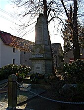
- War memorial
- The stele made of gray granite stone commemorates the fallen inhabitants of Wainsdorf during the two world wars.
- Saxon-Prussian boundary stones
- Along the former Saxon-Prussian border line that was created in 1815 as a result of the Congress of Vienna, boundary stones were set up between 1817 and 1818, which are now a listed building. According to an inventory from 1997 and 1998, 22 of the former 28 specimens that were in the Schraden area between Heinersdorf in the east and Wainsdorf in the west are still available. The stones in this area, which were once made of so-called Posta sandstone in the form of prisms or truncated pyramids, are numbered on two sides with the letters "KS" for the Kingdom of Saxony and "KP" for the Kingdom of Prussia .
Footnotes and individual references
- Size of the district area (status: 1995) from the collective of authors of the MUG Brandenburg eV: Heimatbuch Landkreis Elbe-Elster . Herzberg 1996, p. 119 .
- ↑ Luise Grundmann, Dietrich Hanspach (author): Der Schraden. A regional study in the Elsterwerda, Lauchhammer, Hirschfeld and Ortrand area . Ed .: Institute for Regional Geography Leipzig and the Saxon Academy of Sciences in Leipzig. Böhlau Verlag, Cologne, Weimar, Vienna 2005, ISBN 3-412-10900-2 , pp. 170/171 .
- ↑ Historical municipality directory 2005 for Brandenburg Online as a PDF file (accessed in March 2010)
- ↑ The Wainsdorfer war memorial in the online project war memorials (accessed in March 2010)


