
Kremitzaue
| coat of arms | Germany map | |
|---|---|---|

|
Coordinates: 51 ° 43 ' N , 13 ° 19' E |
|
| Basic data | ||
| State : | Brandenburg | |
| County : | Elbe Elster | |
| Office : | Close | |
| Height : | 85 m above sea level NHN | |
| Area : | 23.59 km 2 | |
| Residents: | 801 (Dec. 31, 2019) | |
| Population density : | 34 inhabitants per km 2 | |
| Postcodes : | 04916 (Polzen) , 04936 (Kolochau, Malitschkendorf) |
|
| Area code : | 035361 | |
| License plate : | EE, FI, LIB | |
| Community key : | 12 0 62 282 | |
| Community structure: | 3 districts | |
| Office administration address: | Herzberger Strasse 7 04936 Schlieben |
|
| Website : | ||
| Mayor : | Reinhard Claus | |
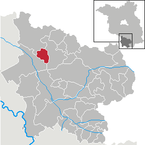
| Location of the municipality of Kremitzaue in the Elbe-Elster district | ||
  |
||

Kremitzaue is a municipality in the Elbe-Elster district in Brandenburg (Germany). It belongs to the office of Schlieben based in the city of Schlieben .
geography
In terms of landscape, the municipality forms the transition between the typical lowland of the Black Elster in the west and the glacial hilly landscape in the north and east of the northern Elbe-Elster district .
Community structure
Kremitzaue consists of the districts Kolochau , Malitschkendorf and Polzen.
history
In 1346 Kolochau was first mentioned in a document in the Meißner diocese registers .
Malitschkendorf can be found for the first time in 1290 in the Doberlug monastery record book . The name is a German-Slavic mixture. It goes back either to the personal name Malutschka or to the meaning of very small village .
Polzen was first mentioned around 1420 as "Bolczin".
Kolochau, Malitschkendorf and Polzen belonged to the Schweinitz district in the Prussian province of Saxony since 1816 and to the Herzberg district in the GDR district of Cottbus from 1952 . Since 1993 they have been in the Elbe-Elster district of Brandenburg.
The municipality of Kremitzaue emerged on December 31, 2001 from the voluntary amalgamation of the previously independent municipalities of Kolochau, Malitschkendorf and Polzen.
Population development
| year | Kolochau | Malitschkendorf | Polzen | year | Kremitzaue | year | Kremitzaue | ||
|---|---|---|---|---|---|---|---|---|---|
| 1875 | 480 | 260 | 320 | 2001 | 1 021 | 2015 | 809 | ||
| 1910 | 480 | 250 | 340 | 2005 | 989 | 2016 | 803 | ||
| 1939 | 501 | 237 | 378 | 2010 | 921 | 2017 | 788 | ||
| 1946 | 656 | 361 | 515 | 2011 | 876 | 2018 | 806 | ||
| 1950 | 654 | 319 | 496 | 2012 | 865 | 2019 | 801 | ||
| 1971 | 546 | 247 | 401 | 2013 | 830 | ||||
| 1990 | 480 | 215 | 329 | 2014 | 828 | ||||
| 1995 | 710 | 200 | 328 | ||||||
| 2000 | 466 | 212 | 340 |
Territory of the respective year, number of inhabitants: as of December 31, from 2011 based on the 2011 census
politics
Community representation
The municipal council of Kremitzaue consists of 10 municipal representatives and the honorary mayor. The local election on May 26, 2019 resulted in the following distribution of seats:
| Voter group | Seats |
|---|---|
| Kolochauer Independent Community of Voters | 5 |
| Polzen community of voters | 3 |
| Voter community Malitschkendorf | 2 |
mayor
- since 2003: Reinhard Claus (Kolochauer Independent Voting Association)
In the mayoral election on May 26, 2019, Claus was elected unopposed with 78.5% of the valid votes for a further term of five years.
Attractions
In the list of monuments in Kremitzaue are the monuments entered in the list of monuments of the state of Brandenburg.
traffic
Kremitzaue is on the federal highway 87 between Herzberg (Elster) and Schlieben .
The Kolochau stop was on the Falkenberg / Elster – Beeskow railway line , which was closed in 1995.
Sons and daughters of the church
- Carl August Gadegast (1791–1865), merino sheep breeder , born in Kolochau
- Friedrich Stoy (1887–1978), local researcher and teacher, born in Kolochau
Individual evidence
- ↑ Population in the State of Brandenburg according to municipalities, offices and municipalities not subject to official registration on December 31, 2019 (XLSX file; 223 KB) (updated official population figures) ( help on this ).
- ^ Service portal of the state administration Brandenburg. Kremitzaue community
- ↑ Märkische Oderzeitung / Frankfurter Stadtbote, August 1, 2006, p. 9
- ↑ StBA: Changes in the municipalities in Germany, see 2001
- ↑ Historical municipality register of the state of Brandenburg 1875 to 2005. Elbe-Elster district . Pp. 18-21
- ↑ Population in the state of Brandenburg from 1991 to 2015 according to independent cities, districts and municipalities , Table 7
- ^ Office for Statistics Berlin-Brandenburg (Ed.): Statistical report AI 7, A II 3, A III 3. Population development and population status in the state of Brandenburg (respective editions of the month of December)
- ^ Result of the local election on May 26, 2019
- ↑ Local elections October 26, 2003. Mayoral elections , p. 24
- ↑ Brandenburg Local Election Act, Section 73 (1)
- ^ Result of the mayoral election on May 26, 2019
Web links
- Office close
- Link catalog on the topic of Kremitzaue at curlie.org (formerly DMOZ )
Bad Liebenwerda | Crinitz | Doberlug-Kirchhain | Elsterwerda | Falkenberg / Elster | Spruce forest | Finsterwalde | Gorden-Staupitz | Val Gardena | Great | Heathland | Herzberg (Elster) | Hirschfeld | Hohenbucko | Hohenleipisch | Kremitzaue | Lebusa | Lichterfeld-Schacksdorf | Massen-Niederlausitz | Merzdorf | Mühlberg / Elbe | Plessa | Röderland | Rückersdorf | Sallgast | Schilda | Close | Schönborn | Schönewalde | Schraden | Sonnewalde | Trobitz | Uebigau-Wahrenbrück