
Schraden (municipality)
| coat of arms | Germany map | |
|---|---|---|

|
Coordinates: 51 ° 26 ' N , 13 ° 42' E |
|
| Basic data | ||
| State : | Brandenburg | |
| County : | Elbe Elster | |
| Office : | Plessa | |
| Height : | 92 m above sea level NHN | |
| Area : | 16.49 km 2 | |
| Residents: | 501 (Dec. 31, 2019) | |
| Population density : | 30 inhabitants per km 2 | |
| Postal code : | 04928 | |
| Area code : | 03574 | |
| License plate : | EE, FI, LIB | |
| Community key : | 12 0 62 464 | |
| Office administration address: | Steinweg 6 04928 Plessa |
|
| Website : | ||
| Mayor : | Olaf Redlich | |
| Location of the municipality of Schraden in the Elbe-Elster district | ||
  |
||

Schraden is a municipality in the Elbe-Elster district in Brandenburg and belongs to the Plessa office .
The place, located in the Schraden lowland landscape of the same name , was founded in 1929 from the former estate of Lindenau / Großkmehlen and parts of the Frauwalde, Großthiemig and Hirschfeld districts.
geography
The municipality of Schraden is located in the Schraden lowland of the same name in the east of the Elbe-Elster district. To the east of the municipality, Oberlausitz joins in the Oberspreewald-Lausitz district . The Schwarzen Elster flows through Schraden on the northern municipal boundary . The Pulsnitz flows through the lowland about two kilometers south of the municipality .
The Kaupen, Oberbuschhaus and Rothes Buschhaus residential areas belong to the Schraden community . Furthermore, the former Vorwerk Schradenau can be found in the northeast of the municipality , which is also shown as Lappige jacket on some topographic maps .
The districts of Frauwalde, Großthiemig, Hirschfeld, Plessa, Lauchhammer, Tettau and Lindenau join the municipal boundaries.

Vorwerk Schradenau (2017), also known as the Lappige Jacket .

history
Early history
The first traces of human settlement in the area of today's municipality of Schraden come from the Bronze Age , which were found in the district of Kaupen and in 1956 near the chief forestry officer Buschhaus. While it was grave finds in Kaupen, it was a bronze rag ax at the chief forester's office in Buschhaus .
Schradenvorwerke

The first works in the area of today's municipality Schraden were built at the end of the 17th century. The Oberbuschhaus Vorwerk belonged to the Elsterwerda estate . In 1727 it covered 76.36 hectares. The Vorwerk Rothes Buschhaus belonged to the Großkmehlen rule . In the middle of the 19th century, the Vorwerk Buschhaus also appeared on the maps. This also belonged to Großkmehlen. The Buschhaus later became the Huthaus and finally the Kaupen-Vorwerk .
It wasn't long before the two gentlemen got in each other's way during their activities in the Schraden, which led to legal battles. Such quarrels are documented as early as 1695 and 1707.
Another Vorwerk in the area of today's municipality was Schradenau , which was later referred to as Lappige jacket due to its poor condition and appears under this name in topographical maps.
Separations in the middle of the 19th century and the first settlement in Schraden
As a result of the regulation of the Schwarzen Elster in the middle of the 19th century, separations became necessary in Schraden , as the groundwater level in the lowland had fallen by about one meter as a result of extensive amelioration work and a total of 80,000 acres of swamp was made usable. The municipality of Val Gardena north of the Neue Pulsnitz received extensive areas in the Schradenwald as compensation. The Plessa-Süd settlement was to be built here later. As a result of the separations, the reissue dam was also extended beyond the Vorwerk of the same name, which belongs to the Krauschützer domain, to Tettau.

At the beginning of the 20th century, considerations arose to settle the lowlands of the largely uninhabited Schraden. Extensive lignite deposits had been discovered above all in the northeast of the lowland, which led to rapid industrialization in the region with the construction of lignite opencast mines, briquette factories and power plants, which, among other things, led to an enormous population increase due to the increasing demand for workers. In an article published in the local history supplement Die Schwarze Elster of the Liebenwerdaer Kreisblatt in 1913, the agricultural district council described this development in the Liebenwerda district and the likely consequences. It was feared that farmers living in the region, who had to sell their property to the ever-expanding lignite mines, might migrate due to a lack of income opportunities in agriculture. Some of them had already been offered land for resettlement in Falkenberg and Theisa , but Schraden was the only option for a larger agricultural settlement.
The First World War began a year later . For the time being, it brought an abrupt end to the region’s further growth.
Foundation of the place and recent past


The Reich Settlement Act , which came into force shortly after the First World War on August 11, 1919 , ensured that the earlier considerations were taken up again. In August 1924, extensive forest, arable and meadow areas were sold in the eastern Schradenniederung, which were to be used for settlement construction. The municipality of Schraden was established here from 1929. The place was from the former gutszugehörigen outworks Lindenau / Großkmehlen and from parts of the districts established Frauwalde, Großthiemig and Hirschfeld. The community bears the same name as the Schraden lowland landscape surrounding it . In order to avoid disputes about the name of the municipality, this name was preferred to one of the associated places.
In the Second World War , 42 residents of the community died as soldiers. The land reform began in the Bad Liebenwerda district in autumn 1945. In accordance with the Land Reform Ordinance (BRVO), private and state property over 100 hectares with all buildings, living and dead inventory and other agricultural property was expropriated and divided. By March 1, 1946, a total of 9580 hectares had been expropriated and distributed in the district.
The Princess of Lynar , owner of a large part of the land belonging to Schraden, also lost land as a result of the 100 hectare limit being exceeded. In the course of the land reform, district statistics published later on April 3, 1948, showed that 293 hectares of land were expropriated.
As early as 1878, a school and prayer house, the Luisenschule, was built in the east of the community. The church belonging to it was originally parish to Großkmehlen, but in 1978 it changed to the parish of Lindenau. From the former Luisenschule a polytechnic high school developed in the GDR . After the political change in the GDR, the school was closed. The building is now used as a village community center.
Administrative affiliation
Since its foundation in 1929, Schraden has belonged to the Liebenwerda district in the Prussian province of Saxony and in the state of Saxony-Anhalt of the SBZ and GDR . With the territorial reform carried out in the GDR in 1952, Schraden came to the newly founded Bad Liebenwerda district in the Cottbus district . Since some areas of the Bad Liebenwerda district were assigned to the Senftenberg district , Schraden became the easternmost municipality in the new district.
After the reunification , Schraden was initially in the Bad Liebenwerda district in Brandenburg, where the municipality joined the Plessa office in 1992 . After the district reform in Brandenburg on December 6, 1993 , the municipality of Schraden was assigned to the newly founded district of Elbe-Elster .
Population development
|
|
|
|
|
Territory of the respective year, number of inhabitants: as of December 31 (from 1991), from 2011 based on the 2011 census
politics
Community representation
The community council of Schraden consists of six community representatives and the honorary mayor. The local election on May 26, 2019 resulted in the following distribution of seats:
| Individual applicants | Seats |
|---|---|
| Annelies Schober | 1 |
| Doreen rod | 1 |
| Jens Wagner | 1 |
| Dirk Bielert | 1 |
| Klaus Tenner | 1 |
| Helga Degen | 1 |
Olaf Redlich ran as both a community representative and mayor. His share of the vote in the election for community council corresponded to two seats. Since he accepted the election as mayor, these two seats in the municipal council remain vacant according to § 60 (3) of the Brandenburg Local Election Act.
mayor
- 1998-2003: Frank Sims
- 2003-2008: Günter Pfeiffer
- 2008-2014: Frank Sims
- since 2014: Olaf Redlich
In the mayoral election on May 26, 2019, an unopposed candidate was elected with 90.5% of the valid votes for a further term of five years.
Sights and culture
→ See also: List of architectural monuments in Schraden (municipality)
The Schradener church with adjoining school was built in 1878. The owner of the Großkmehlener Rittergut Freiherr Karl Eduard Zachariae von Lingenthal had the building built to make it easier for the Schraden children to attend school and the adults to attend church services. In honor of his wife, the complex was named Luisenschule .
There is also a memorial in Schraden for the local residents who died in the First and Second World Wars . The monument made of field stones, which is dated between 1920 and 1926, is surrounded by a triangular decorative square and is on the list of monuments of the state of Brandenburg.

Luis School with Church (2017)

Village community center
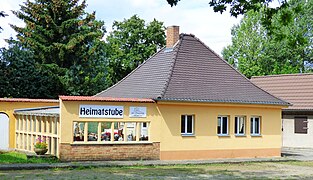
Home parlor
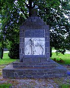
Fallen memorial


The local culture and sports center is located in the east of the community at the junction to Tettau. The complex, which is directly connected to the church with the former Luisenschule, includes, among other things, a local parlor, the village community center, an ice rink and a festival area. The Schraden day care center can also be found on the premises. Regular events in the village include the sports festival and the biker meeting.
Active clubs in the village are the village and sports club, the youth club, the senior and women's bowling group, the volunteer fire brigade, the Schraden citizens' initiative, the parish, the biker club Motorradfreunde Schraden - Tettau and the hunting cooperative Schraden.
Economy and Infrastructure
Schraden is traditionally characterized by agriculture. Some medium-sized businesses from agriculture, craft and service industries are located in the community.

traffic
The place is on the state road L 63 between the federal road 169 west of Lauchhammer and north of Frauwalde . In the Kaupen area, the L 631 road branches off in the direction of Plessa.
literature
- Luise Grundmann, Dietrich Hanspach (author): The Schraden. A regional study in the Elsterwerda, Lauchhammer, Hirschfeld and Ortrand area . Ed .: Institute for Regional Geography Leipzig and the Saxon Academy of Sciences in Leipzig. Böhlau Verlag, Cologne / Weimar / Vienna 2005, ISBN 3-412-10900-2 .
Footnotes and individual references
- ↑ Population in the State of Brandenburg according to municipalities, offices and municipalities not subject to official registration on December 31, 2019 (XLSX file; 223 KB) (updated official population figures) ( help on this ).
- ^ Service portal of the state administration Brandenburg. Schraden municipality
- ↑ a b c d e f Luise Grundmann, Dietrich Hanspach: Der Schraden. , P. 136
- ↑ a b c Luise Grundmann, Dietrich Hanspach: Der Schraden. , P. 120
- ↑ Luise Grundmann, Dietrich Hanspach: Der Schraden. , Pp. 1128/1129
- ↑ Luise Grundmann, Dietrich Hanspach: Der Schraden. , Pp. 174/175
- ↑ a b c d Luise Grundmann, Dietrich Hanspach: Der Schraden. , P. 132
- ↑ Willy Thiele: “You did not allow yourself to be discouraged!” In “The Black Elster - Our home in words and pictures” . No. 596 . Bad Liebenwerda 1985, p. 4 to 7 .
- ↑ a b Torsten Lehmann: The implementation of the land reform in the old district of Liebenwerda . In: Arbeitsgemeinschaft für Heimatkunde e. V. Bad Liebenwerda (Ed.): Local calendar for the old district of Bad Liebenwerda, the Mückenberger Ländchen, outskirts on Schraden and Uebigau-Falkenberg . Bad Liebenwerda 1997, p. 101 .
- ↑ Fritz Wilhelm: You fought for better Germany records about the anti-fascist resistance struggle in the Liebenwerda district . Ed .: District commission for research into the local history of the labor movement in the district leadership of the SED Bad Liebenwerda. S. 123 .
- ↑ a b c Frank Claus: "Schraden - that's where the mail goes" in Lausitzer Rundschau , July 25, 2017
- ↑ a b c Schraden parish website on the Plessa Office homepage, accessed on August 5, 2017
- ↑ Historical municipality register of the state of Brandenburg 1875 to 2005. Elbe-Elster district . Pp. 26-30
- ↑ Population in the state of Brandenburg from 1991 to 2015 according to independent cities, districts and municipalities , Table 7
- ^ Office for Statistics Berlin-Brandenburg (Ed.): Statistical report AI 7, A II 3, A III 3. Population development and population status in the state of Brandenburg (respective editions of the month of December)
- ^ Result of the local election on May 26, 2019
- ↑ Brandenburg Local Election Act, Section 60
- ↑ Results of the municipal elections in 1998 (mayoral elections) for the Elbe-Elster district ( Memento of the original from April 21, 2018 in the Internet Archive ) Info: The archive link was inserted automatically and not yet checked. Please check the original and archive link according to the instructions and then remove this notice.
- ↑ Local elections October 26, 2003. Mayoral elections , p. 24
- ↑ Local elections in the state of Brandenburg on September 28, 2008. Mayoral elections , p. 8
- ^ Result of the mayoral election on May 25, 2014
- ↑ Section 73 of the Brandenburg Local Election Act
- ^ Result of the mayoral election on May 26, 2019
- ↑ "Der Schraden Anno 1907" on the home page of the Hirschfeld home association, accessed on August 5, 2017
- ↑ Fallen Memorial Schraden in the online project Fallen Memorials , accessed on August 5, 2017
- ↑ Database of the Brandenburg State Office for the Preservation of Monuments and the State Archaeological Museum ( Memento of the original from December 9, 2017 in the Internet Archive ) Info: The archive link has been inserted automatically and has not yet been checked. Please check the original and archive link according to the instructions and then remove this notice. , accessed on August 6, 2017.
Web links
- Contribution to the RBB program Landschleicher on June 21, 2009
- Link catalog on the subject of Schraden at curlie.org (formerly DMOZ )
Bad Liebenwerda | Crinitz | Doberlug-Kirchhain | Elsterwerda | Falkenberg / Elster | Spruce forest | Finsterwalde | Gorden-Staupitz | Val Gardena | Great | Heathland | Herzberg (Elster) | Hirschfeld | Hohenbucko | Hohenleipisch | Kremitzaue | Lebusa | Lichterfeld-Schacksdorf | Massen-Niederlausitz | Merzdorf | Mühlberg / Elbe | Plessa | Röderland | Rückersdorf | Sallgast | Schilda | Close | Schönborn | Schönewalde | Schraden | Sonnewalde | Trobitz | Uebigau-Wahrenbrück