
Big Röder

The Große Röder is a left tributary of the Black Elster in Saxony and Brandenburg . Until the confluence with the Schwarzen Röder in Radeberg , it is also called the Weisse Röder .
course
The small river rises near the ramming Auer district Röder Brunn southwest of the high stone in Saxony in a resolution passed by wooden stakes source 326 meters off the highway A4 . It drains the western apron of the north- west Lusatian mountain and hill country . The total catchment area covers 934.5 square kilometers.
The Große Röder is dammed up in numerous ponds for keeping carp, at Röderbrunn in the Karauschen- or Karschtich (2.8 ha) and in the Rohr- or Rohrwiesenteich (2.1 ha), after 1.5 kilometers for bathing purposes in the Buschmühlenteich in Ohorn and on Bretniger Flur in the Brettmühlenteich. The Hauswald brook flows into the Große Röder near the former Bretniger brewery .
After it has crossed Großröhrsdorf , it flows between Wallroda and Radeberg through the Hüttertal , shortly afterwards it takes in the water of the Schwarzen Röder in Radeberg an der Mittelmühle and runs through the Gelbkehain , the Leithen , the Lotzdorfer and the Liegauer Rödertal. It forms the Seifersdorfer Tal between the Liegau-Augustusbad and Hermsdorf exit . The Kleine Röder , which rises near Lichtenberg, joins between Ottendorf-Okrilla and Medingen . In Radeburg it is dammed into a dam that is bounded by the dam on the A 13 motorway to the Radeburg reservoir . The Große Röder flows through the southwestern outflow of the reservoir to Rödern , Kalkreuth , Großenhain and Gröditz . After 105 kilometers it flows into the Black Elster west of Elsterwerda (Brandenburg) between Saathain and Würdenhain . Another branch of the estuary, also called Kleine Röder , flows shortly afterwards into the Black Elster near Zobersdorf .
The Röderradroute cycle path follows the course of the Großer Röder .
Surname
The river name is probably derived from the Middle Low German rét , which means Ried in High German - creek overgrown with reeds. The name has been changed many times, in 1790 Fahrrad-Fluss or Die Fahrrad for short , which could indicate the origin of Rad ... (similar to the supposed origins of the names of the towns of Radeberg and Radeburg on the river).
photos
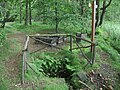
Röderquelle

Headwaters in Röderbrunn (spring in the forest at the top right of the picture; then the Röder flows through two small lakes near the A4 motorway: Karschtich on the right and Rohrteich on the left)

Hüttertal near Radeberg

Confluence of the Great and Black Röder

In the Seifersdorfer valley

Grundmühle in Liegau-Augustusbad

at the Zabeltitz baroque garden

Muzzle into the Black Elster


,_Germany,_Saxony.png)


literature
- Hydrological manual. (PDF; 115 kB) Part 2 - Area Codes. Free State of Saxony - State Office for Environment and Geology, p. 9 , accessed on December 25, 2017 .
- Dietrich Hanspach, Haik Thomas Porada: Grossenhainer care. A regional study of the area around Großenhain and Radeburg . Ed .: Institute for Regional Geography Leipzig and the Saxon Academy of Sciences in Leipzig. Böhlau Verlag, Cologne / Weimar / Vienna 2008, ISBN 978-3-412-09706-6 , p. 301-311 .
- Dresdner Heide, Pillnitz, Radeberger Land (= values of our homeland . Volume 27). 1st edition. Akademie Verlag, Berlin 1976, p. 41.
Individual evidence
- ↑ Hydrological Handbook. (PDF; 637 kB) Part 3 - Main aquatic values. Free State of Saxony - State Office for Environment and Geology, p. 49 , accessed on December 25, 2017 .
- ↑ a b Great Röder. In: Lausitzer Bergland around Pulsnitz and Bischofswerda (= values of our homeland . Volume 40). 1st edition. Akademie Verlag, Berlin 1983, pp. 97f.
- ^ Letters on the Radeberger Bad , Dresden, printed by Carl Christian Meinhold, 1790 online resource
Web links
- Current water levels and flow rates in the catchment area of the Black Elster in Saxony (Saxon State Ministry for Environment and Agriculture)